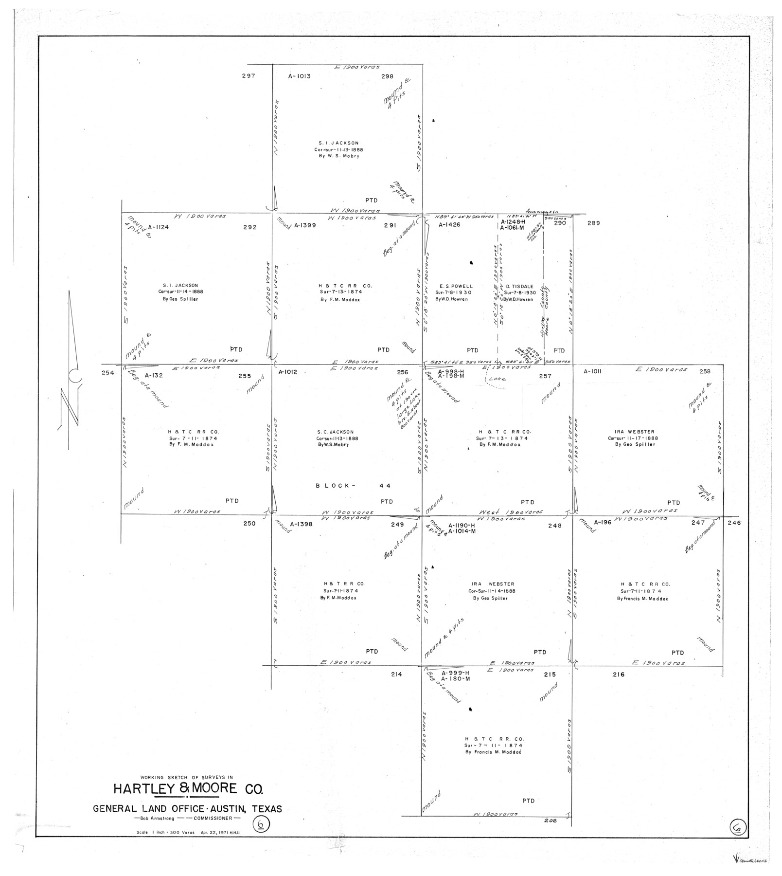
Hartley County Working Sketch 6
-
Map/Doc
66056
-
Collection
General Map Collection
-
Object Dates
4/22/1971 (Creation Date)
-
People and Organizations
Herbert H. Ulbricht (Draftsman)
-
Counties
Hartley Moore
-
Subjects
Surveying Working Sketch
-
Height x Width
37.0 x 37.0 inches
94.0 x 94.0 cm
-
Scale
1" = 300 varas
Part of: General Map Collection

Zavala County Rolled Sketch 14

Print $20.00
- Digital $50.00
Zavala County Rolled Sketch 14
1887
Size 28.1 x 40.8 inches
Map/Doc 10175
McLennan County Sketch File 15

Print $4.00
- Digital $50.00
McLennan County Sketch File 15
1872
Size 8.2 x 11.3 inches
Map/Doc 31274
Montague County Working Sketch 39

Print $20.00
- Digital $50.00
Montague County Working Sketch 39
1994
Size 34.4 x 45.0 inches
Map/Doc 71105
Gulf Intracoastal Waterway - Aransas Bay to Corpus Christi Bay, Modified Route of Main Channel Location of Spoil Disposal Areas

Print $20.00
- Digital $50.00
Gulf Intracoastal Waterway - Aransas Bay to Corpus Christi Bay, Modified Route of Main Channel Location of Spoil Disposal Areas
1961
Size 31.4 x 42.1 inches
Map/Doc 61829
Flight Mission No. DCL-7C, Frame 51, Kenedy County

Print $20.00
- Digital $50.00
Flight Mission No. DCL-7C, Frame 51, Kenedy County
1943
Size 16.6 x 16.4 inches
Map/Doc 86039
Erath County Rolled Sketch 1

Print $40.00
- Digital $50.00
Erath County Rolled Sketch 1
1962
Size 37.6 x 69.0 inches
Map/Doc 8882
Township No. 5 South, Range No. 14 West, Indian Meridian, Oklahoma

Print $4.00
- Digital $50.00
Township No. 5 South, Range No. 14 West, Indian Meridian, Oklahoma
1928
Size 18.0 x 22.6 inches
Map/Doc 75141
Garza County Sketch File J

Print $20.00
- Digital $50.00
Garza County Sketch File J
1911
Size 26.5 x 7.5 inches
Map/Doc 11555
Maps & Lists Showing Prison Lands (Oil & Gas) Leased as of June 1955

Digital $50.00
Maps & Lists Showing Prison Lands (Oil & Gas) Leased as of June 1955
1934
Size 19.1 x 38.7 inches
Map/Doc 62878
Chambers County Sketch File 44

Print $36.00
- Digital $50.00
Chambers County Sketch File 44
Size 13.9 x 8.7 inches
Map/Doc 17735
Crockett County Rolled Sketch 58

Print $20.00
- Digital $50.00
Crockett County Rolled Sketch 58
Size 19.0 x 32.8 inches
Map/Doc 5600
You may also like
Van Zandt County Sketch File 42

Print $4.00
- Digital $50.00
Van Zandt County Sketch File 42
1874
Size 10.0 x 8.1 inches
Map/Doc 39495
Stephens County Sketch File 17

Print $6.00
- Digital $50.00
Stephens County Sketch File 17
1912
Size 11.2 x 8.7 inches
Map/Doc 37074
Live Oak County Sketch File 1

Print $4.00
- Digital $50.00
Live Oak County Sketch File 1
1856
Size 11.5 x 7.8 inches
Map/Doc 30251
Briscoe County Sketch File G

Print $40.00
- Digital $50.00
Briscoe County Sketch File G
1918
Size 17.7 x 22.4 inches
Map/Doc 11004
Morris County Rolled Sketch 2A

Print $20.00
- Digital $50.00
Morris County Rolled Sketch 2A
Size 24.4 x 19.4 inches
Map/Doc 10245
Blanco County Working Sketch 7

Print $20.00
- Digital $50.00
Blanco County Working Sketch 7
1924
Size 12.9 x 12.1 inches
Map/Doc 67367
Ownership Map NW 1/4 Lubbock County

Print $20.00
- Digital $50.00
Ownership Map NW 1/4 Lubbock County
1926
Size 32.5 x 39.6 inches
Map/Doc 89698
Eastland County Working Sketch 38

Print $20.00
- Digital $50.00
Eastland County Working Sketch 38
1969
Size 28.9 x 28.6 inches
Map/Doc 68819
Cooke County Sketch File 28

Print $4.00
- Digital $50.00
Cooke County Sketch File 28
1872
Size 12.8 x 8.5 inches
Map/Doc 19281
Edwards County Working Sketch 46

Print $20.00
- Digital $50.00
Edwards County Working Sketch 46
1950
Size 39.8 x 37.4 inches
Map/Doc 68922
Freestone County Boundary File 1

Print $6.00
- Digital $50.00
Freestone County Boundary File 1
Size 14.2 x 8.8 inches
Map/Doc 53585
Dominguez Empresario Colony. February 6, 1829

Print $20.00
Dominguez Empresario Colony. February 6, 1829
2020
Size 17.2 x 21.7 inches
Map/Doc 95992