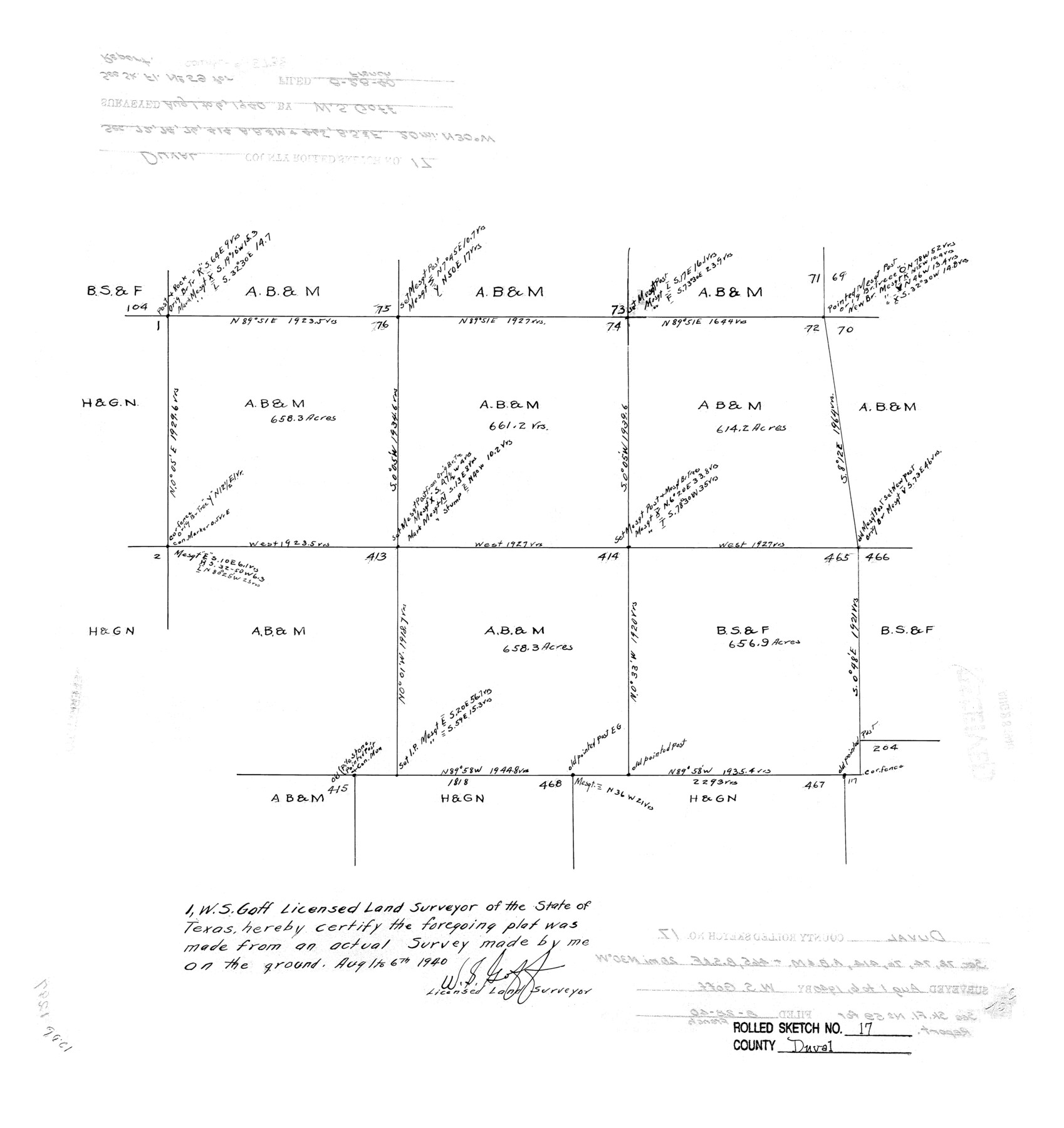
Duval County Rolled Sketch 17
[Sketch of A. B. & M. sections 72, 74, 76, and 414 and B. S. & F. section 465]
-
Map/Doc
5738
-
Collection
General Map Collection
-
Object Dates
1940/8/6 (Creation Date)
1940/8/28 (File Date)
-
People and Organizations
W.S. Goff (Surveyor/Engineer)
-
Counties
Duval
-
Subjects
Surveying Rolled Sketch
-
Height x Width
18.9 x 17.9 inches
48.0 x 45.5 cm
-
Comments
See Duval County Sketch File 59 (21425) for report.
Related maps
Duval County Sketch File 59

Print $6.00
- Digital $50.00
Duval County Sketch File 59
1940
Size 14.4 x 9.0 inches
Map/Doc 21425
Part of: General Map Collection
Randall County Rolled Sketch 8

Print $20.00
- Digital $50.00
Randall County Rolled Sketch 8
1975
Size 33.7 x 43.7 inches
Map/Doc 10620
Presidio County Rolled Sketch 126

Print $20.00
- Digital $50.00
Presidio County Rolled Sketch 126
1986
Size 27.8 x 39.4 inches
Map/Doc 7397
Foard County Rolled Sketch 13

Print $20.00
- Digital $50.00
Foard County Rolled Sketch 13
1958
Size 25.2 x 31.4 inches
Map/Doc 5887
Montague County Working Sketch 40

Print $20.00
- Digital $50.00
Montague County Working Sketch 40
1995
Size 20.6 x 17.5 inches
Map/Doc 71106
Flight Mission No. DAG-18K, Frame 181, Matagorda County

Print $20.00
- Digital $50.00
Flight Mission No. DAG-18K, Frame 181, Matagorda County
1952
Size 15.9 x 15.9 inches
Map/Doc 86373
Flight Mission No. BRE-2P, Frame 80, Nueces County

Print $20.00
- Digital $50.00
Flight Mission No. BRE-2P, Frame 80, Nueces County
1956
Size 18.4 x 22.5 inches
Map/Doc 86775
Right-of-Way Map Seawall Extension Galveston Island

Print $40.00
- Digital $50.00
Right-of-Way Map Seawall Extension Galveston Island
1958
Size 16.4 x 62.8 inches
Map/Doc 73617
Map of the Survey of the Parallel 36 1/2 Degrees North Latitude, Commencing at the 100th and Running to the 103rd Degree of Longitude West of Greenwich

Print $40.00
- Digital $50.00
Map of the Survey of the Parallel 36 1/2 Degrees North Latitude, Commencing at the 100th and Running to the 103rd Degree of Longitude West of Greenwich
1862
Size 87.1 x 11.1 inches
Map/Doc 3084
Terrell County Working Sketch 60

Print $40.00
- Digital $50.00
Terrell County Working Sketch 60
1962
Size 20.2 x 67.0 inches
Map/Doc 69581
Roberts County Rolled Sketch 3

Print $40.00
- Digital $50.00
Roberts County Rolled Sketch 3
Size 38.4 x 50.0 inches
Map/Doc 8358
Wichita County Working Sketch 9

Print $20.00
- Digital $50.00
Wichita County Working Sketch 9
1920
Size 23.7 x 17.6 inches
Map/Doc 72518
Jasper County Working Sketch 24
Print $40.00
- Digital $50.00
Jasper County Working Sketch 24
1948
Size 44.2 x 54.9 inches
Map/Doc 69651
You may also like
Hamilton County Rolled Sketch 3

Print $20.00
- Digital $50.00
Hamilton County Rolled Sketch 3
1919
Size 20.6 x 26.2 inches
Map/Doc 6070
Texas Panhandle East Boundary Line

Print $20.00
- Digital $50.00
Texas Panhandle East Boundary Line
Size 37.5 x 8.7 inches
Map/Doc 65381
Map of the City of Galveston, Texas

Print $40.00
- Digital $50.00
Map of the City of Galveston, Texas
1883
Size 37.2 x 66.3 inches
Map/Doc 96981
![93119, [Capitol Lands], Twichell Survey Records](https://historictexasmaps.com/wmedia_w700/maps/93119-1.tif.jpg)
Flight Mission No. DQO-1K, Frame 150, Galveston County

Print $20.00
- Digital $50.00
Flight Mission No. DQO-1K, Frame 150, Galveston County
1952
Size 19.1 x 22.6 inches
Map/Doc 85003
Chart of the West Indies and Spanish Dominions in North America

Print $20.00
- Digital $50.00
Chart of the West Indies and Spanish Dominions in North America
1803
Size 25.3 x 38.4 inches
Map/Doc 97136
Louisiana and Texas Intracoastal Waterway, Section 7, Galveston Bay to Brazos River and Section 8, Brazos River to Matagorda Bay

Print $20.00
- Digital $50.00
Louisiana and Texas Intracoastal Waterway, Section 7, Galveston Bay to Brazos River and Section 8, Brazos River to Matagorda Bay
1929
Size 30.8 x 43.0 inches
Map/Doc 61841
Galveston County Sketch File 63

Print $52.00
- Digital $50.00
Galveston County Sketch File 63
Size 11.3 x 8.9 inches
Map/Doc 23681
Colorado County Sketch File 8

Print $4.00
- Digital $50.00
Colorado County Sketch File 8
1861
Size 12.4 x 8.5 inches
Map/Doc 18927
Angelina County Working Sketch 22a

Print $20.00
- Digital $50.00
Angelina County Working Sketch 22a
1953
Size 22.3 x 20.1 inches
Map/Doc 67103
Lampasas County Rolled Sketch 3

Print $20.00
- Digital $50.00
Lampasas County Rolled Sketch 3
Size 43.8 x 33.9 inches
Map/Doc 9554
Willacy County Rolled Sketch 2

Print $40.00
- Digital $50.00
Willacy County Rolled Sketch 2
1921
Size 30.7 x 62.9 inches
Map/Doc 10145