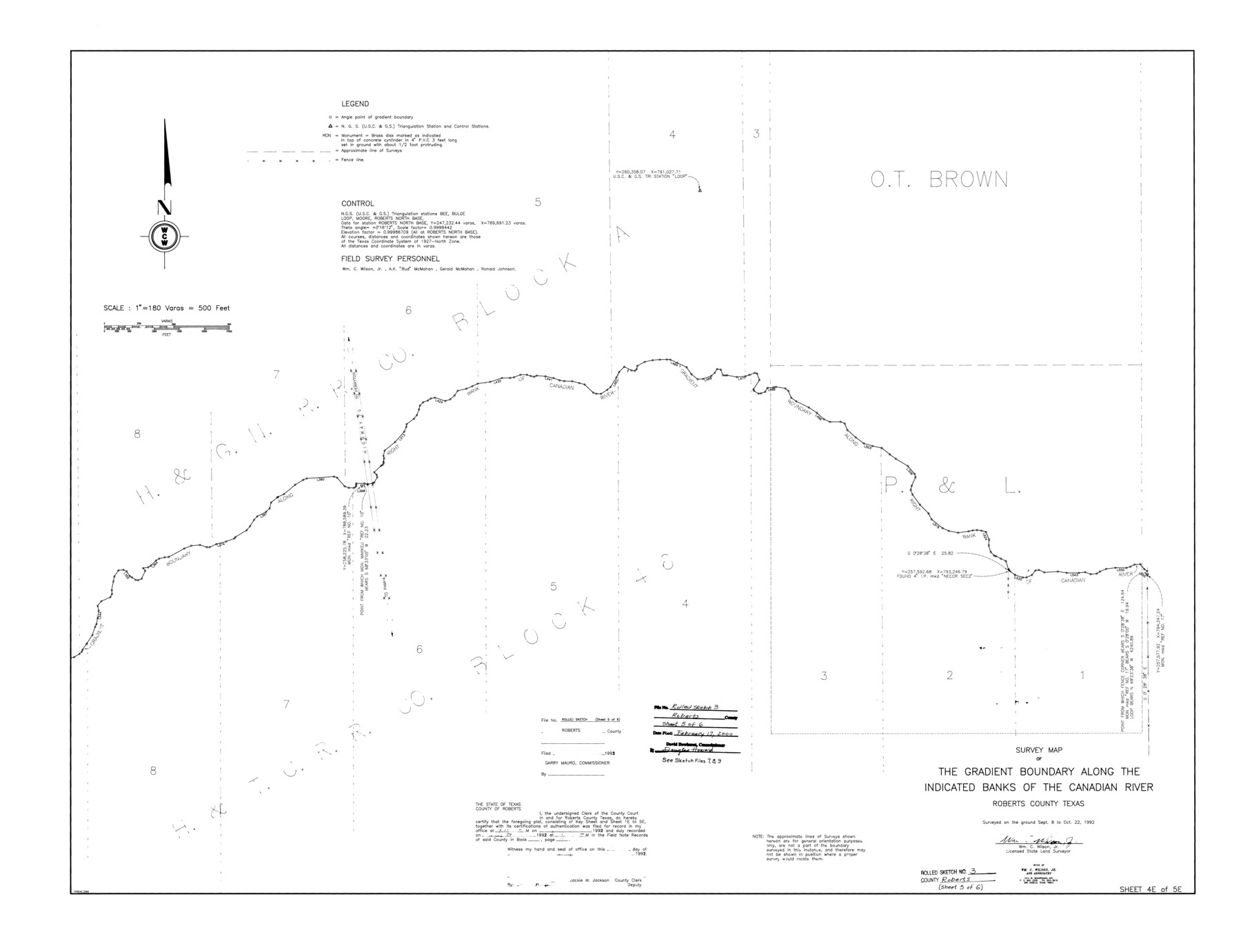
Roberts County Rolled Sketch 3
Survey map of the gradient boundary along the indicated banks of the Canadian River, Roberts County, Texas
-
Map/Doc
8358
-
Collection
General Map Collection
-
Object Dates
1992/10/22 (Survey Date)
2000/2/17 (File Date)
-
People and Organizations
Wm. C. Wilson, Jr. (Surveyor/Engineer)
-
Counties
Roberts
-
Subjects
Surveying Rolled Sketch
-
Height x Width
38.4 x 50.0 inches
97.5 x 127.0 cm
-
Medium
mylar, print
-
Scale
1" = 180 varas
-
Comments
One of six sheets. For all sheets see Roberts County Rolled Sketch 3 (8354-8359). Also see Roberts County Sketch File 7 (35316), Roberts County Sketch File 8 (35324), and Roberts County Sketch File 9 (35327) for field notes.
Related maps
Roberts County Sketch File 7

Print $16.00
- Digital $50.00
Roberts County Sketch File 7
1992
Size 14.3 x 8.8 inches
Map/Doc 35316
Roberts County Sketch File 8

Print $6.00
- Digital $50.00
Roberts County Sketch File 8
1992
Size 14.3 x 8.8 inches
Map/Doc 35324
Roberts County Sketch File 9

Print $26.00
- Digital $50.00
Roberts County Sketch File 9
1992
Size 14.3 x 9.0 inches
Map/Doc 35327
Roberts County Rolled Sketch 3

Print $40.00
- Digital $50.00
Roberts County Rolled Sketch 3
Size 38.0 x 49.7 inches
Map/Doc 8354
Roberts County Rolled Sketch 3

Print $40.00
- Digital $50.00
Roberts County Rolled Sketch 3
Size 38.0 x 49.7 inches
Map/Doc 8355
Roberts County Rolled Sketch 3

Print $40.00
- Digital $50.00
Roberts County Rolled Sketch 3
Size 38.0 x 49.7 inches
Map/Doc 8356
Roberts County Rolled Sketch 3

Print $40.00
- Digital $50.00
Roberts County Rolled Sketch 3
Size 38.0 x 49.7 inches
Map/Doc 8357
Roberts County Rolled Sketch 3

Print $40.00
- Digital $50.00
Roberts County Rolled Sketch 3
Size 37.7 x 48.9 inches
Map/Doc 8359
Part of: General Map Collection
La Salle County Rolled Sketch 24

Print $20.00
- Digital $50.00
La Salle County Rolled Sketch 24
1955
Size 36.7 x 39.4 inches
Map/Doc 10655
Leon County Rolled Sketch 28

Print $20.00
- Digital $50.00
Leon County Rolled Sketch 28
1993
Size 35.8 x 46.6 inches
Map/Doc 9438
Flight Mission No. DCL-7C, Frame 39, Kenedy County

Print $20.00
- Digital $50.00
Flight Mission No. DCL-7C, Frame 39, Kenedy County
1943
Size 15.3 x 15.3 inches
Map/Doc 86027
Terry County Boundary File 2a

Print $32.00
- Digital $50.00
Terry County Boundary File 2a
Size 11.6 x 8.9 inches
Map/Doc 59209
Leon County Rolled Sketch 10

Print $20.00
- Digital $50.00
Leon County Rolled Sketch 10
1962
Size 30.9 x 37.2 inches
Map/Doc 6598
Flight Mission No. DCL-7C, Frame 69, Kenedy County

Print $20.00
- Digital $50.00
Flight Mission No. DCL-7C, Frame 69, Kenedy County
1943
Size 15.4 x 15.2 inches
Map/Doc 86055
A2 - Part of the Boundary between the United States and Texas from Sabine River Northward to the 36th mile mound

Print $20.00
- Digital $50.00
A2 - Part of the Boundary between the United States and Texas from Sabine River Northward to the 36th mile mound
Size 28.5 x 22.0 inches
Map/Doc 94003
Map of Lake Travis with detailed maps of Lakeway, Briarcliff, Lago Vista, Highland Lake Estates

Map of Lake Travis with detailed maps of Lakeway, Briarcliff, Lago Vista, Highland Lake Estates
Size 23.0 x 35.3 inches
Map/Doc 94374
Map of Port Bolivar

Print $20.00
- Digital $50.00
Map of Port Bolivar
1893
Size 24.9 x 18.5 inches
Map/Doc 2191


Archer County Working Sketch 8

Print $20.00
- Digital $50.00
Archer County Working Sketch 8
1921
Size 18.3 x 19.3 inches
Map/Doc 67148
You may also like
Duval County Rolled Sketch 50

Print $20.00
- Digital $50.00
Duval County Rolled Sketch 50
1876
Size 14.2 x 11.8 inches
Map/Doc 5764
Railroad Track Map, T&PRRCo., Culberson County, Texas

Print $4.00
- Digital $50.00
Railroad Track Map, T&PRRCo., Culberson County, Texas
1910
Size 11.7 x 18.6 inches
Map/Doc 62829
A Geographically Correct County Map of States Traversed by the St. Louis, Iron Mountain and Southern Railway and its connections

Print $20.00
- Digital $50.00
A Geographically Correct County Map of States Traversed by the St. Louis, Iron Mountain and Southern Railway and its connections
1878
Size 16.9 x 27.0 inches
Map/Doc 95785

Runnels County Working Sketch 30c

Print $20.00
- Digital $50.00
Runnels County Working Sketch 30c
1959
Size 30.5 x 32.1 inches
Map/Doc 63628
Goliad County Sketch File 25

Print $6.00
- Digital $50.00
Goliad County Sketch File 25
1856
Size 12.3 x 7.8 inches
Map/Doc 24305
Travis County Working Sketch 1

Print $20.00
- Digital $50.00
Travis County Working Sketch 1
Size 30.9 x 17.6 inches
Map/Doc 69385
EL&RR S2, HE&WT K3, Pt.L&SV K, C4 & C3

Print $20.00
- Digital $50.00
EL&RR S2, HE&WT K3, Pt.L&SV K, C4 & C3
Size 23.3 x 17.5 inches
Map/Doc 90416
Flight Mission No. CRC-4R, Frame 100, Chambers County

Print $20.00
- Digital $50.00
Flight Mission No. CRC-4R, Frame 100, Chambers County
1956
Size 18.5 x 22.2 inches
Map/Doc 84897
Real County Working Sketch 47

Print $20.00
- Digital $50.00
Real County Working Sketch 47
1956
Size 15.9 x 12.9 inches
Map/Doc 97488
Gulf Intracoastal Waterway - Aransas Bay to Corpus Christi Bay - Modified Route Main Channel

Print $20.00
- Digital $50.00
Gulf Intracoastal Waterway - Aransas Bay to Corpus Christi Bay - Modified Route Main Channel
Size 30.9 x 41.9 inches
Map/Doc 61904
Township 3 South Range 12 West, South Western District, Louisiana

Print $20.00
- Digital $50.00
Township 3 South Range 12 West, South Western District, Louisiana
1879
Size 19.5 x 24.8 inches
Map/Doc 65883