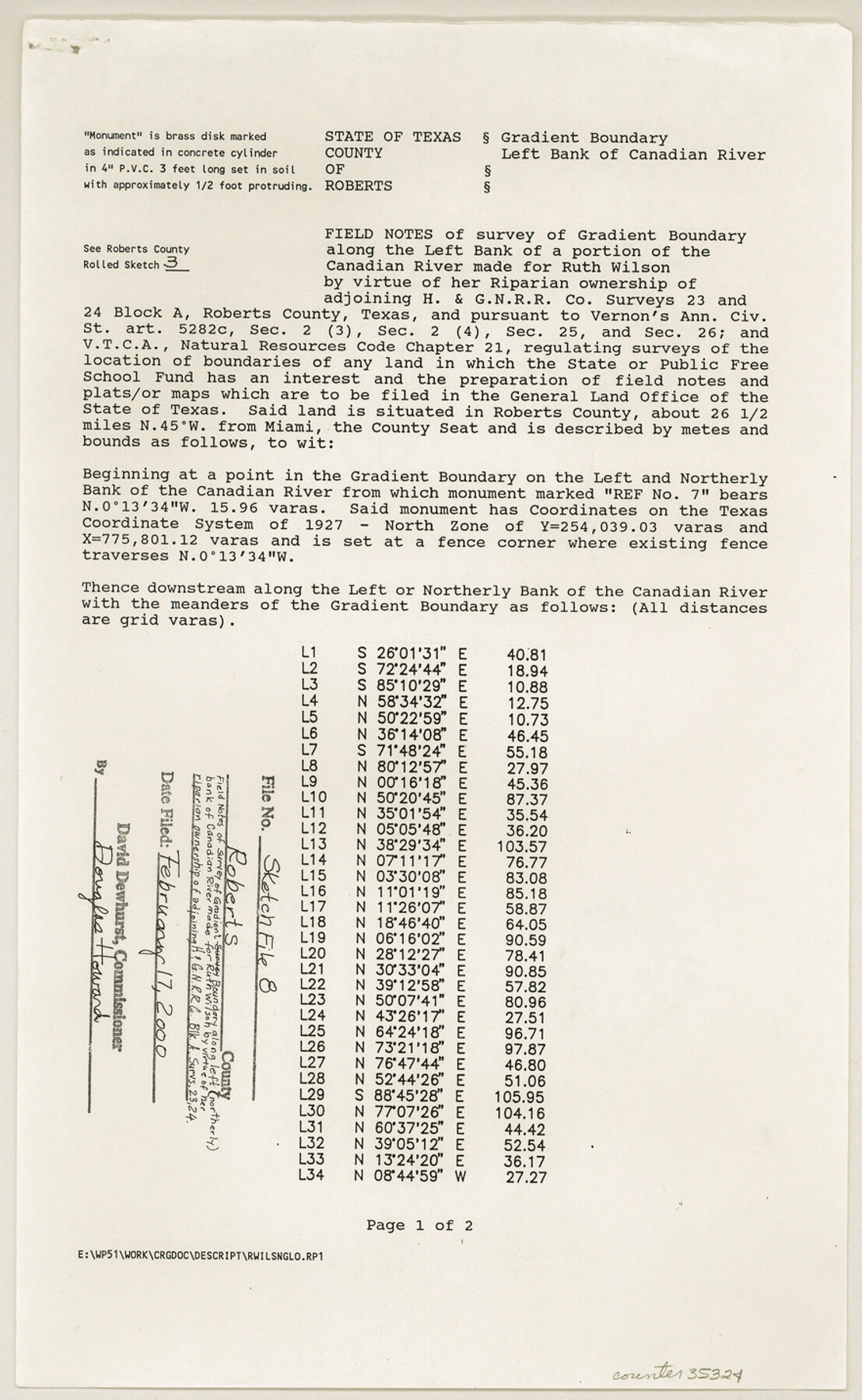
Roberts County Sketch File 8
[Field notes of survey of gradient boundary along the left bank of a portion of the Canadian River made for Ruth Wilson by virtue of her riparian ownership of adjoining H. & G. N. R.R. Co. surveys 23 and 24, Block A]
-
Map/Doc
35324
-
Collection
General Map Collection
-
Object Dates
1992 (Creation Date)
2/17/2000 (File Date)
Sept. 8 - Oct. 22/1992 (Survey Date)
-
People and Organizations
Wm. C. Wilson, Jr. (Surveyor/Engineer)
A.K. "Bud" McMahan (Chainman/Field Personnel)
Gerald McMahan (Chainman/Field Personnel)
Ronald Johnson (Chainman/Field Personnel)
-
Counties
Roberts
-
Subjects
Surveying Sketch File
-
Height x Width
14.3 x 8.8 inches
36.3 x 22.4 cm
-
Medium
paper, print
-
Comments
See Roberts County Rolled Sketch 3 (8354-8359).
-
Features
Canadian River
Related maps
Roberts County Rolled Sketch 3

Print $40.00
- Digital $50.00
Roberts County Rolled Sketch 3
Size 38.0 x 49.7 inches
Map/Doc 8354
Roberts County Rolled Sketch 3

Print $40.00
- Digital $50.00
Roberts County Rolled Sketch 3
Size 38.0 x 49.7 inches
Map/Doc 8355
Roberts County Rolled Sketch 3

Print $40.00
- Digital $50.00
Roberts County Rolled Sketch 3
Size 38.0 x 49.7 inches
Map/Doc 8356
Roberts County Rolled Sketch 3

Print $40.00
- Digital $50.00
Roberts County Rolled Sketch 3
Size 38.0 x 49.7 inches
Map/Doc 8357
Roberts County Rolled Sketch 3

Print $40.00
- Digital $50.00
Roberts County Rolled Sketch 3
Size 38.4 x 50.0 inches
Map/Doc 8358
Roberts County Rolled Sketch 3

Print $40.00
- Digital $50.00
Roberts County Rolled Sketch 3
Size 37.7 x 48.9 inches
Map/Doc 8359
Part of: General Map Collection
County Map of Texas and Indian Territory

Print $20.00
- Digital $50.00
County Map of Texas and Indian Territory
1881
Size 13.1 x 9.9 inches
Map/Doc 94153
McCulloch County Sketch File 6

Print $20.00
- Digital $50.00
McCulloch County Sketch File 6
1893
Size 44.2 x 19.3 inches
Map/Doc 10539
San Jacinto County

Print $40.00
- Digital $50.00
San Jacinto County
1942
Size 49.7 x 44.1 inches
Map/Doc 95633
[Sketch for Mineral Application 16700 - Pecos River Bed]
![2806, [Sketch for Mineral Application 16700 - Pecos River Bed], General Map Collection](https://historictexasmaps.com/wmedia_w700/maps/2806.tif.jpg)
Print $20.00
- Digital $50.00
[Sketch for Mineral Application 16700 - Pecos River Bed]
1927
Size 20.3 x 29.1 inches
Map/Doc 2806
Gaines County Working Sketch 19

Print $20.00
- Digital $50.00
Gaines County Working Sketch 19
1970
Size 46.0 x 37.5 inches
Map/Doc 69319
Kimble County Working Sketch 69

Print $20.00
- Digital $50.00
Kimble County Working Sketch 69
1965
Size 42.4 x 30.5 inches
Map/Doc 70137
Motley County

Print $20.00
- Digital $50.00
Motley County
1966
Size 41.2 x 32.1 inches
Map/Doc 77380
Hamilton County Sketch File 24

Print $20.00
- Digital $50.00
Hamilton County Sketch File 24
1953
Size 23.2 x 22.8 inches
Map/Doc 11619
Map of Potter County

Print $20.00
- Digital $50.00
Map of Potter County
1895
Size 23.6 x 18.4 inches
Map/Doc 4617
Pecos County Rolled Sketch 19 1/2

Print $20.00
- Digital $50.00
Pecos County Rolled Sketch 19 1/2
1885
Size 41.9 x 17.6 inches
Map/Doc 7208
Mason County Boundary File 3

Print $52.00
- Digital $50.00
Mason County Boundary File 3
Size 13.7 x 8.7 inches
Map/Doc 56838
Smith County Rolled Sketch 1

Print $20.00
- Digital $50.00
Smith County Rolled Sketch 1
Size 42.4 x 34.8 inches
Map/Doc 9932
You may also like
Hockley County Sketch File 14

Print $20.00
- Digital $50.00
Hockley County Sketch File 14
1911
Size 26.5 x 17.5 inches
Map/Doc 11773
Terrell County Working Sketch 20

Print $20.00
- Digital $50.00
Terrell County Working Sketch 20
1934
Size 20.5 x 19.4 inches
Map/Doc 62170
Liberty County Rolled Sketch JP2

Print $40.00
- Digital $50.00
Liberty County Rolled Sketch JP2
1935
Size 52.2 x 12.7 inches
Map/Doc 81403
Rusk County Sketch File 35

Print $6.00
Rusk County Sketch File 35
1950
Size 11.3 x 8.8 inches
Map/Doc 35573
Map of Webb County

Print $20.00
- Digital $50.00
Map of Webb County
1878
Size 37.0 x 26.0 inches
Map/Doc 4130
Garza County Sketch File 5a

Print $20.00
- Digital $50.00
Garza County Sketch File 5a
1895
Size 20.7 x 38.2 inches
Map/Doc 10463
Flight Mission No. CUG-3P, Frame 138, Kleberg County

Print $20.00
- Digital $50.00
Flight Mission No. CUG-3P, Frame 138, Kleberg County
1956
Size 18.6 x 22.4 inches
Map/Doc 86273
Bee County Working Sketch 19

Print $20.00
- Digital $50.00
Bee County Working Sketch 19
1980
Size 17.3 x 11.9 inches
Map/Doc 67269
Morris County Rolled Sketch 1

Print $20.00
- Digital $50.00
Morris County Rolled Sketch 1
1942
Size 23.7 x 24.9 inches
Map/Doc 6835
Floyd County Working Sketch 8

Print $20.00
- Digital $50.00
Floyd County Working Sketch 8
1931
Size 20.8 x 15.9 inches
Map/Doc 69187
Crockett County Working Sketch 26

Print $20.00
- Digital $50.00
Crockett County Working Sketch 26
1922
Size 15.3 x 20.3 inches
Map/Doc 68359
Hutchinson County

Print $20.00
- Digital $50.00
Hutchinson County
1898
Size 41.8 x 37.6 inches
Map/Doc 66875