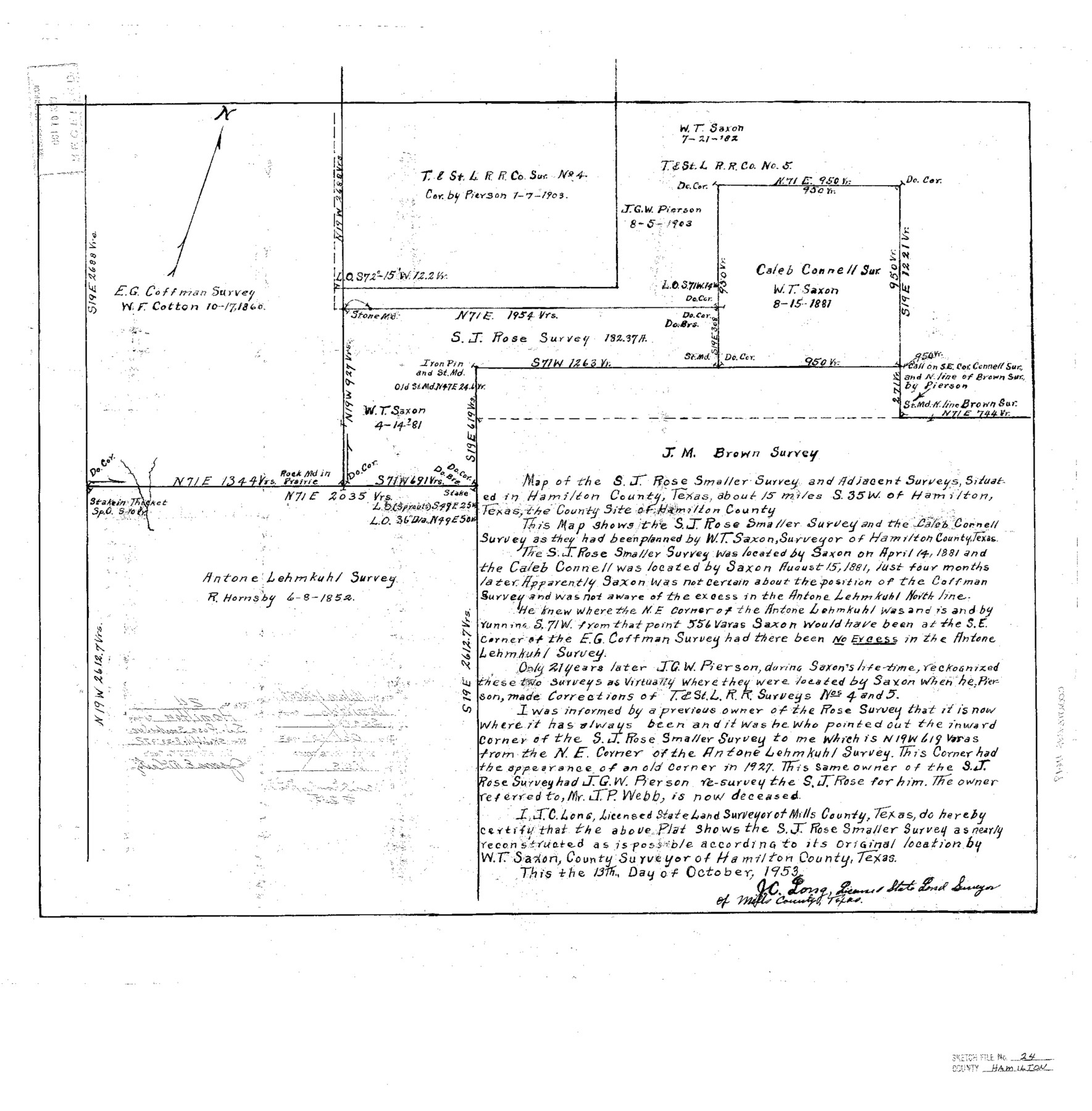
Hamilton County Sketch File 24
S. J. Rose Smaller Surv.
-
Map/Doc
11619
-
Collection
General Map Collection
-
Object Dates
1953/10/13 (Creation Date)
1953/10/19 (File Date)
1881/8/15 (Survey Date)
1881/4/14 (Survey Date)
-
People and Organizations
J.C. Long (Surveyor/Engineer)
W.T. Saxon (Surveyor/Engineer)
-
Counties
Hamilton
-
Subjects
Surveying Sketch File
-
Height x Width
23.2 x 22.8 inches
58.9 x 57.9 cm
-
Medium
paper, photocopy
Part of: General Map Collection
Webb County Sketch File 2-1

Print $6.00
- Digital $50.00
Webb County Sketch File 2-1
1875
Size 9.9 x 8.0 inches
Map/Doc 39710
Houston County Sketch File 38

Print $8.00
- Digital $50.00
Houston County Sketch File 38
Size 12.8 x 8.3 inches
Map/Doc 26821
Three Sitios of Land Granted to Vicente Micheli April 28th 1806

Print $2.00
- Digital $50.00
Three Sitios of Land Granted to Vicente Micheli April 28th 1806
1835
Size 11.8 x 8.1 inches
Map/Doc 170
Brewster County Rolled Sketch 122

Print $20.00
- Digital $50.00
Brewster County Rolled Sketch 122
1974
Size 31.9 x 24.6 inches
Map/Doc 5298
Rusk County Sketch File X

Print $20.00
Rusk County Sketch File X
1844
Size 18.3 x 22.4 inches
Map/Doc 12279
Brazoria County NRC Article 33.136 Sketch 15

Print $44.00
- Digital $50.00
Brazoria County NRC Article 33.136 Sketch 15
2014
Size 39.8 x 30.0 inches
Map/Doc 94698
Travis County Appraisal District Plat Map 1_0202

Print $20.00
- Digital $50.00
Travis County Appraisal District Plat Map 1_0202
Size 21.6 x 26.5 inches
Map/Doc 94206

Fisher County Sketch File 1

Print $20.00
- Digital $50.00
Fisher County Sketch File 1
Size 43.5 x 18.3 inches
Map/Doc 10448
Calhoun County Rolled Sketch 2

Print $20.00
- Digital $50.00
Calhoun County Rolled Sketch 2
Size 23.1 x 22.4 inches
Map/Doc 5360
Amistad International Reservoir on Rio Grande 68

Print $20.00
- Digital $50.00
Amistad International Reservoir on Rio Grande 68
1949
Size 28.4 x 39.4 inches
Map/Doc 73353
Flight Mission No. CRK-8P, Frame 98, Refugio County

Print $20.00
- Digital $50.00
Flight Mission No. CRK-8P, Frame 98, Refugio County
1956
Size 18.2 x 22.0 inches
Map/Doc 86959
You may also like
Cottle County Sketch File 4

Print $16.00
- Digital $50.00
Cottle County Sketch File 4
Size 8.2 x 4.2 inches
Map/Doc 19466
J. B. McCauley Irrigated Farm SW Quarter Section 20, Block E

Print $20.00
- Digital $50.00
J. B. McCauley Irrigated Farm SW Quarter Section 20, Block E
1944
Size 20.7 x 23.5 inches
Map/Doc 92335
[Town Plat of Galveston]
![76258, [Town Plat of Galveston], Texas State Library and Archives](https://historictexasmaps.com/wmedia_w700/maps/76258.tif.jpg)
Print $20.00
[Town Plat of Galveston]
1877
Size 9.1 x 14.5 inches
Map/Doc 76258
Western Waters of the Clear Fork of the Brazos River below Phantom-Hill

Print $20.00
- Digital $50.00
Western Waters of the Clear Fork of the Brazos River below Phantom-Hill
1857
Size 16.0 x 12.5 inches
Map/Doc 4664
Fannin County Rolled Sketch 18G

Print $20.00
- Digital $50.00
Fannin County Rolled Sketch 18G
Size 27.9 x 36.0 inches
Map/Doc 5874
[Surveys in Bexar County]
![93, [Surveys in Bexar County], General Map Collection](https://historictexasmaps.com/wmedia_w700/maps/93.tif.jpg)
Print $2.00
- Digital $50.00
[Surveys in Bexar County]
Size 11.3 x 6.9 inches
Map/Doc 93
General Highway Map, Nueces County, Texas

Print $20.00
General Highway Map, Nueces County, Texas
1961
Size 24.6 x 18.2 inches
Map/Doc 79616
Hidalgo County Working Sketch 5

Print $20.00
- Digital $50.00
Hidalgo County Working Sketch 5
1956
Size 38.1 x 37.9 inches
Map/Doc 66182
Pecos County Working Sketch 80

Print $20.00
- Digital $50.00
Pecos County Working Sketch 80
1960
Size 25.0 x 31.8 inches
Map/Doc 71552
Working Sketch Armstrong County

Print $20.00
- Digital $50.00
Working Sketch Armstrong County
Size 29.3 x 21.2 inches
Map/Doc 90274
Gaines County Sketch File 1

Print $20.00
- Digital $50.00
Gaines County Sketch File 1
Size 19.1 x 30.7 inches
Map/Doc 11521
Plan of the City of Austin

Print $20.00
Plan of the City of Austin
1853
Size 13.9 x 11.5 inches
Map/Doc 76207