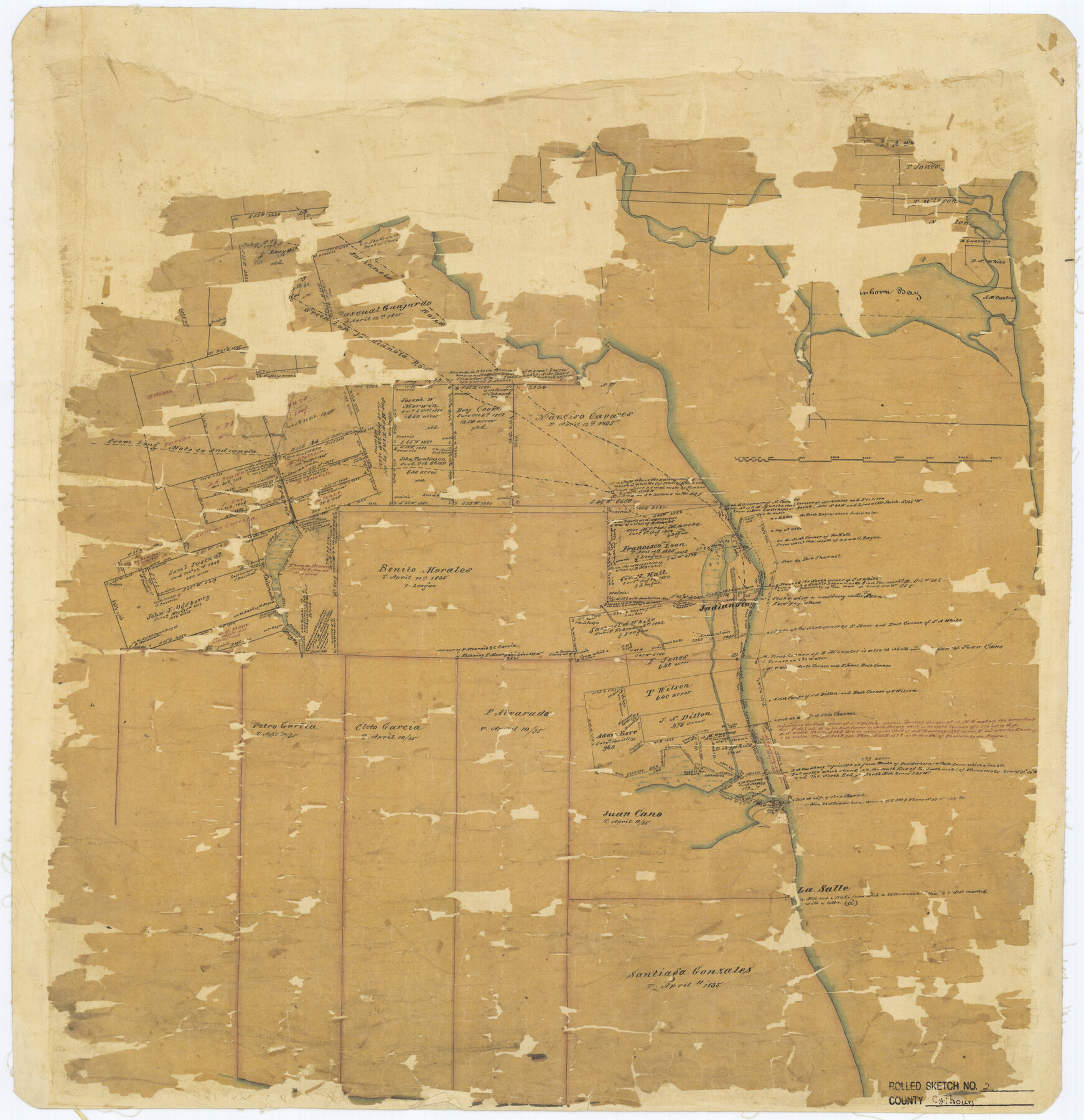
Calhoun County Rolled Sketch 2
[Sketch of surveys near Indianola]
-
Map/Doc
5360
-
Collection
General Map Collection
-
Counties
Calhoun
-
Subjects
Surveying Rolled Sketch
-
Height x Width
23.1 x 22.4 inches
58.7 x 56.9 cm
-
Medium
paper, manuscript
Part of: General Map Collection
East Part of Brewster Co.

Print $40.00
- Digital $50.00
East Part of Brewster Co.
1952
Size 48.8 x 31.9 inches
Map/Doc 1785
Crosby County Sketch File 24

Print $4.00
- Digital $50.00
Crosby County Sketch File 24
Size 7.3 x 8.8 inches
Map/Doc 20091
Gray's New Map of Texas and the Indian Territory

Print $20.00
- Digital $50.00
Gray's New Map of Texas and the Indian Territory
1876
Size 17.6 x 28.6 inches
Map/Doc 97282
Galveston County Rolled Sketch 43B

Print $20.00
- Digital $50.00
Galveston County Rolled Sketch 43B
Size 27.3 x 16.2 inches
Map/Doc 76006
Map of Georgia, Florida, Alabama, Mississippi and Tennessee engraved to illustrate Mitchell's new intermediate geography

Print $20.00
- Digital $50.00
Map of Georgia, Florida, Alabama, Mississippi and Tennessee engraved to illustrate Mitchell's new intermediate geography
1885
Size 12.2 x 9.0 inches
Map/Doc 93518
Scurry County Working Sketch 5

Print $40.00
- Digital $50.00
Scurry County Working Sketch 5
1950
Size 72.5 x 27.8 inches
Map/Doc 63834
Lavaca County Sketch File 20

Print $8.00
- Digital $50.00
Lavaca County Sketch File 20
Size 10.0 x 8.0 inches
Map/Doc 29650
Duval County Sketch File 19

Print $4.00
- Digital $50.00
Duval County Sketch File 19
1880
Size 10.3 x 8.2 inches
Map/Doc 21316
Schleicher County Sketch File 18

Print $20.00
- Digital $50.00
Schleicher County Sketch File 18
Size 15.1 x 25.0 inches
Map/Doc 12300
Stephens County

Print $20.00
- Digital $50.00
Stephens County
1940
Size 40.3 x 38.9 inches
Map/Doc 77426
Frio County Sketch File 4a

Print $6.00
- Digital $50.00
Frio County Sketch File 4a
1883
Size 8.3 x 6.7 inches
Map/Doc 23113

You may also like
Leon County Sketch File 14

Print $6.00
- Digital $50.00
Leon County Sketch File 14
Size 13.2 x 8.8 inches
Map/Doc 29767
Sutton County Sketch File 27B

Print $20.00
- Digital $50.00
Sutton County Sketch File 27B
Size 19.1 x 14.6 inches
Map/Doc 12384
Harris County Sketch File 71a

Print $24.00
- Digital $50.00
Harris County Sketch File 71a
1941
Size 11.4 x 8.9 inches
Map/Doc 25525
Pecos County Rolled Sketch 32A

Print $7.00
- Digital $50.00
Pecos County Rolled Sketch 32A
1890
Size 10.5 x 15.2 inches
Map/Doc 48096
[Surveys in Polk County]
![69751, [Surveys in Polk County], General Map Collection](https://historictexasmaps.com/wmedia_w700/maps/69751.tif.jpg)
Print $2.00
- Digital $50.00
[Surveys in Polk County]
1847
Size 4.6 x 6.6 inches
Map/Doc 69751
[Sketch of Blocks D5-D8]
![93046, [Sketch of Blocks D5-D8], Twichell Survey Records](https://historictexasmaps.com/wmedia_w700/maps/93046-1.tif.jpg)
Print $20.00
- Digital $50.00
[Sketch of Blocks D5-D8]
Size 43.1 x 28.3 inches
Map/Doc 93046
San Jacinto County Sketch File 20A

Print $6.00
San Jacinto County Sketch File 20A
1939
Size 13.9 x 8.9 inches
Map/Doc 35731
Dallam Co. Texas, Standard Single County Oil Development Survey

Print $20.00
- Digital $50.00
Dallam Co. Texas, Standard Single County Oil Development Survey
Size 20.7 x 15.8 inches
Map/Doc 90583
National Parks, Monuments and Shrines of the United States and Canada

National Parks, Monuments and Shrines of the United States and Canada
1958
Size 25.5 x 19.5 inches
Map/Doc 92378
The Republic County of Washington. February 4, 1840

Print $20.00
The Republic County of Washington. February 4, 1840
2020
Size 20.3 x 21.7 inches
Map/Doc 96304
Tyler County Sketch File 15

Print $6.00
- Digital $50.00
Tyler County Sketch File 15
1857
Size 10.4 x 7.5 inches
Map/Doc 38658
Howard County Sketch File 10

Print $20.00
- Digital $50.00
Howard County Sketch File 10
Size 22.5 x 22.0 inches
Map/Doc 11798