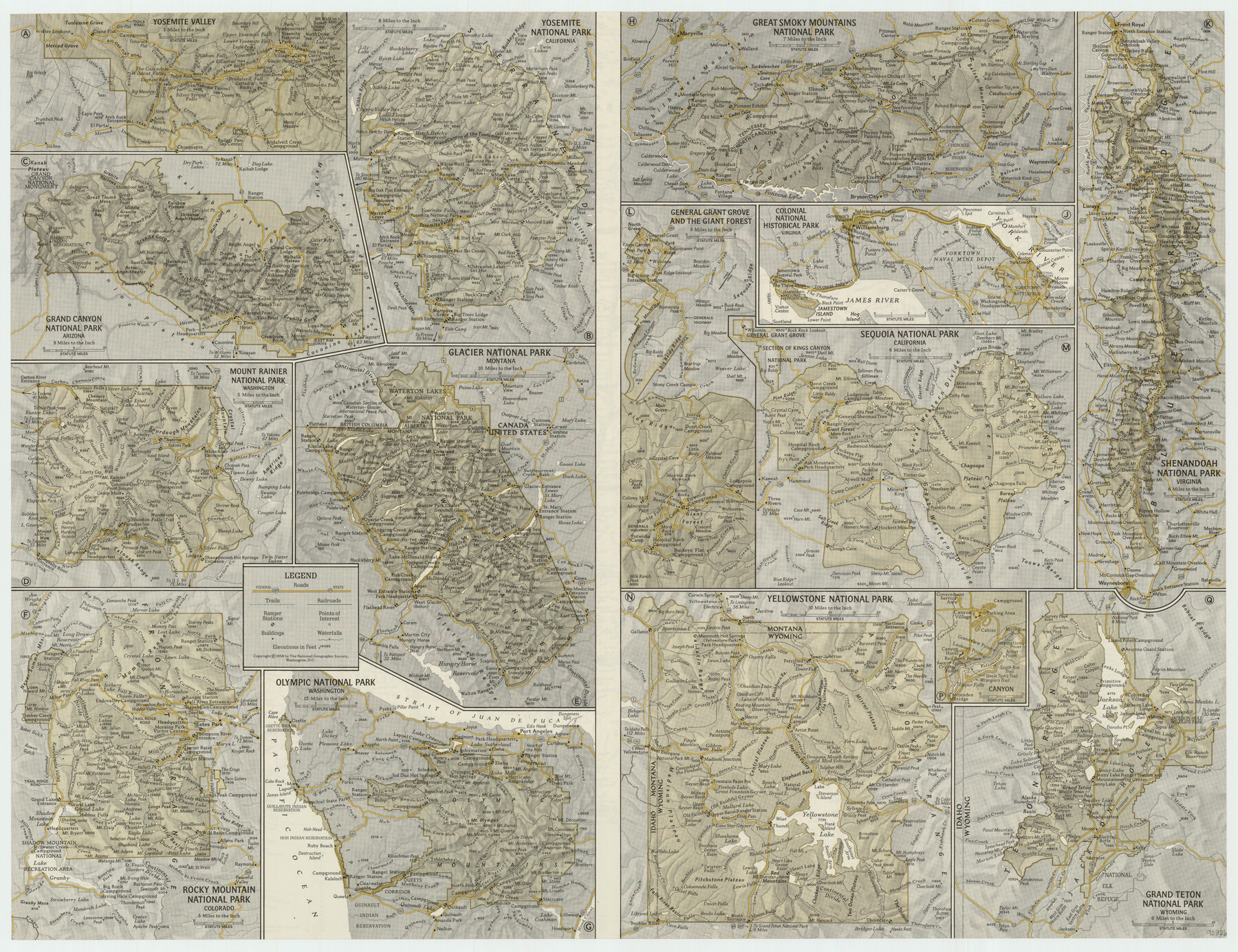
National Parks, Monuments and Shrines of the United States and Canada
-
Map/Doc
92378
-
Collection
Twichell Survey Records
-
Object Dates
5/1958 (Creation Date)
-
People and Organizations
National Geographic Society (Compiler)
-
Subjects
United States
-
Height x Width
25.5 x 19.5 inches
64.8 x 49.5 cm
-
Comments
For research only. Not available for duplication from the GLO.
Part of: Twichell Survey Records
Dawson County, Texas

Print $20.00
- Digital $50.00
Dawson County, Texas
Size 16.0 x 18.1 inches
Map/Doc 92620
[C. C. S. D. & R. G. N. G. RR. Co. Block G, Waxahachie Tap RR. Co. Block G and D. & W. RR. Co. Block H]
![90859, [C. C. S. D. & R. G. N. G. RR. Co. Block G, Waxahachie Tap RR. Co. Block G and D. & W. RR. Co. Block H], Twichell Survey Records](https://historictexasmaps.com/wmedia_w700/maps/90859-2.tif.jpg)
Print $20.00
- Digital $50.00
[C. C. S. D. & R. G. N. G. RR. Co. Block G, Waxahachie Tap RR. Co. Block G and D. & W. RR. Co. Block H]
1915
Size 22.6 x 11.4 inches
Map/Doc 90859
N. F. Cleavinger

Print $3.00
- Digital $50.00
N. F. Cleavinger
Size 16.5 x 10.6 inches
Map/Doc 92406
Map of T. C. Spearman's Lands in Gaines, Terry & Yoakum Counties, Texas

Print $20.00
- Digital $50.00
Map of T. C. Spearman's Lands in Gaines, Terry & Yoakum Counties, Texas
1917
Size 46.0 x 37.6 inches
Map/Doc 89842
League 206, Ochiltree County School Land, Bailey and Lamb Counties, Texas

Print $20.00
- Digital $50.00
League 206, Ochiltree County School Land, Bailey and Lamb Counties, Texas
1954
Size 36.9 x 25.0 inches
Map/Doc 92537
[Sketch showing counties along Texas-New Mexico border]
![91986, [Sketch showing counties along Texas-New Mexico border], Twichell Survey Records](https://historictexasmaps.com/wmedia_w700/maps/91986-1.tif.jpg)
Print $3.00
- Digital $50.00
[Sketch showing counties along Texas-New Mexico border]
Size 11.0 x 16.7 inches
Map/Doc 91986
[John Gibbs and surrounding surveys]
![91161, [John Gibbs and surrounding surveys], Twichell Survey Records](https://historictexasmaps.com/wmedia_w700/maps/91161-1.tif.jpg)
Print $20.00
- Digital $50.00
[John Gibbs and surrounding surveys]
Size 18.8 x 22.8 inches
Map/Doc 91161
M. C. Lindsey's Subdivision of Block 20 College Addition to Lamesa, Texas

Print $20.00
- Digital $50.00
M. C. Lindsey's Subdivision of Block 20 College Addition to Lamesa, Texas
1953
Size 9.6 x 18.2 inches
Map/Doc 92589
Blocks 14, 15, and 16 Capitol Syndicate Subdivision of Capitol Land Reservation Leagues

Print $20.00
- Digital $50.00
Blocks 14, 15, and 16 Capitol Syndicate Subdivision of Capitol Land Reservation Leagues
1907
Size 26.2 x 37.1 inches
Map/Doc 90712
Working Sketch Armstrong County

Print $20.00
- Digital $50.00
Working Sketch Armstrong County
Size 29.3 x 21.2 inches
Map/Doc 90274
Map No. 1 - Surveys Located in 1881 as they appear on the ground

Print $20.00
- Digital $50.00
Map No. 1 - Surveys Located in 1881 as they appear on the ground
Size 29.6 x 18.8 inches
Map/Doc 91889
[H. & G. N. Block 1]
![90940, [H. & G. N. Block 1], Twichell Survey Records](https://historictexasmaps.com/wmedia_w700/maps/90940-1.tif.jpg)
Print $20.00
- Digital $50.00
[H. & G. N. Block 1]
1873
Size 17.3 x 14.2 inches
Map/Doc 90940
You may also like
Donley County Sketch File 28

Print $40.00
- Digital $50.00
Donley County Sketch File 28
Size 25.7 x 9.1 inches
Map/Doc 21266
Hudspeth County Sketch File 11b

Print $16.00
- Digital $50.00
Hudspeth County Sketch File 11b
Size 14.2 x 8.9 inches
Map/Doc 26914
Collingsworth County Sketch File 7

Print $10.00
- Digital $50.00
Collingsworth County Sketch File 7
1915
Size 11.4 x 9.0 inches
Map/Doc 18884
Brewster County Sketch File S-29

Print $44.00
- Digital $50.00
Brewster County Sketch File S-29
1971
Size 11.1 x 8.7 inches
Map/Doc 15846
United States Great Lakes and adjacent waterways

Print $20.00
- Digital $50.00
United States Great Lakes and adjacent waterways
Size 20.8 x 42.7 inches
Map/Doc 76122
Wichita County Sketch File 9a

Print $4.00
- Digital $50.00
Wichita County Sketch File 9a
Size 10.7 x 8.2 inches
Map/Doc 40052
Blanco County Sketch File 50

Print $6.00
- Digital $50.00
Blanco County Sketch File 50
1995
Size 11.5 x 8.8 inches
Map/Doc 14695
Map of Jack County

Print $20.00
- Digital $50.00
Map of Jack County
Size 18.4 x 15.9 inches
Map/Doc 3702
Hudspeth County Sketch File 10

Print $4.00
- Digital $50.00
Hudspeth County Sketch File 10
1900
Size 11.2 x 8.8 inches
Map/Doc 26899
Lubbock Cemetery

Print $40.00
- Digital $50.00
Lubbock Cemetery
Size 42.2 x 53.7 inches
Map/Doc 89912
Crockett County Working Sketch 27

Print $20.00
- Digital $50.00
Crockett County Working Sketch 27
1923
Size 29.4 x 27.2 inches
Map/Doc 68360
San Saba County Working Sketch 11

Print $20.00
- Digital $50.00
San Saba County Working Sketch 11
1989
Size 30.3 x 38.2 inches
Map/Doc 63799