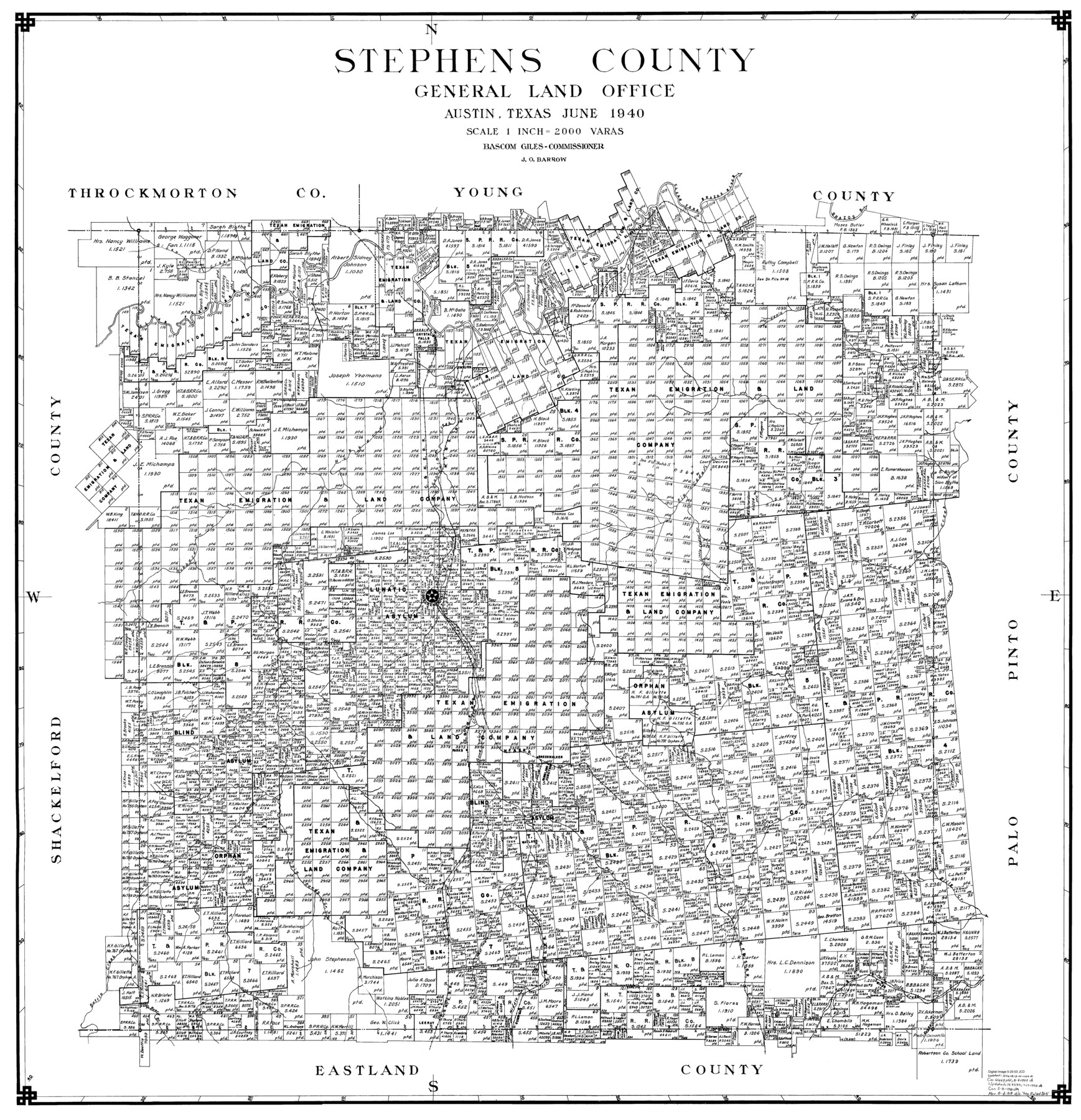
Stephens County
-
Map/Doc
77426
-
Collection
General Map Collection
-
Object Dates
1940 (Creation Date)
-
People and Organizations
Eltea Armstrong (Draftsman)
J.O. Barrow (Compiler)
-
Counties
Stephens
-
Subjects
County
-
Height x Width
40.3 x 38.9 inches
102.4 x 98.8 cm
Part of: General Map Collection
Crockett County Rolled Sketch 88D

Print $40.00
- Digital $50.00
Crockett County Rolled Sketch 88D
Size 43.2 x 52.0 inches
Map/Doc 8729
Aransas Pass to Baffin Bay

Print $20.00
- Digital $50.00
Aransas Pass to Baffin Bay
1966
Size 42.3 x 34.9 inches
Map/Doc 73416
Baylor County Sketch File 1

Print $6.00
- Digital $50.00
Baylor County Sketch File 1
Size 17.5 x 11.4 inches
Map/Doc 14117
Sutton County Sketch File 7

Print $4.00
- Digital $50.00
Sutton County Sketch File 7
Size 10.6 x 8.7 inches
Map/Doc 37365
Edwards County Rolled Sketch 7

Print $20.00
- Digital $50.00
Edwards County Rolled Sketch 7
1881
Size 24.4 x 23.2 inches
Map/Doc 5800
Map showing survey for proposed ship channel from Brownsville to Brazos Santiago Pass

Print $20.00
- Digital $50.00
Map showing survey for proposed ship channel from Brownsville to Brazos Santiago Pass
1912
Size 18.1 x 27.7 inches
Map/Doc 72904
Limestone County Sketch File 25

Print $20.00
- Digital $50.00
Limestone County Sketch File 25
Size 25.1 x 32.8 inches
Map/Doc 12003
Denton County Working Sketch 24

Print $20.00
- Digital $50.00
Denton County Working Sketch 24
1989
Size 22.2 x 30.0 inches
Map/Doc 68629
Pecos County Working Sketch 90

Print $40.00
- Digital $50.00
Pecos County Working Sketch 90
1964
Size 65.3 x 26.6 inches
Map/Doc 71562
Dimmit County Sketch File 55

Print $20.00
- Digital $50.00
Dimmit County Sketch File 55
1926
Size 23.1 x 15.7 inches
Map/Doc 11359
Flight Mission No. DAG-23K, Frame 151, Matagorda County

Print $20.00
- Digital $50.00
Flight Mission No. DAG-23K, Frame 151, Matagorda County
1953
Size 15.9 x 15.8 inches
Map/Doc 86499
Marion County Working Sketch 17

Print $20.00
- Digital $50.00
Marion County Working Sketch 17
1955
Size 31.1 x 26.1 inches
Map/Doc 70793
You may also like
The History of Texas; or the Emigrant's, Farmer's, and Politician's Guide to the Character, Climate, Soil and Productions of that Country: Geographically Arranged from Personal Observation and Experience

The History of Texas; or the Emigrant's, Farmer's, and Politician's Guide to the Character, Climate, Soil and Productions of that Country: Geographically Arranged from Personal Observation and Experience
1836
Size 7.6 x 9.1 inches
Map/Doc 94038
Flight Mission No. CZW-3R, Frame 82

Print $20.00
- Digital $50.00
Flight Mission No. CZW-3R, Frame 82
1956
Size 18.6 x 22.3 inches
Map/Doc 85240
[Sabine County School Land and Blocks A4, W, and DT]
![92697, [Sabine County School Land and Blocks A4, W, and DT], Twichell Survey Records](https://historictexasmaps.com/wmedia_w700/maps/92697-1.tif.jpg)
Print $20.00
- Digital $50.00
[Sabine County School Land and Blocks A4, W, and DT]
Size 18.9 x 15.6 inches
Map/Doc 92697
Amistad International Reservoir on Rio Grande 90

Print $20.00
- Digital $50.00
Amistad International Reservoir on Rio Grande 90
1950
Size 28.5 x 39.7 inches
Map/Doc 75520
Flight Mission No. CRC-6R, Frame 39, Chambers County

Print $20.00
- Digital $50.00
Flight Mission No. CRC-6R, Frame 39, Chambers County
1956
Size 18.7 x 22.5 inches
Map/Doc 84972
Hudspeth County Rolled Sketch 25

Print $20.00
- Digital $50.00
Hudspeth County Rolled Sketch 25
1909
Size 18.0 x 20.7 inches
Map/Doc 6245
Bee County Sketch File 4

Print $6.00
- Digital $50.00
Bee County Sketch File 4
1858
Size 16.7 x 10.0 inches
Map/Doc 14268
Fractional Township No. 7 South Range No. 2 West of the Indian Meridian, Indian Territory

Print $20.00
- Digital $50.00
Fractional Township No. 7 South Range No. 2 West of the Indian Meridian, Indian Territory
1898
Size 19.2 x 24.4 inches
Map/Doc 75195
Gregg County Sketch File 17

Print $10.00
- Digital $50.00
Gregg County Sketch File 17
1874
Size 10.3 x 8.2 inches
Map/Doc 24621
Harris County Rolled Sketch 91

Print $407.00
- Digital $50.00
Harris County Rolled Sketch 91
1981
Size 31.0 x 24.3 inches
Map/Doc 6130
Terrell County Sketch File 28

Print $20.00
- Digital $50.00
Terrell County Sketch File 28
1939
Size 18.3 x 22.8 inches
Map/Doc 12425
Ector County Working Sketch 7

Print $40.00
- Digital $50.00
Ector County Working Sketch 7
1941
Size 48.5 x 29.3 inches
Map/Doc 68850