Palo Pinto County Sketch File B

Print $20.00
- Digital $50.00
Palo Pinto County Sketch File B
Size: 45.3 x 45.5 inches
10566
Stephens County Sketch File 16

Print $40.00
- Digital $50.00
Stephens County Sketch File 16
Size: 38.2 x 72.1 inches
10608
Palo Pinto County Sketch File 21

Print $20.00
- Digital $50.00
Palo Pinto County Sketch File 21
1896
Size: 18.5 x 17.5 inches
12133
Stephens County Sketch File 1

Print $20.00
- Digital $50.00
Stephens County Sketch File 1
1857
Size: 19.2 x 16.1 inches
12347
Stephens County Sketch File 1B

Print $20.00
- Digital $50.00
Stephens County Sketch File 1B
Size: 12.9 x 28.2 inches
12348
Stephens County Sketch File 20

Print $20.00
- Digital $50.00
Stephens County Sketch File 20
Size: 19.2 x 36.7 inches
12350
Stephens County Sketch File 21

Print $20.00
- Digital $50.00
Stephens County Sketch File 21
Size: 25.3 x 19.6 inches
12351
Stephens County Sketch File 22

Print $40.00
- Digital $50.00
Stephens County Sketch File 22
1919
Size: 22.1 x 28.8 inches
12352
Stephens County Sketch File 24

Print $5.00
- Digital $50.00
Stephens County Sketch File 24
1952
Size: 24.5 x 32.5 inches
12354
Map of Stephens County

Print $20.00
- Digital $50.00
Map of Stephens County
1897
Size: 43.2 x 37.6 inches
16818
Map of The Surveyed Part of Peters Colony Texas

Print $40.00
- Digital $50.00
Map of The Surveyed Part of Peters Colony Texas
1854
Size: 53.5 x 65.9 inches
1967
Sketch showing the Connnecting Lines run by Olliver Hedgcoxe for the Texan Emigration and Land Company connecting their Surveys made by them in Peters' Colony, Texas

Print $40.00
- Digital $50.00
Sketch showing the Connnecting Lines run by Olliver Hedgcoxe for the Texan Emigration and Land Company connecting their Surveys made by them in Peters' Colony, Texas
1854
Size: 45.8 x 61.9 inches
1969
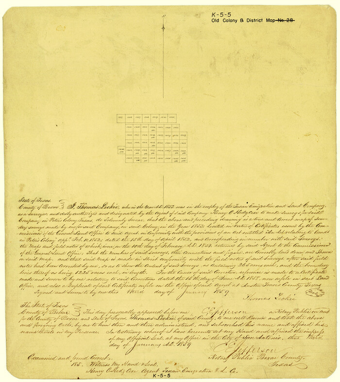
[Surveys made in Peters Colony by Thomas Leckie]
Print $20.00
- Digital $50.00
[Surveys made in Peters Colony by Thomas Leckie]
1859
Size: 15.1 x 13.4 inches
1984
Eastland County Sketch File 7

Print $4.00
- Digital $50.00
Eastland County Sketch File 7
1872
Size: 12.6 x 8.5 inches
21574
Eastland County Sketch File 15

Print $2.00
- Digital $50.00
Eastland County Sketch File 15
1882
Size: 11.4 x 8.6 inches
21599
Eastland County Sketch File 17

Print $18.00
- Digital $50.00
Eastland County Sketch File 17
1918
Size: 13.6 x 8.9 inches
21600
Eastland County Sketch File 19

Print $2.00
- Digital $50.00
Eastland County Sketch File 19
1983
Size: 14.3 x 9.0 inches
21608
Map of Asylum & University lands situated on the waters of Hubbards Creek

Print $20.00
- Digital $50.00
Map of Asylum & University lands situated on the waters of Hubbards Creek
1857
Size: 21.2 x 28.5 inches
2491
Palo Pinto County Sketch File A

Print $6.00
- Digital $50.00
Palo Pinto County Sketch File A
Size: 8.7 x 4.1 inches
33389
Palo Pinto County Sketch File 8

Print $40.00
- Digital $50.00
Palo Pinto County Sketch File 8
Size: 15.3 x 15.6 inches
33400
Callahan County Sketch File 6

Print $42.00
- Digital $50.00
Callahan County Sketch File 6
1858
Size: 8.2 x 6.4 inches
35859
Stephens County Sketch File 2

Print $4.00
- Digital $50.00
Stephens County Sketch File 2
1870
Size: 12.9 x 8.2 inches
37013
Stephens County Sketch File 3

Print $4.00
- Digital $50.00
Stephens County Sketch File 3
Size: 8.6 x 10.6 inches
37015
Stephens County Sketch File 4

Print $4.00
- Digital $50.00
Stephens County Sketch File 4
Size: 7.9 x 12.1 inches
37017
Stephens County Sketch File 5

Print $6.00
- Digital $50.00
Stephens County Sketch File 5
Size: 10.0 x 13.3 inches
37019
Stephens County Sketch File 6

Print $4.00
- Digital $50.00
Stephens County Sketch File 6
Size: 9.1 x 9.1 inches
37021
Stephens County Sketch File 6a

Print $4.00
- Digital $50.00
Stephens County Sketch File 6a
Size: 12.4 x 8.4 inches
37023
Stephens County Sketch File 7

Print $4.00
- Digital $50.00
Stephens County Sketch File 7
1875
Size: 8.1 x 9.9 inches
37025
Stephens County Sketch File 8

Print $40.00
- Digital $50.00
Stephens County Sketch File 8
1879
Size: 13.5 x 14.2 inches
37027
Palo Pinto County Sketch File B
Print $20.00
- Digital $50.00
Palo Pinto County Sketch File B
-
Size
45.3 x 45.5 inches
-
Map/Doc
10566
Stephens County Sketch File 16
Print $40.00
- Digital $50.00
Stephens County Sketch File 16
-
Size
38.2 x 72.1 inches
-
Map/Doc
10608
Palo Pinto County Sketch File 21
Print $20.00
- Digital $50.00
Palo Pinto County Sketch File 21
1896
-
Size
18.5 x 17.5 inches
-
Map/Doc
12133
-
Creation Date
1896
Stephens County Sketch File 1
Print $20.00
- Digital $50.00
Stephens County Sketch File 1
1857
-
Size
19.2 x 16.1 inches
-
Map/Doc
12347
-
Creation Date
1857
Stephens County Sketch File 1B
Print $20.00
- Digital $50.00
Stephens County Sketch File 1B
-
Size
12.9 x 28.2 inches
-
Map/Doc
12348
Stephens County Sketch File 20
Print $20.00
- Digital $50.00
Stephens County Sketch File 20
-
Size
19.2 x 36.7 inches
-
Map/Doc
12350
Stephens County Sketch File 21
Print $20.00
- Digital $50.00
Stephens County Sketch File 21
-
Size
25.3 x 19.6 inches
-
Map/Doc
12351
Stephens County Sketch File 22
Print $40.00
- Digital $50.00
Stephens County Sketch File 22
1919
-
Size
22.1 x 28.8 inches
-
Map/Doc
12352
-
Creation Date
1919
Stephens County Sketch File 24
Print $5.00
- Digital $50.00
Stephens County Sketch File 24
1952
-
Size
24.5 x 32.5 inches
-
Map/Doc
12354
-
Creation Date
1952
Map of Stephens County
Print $20.00
- Digital $50.00
Map of Stephens County
1897
-
Size
43.2 x 37.6 inches
-
Map/Doc
16818
-
Creation Date
1897
Milam [District]
![1948, Milam [District], General Map Collection](https://historictexasmaps.com/wmedia_w700/maps/1948.tif.jpg)
Print $40.00
- Digital $50.00
Milam [District]
1850
-
Size
60.8 x 46.4 inches
-
Map/Doc
1948
-
Creation Date
1850
Map of The Surveyed Part of Peters Colony Texas
Print $40.00
- Digital $50.00
Map of The Surveyed Part of Peters Colony Texas
1854
-
Size
53.5 x 65.9 inches
-
Map/Doc
1967
-
Creation Date
1854
Sketch showing the Connnecting Lines run by Olliver Hedgcoxe for the Texan Emigration and Land Company connecting their Surveys made by them in Peters' Colony, Texas
Print $40.00
- Digital $50.00
Sketch showing the Connnecting Lines run by Olliver Hedgcoxe for the Texan Emigration and Land Company connecting their Surveys made by them in Peters' Colony, Texas
1854
-
Size
45.8 x 61.9 inches
-
Map/Doc
1969
-
Creation Date
1854
[Surveys made in Peters Colony by Thomas Leckie]
Print $20.00
- Digital $50.00
[Surveys made in Peters Colony by Thomas Leckie]
1859
-
Size
15.1 x 13.4 inches
-
Map/Doc
1984
-
Creation Date
1859
Eastland County Sketch File 7
Print $4.00
- Digital $50.00
Eastland County Sketch File 7
1872
-
Size
12.6 x 8.5 inches
-
Map/Doc
21574
-
Creation Date
1872
Eastland County Sketch File 15
Print $2.00
- Digital $50.00
Eastland County Sketch File 15
1882
-
Size
11.4 x 8.6 inches
-
Map/Doc
21599
-
Creation Date
1882
Eastland County Sketch File 17
Print $18.00
- Digital $50.00
Eastland County Sketch File 17
1918
-
Size
13.6 x 8.9 inches
-
Map/Doc
21600
-
Creation Date
1918
Eastland County Sketch File 19
Print $2.00
- Digital $50.00
Eastland County Sketch File 19
1983
-
Size
14.3 x 9.0 inches
-
Map/Doc
21608
-
Creation Date
1983
Map of Asylum & University lands situated on the waters of Hubbards Creek
Print $20.00
- Digital $50.00
Map of Asylum & University lands situated on the waters of Hubbards Creek
1857
-
Size
21.2 x 28.5 inches
-
Map/Doc
2491
-
Creation Date
1857
Palo Pinto County Sketch File A
Print $6.00
- Digital $50.00
Palo Pinto County Sketch File A
-
Size
8.7 x 4.1 inches
-
Map/Doc
33389
Palo Pinto County Sketch File 8
Print $40.00
- Digital $50.00
Palo Pinto County Sketch File 8
-
Size
15.3 x 15.6 inches
-
Map/Doc
33400
Callahan County Sketch File 6
Print $42.00
- Digital $50.00
Callahan County Sketch File 6
1858
-
Size
8.2 x 6.4 inches
-
Map/Doc
35859
-
Creation Date
1858
Stephens County Sketch File 2
Print $4.00
- Digital $50.00
Stephens County Sketch File 2
1870
-
Size
12.9 x 8.2 inches
-
Map/Doc
37013
-
Creation Date
1870
Stephens County Sketch File 3
Print $4.00
- Digital $50.00
Stephens County Sketch File 3
-
Size
8.6 x 10.6 inches
-
Map/Doc
37015
Stephens County Sketch File 4
Print $4.00
- Digital $50.00
Stephens County Sketch File 4
-
Size
7.9 x 12.1 inches
-
Map/Doc
37017
Stephens County Sketch File 5
Print $6.00
- Digital $50.00
Stephens County Sketch File 5
-
Size
10.0 x 13.3 inches
-
Map/Doc
37019
Stephens County Sketch File 6
Print $4.00
- Digital $50.00
Stephens County Sketch File 6
-
Size
9.1 x 9.1 inches
-
Map/Doc
37021
Stephens County Sketch File 6a
Print $4.00
- Digital $50.00
Stephens County Sketch File 6a
-
Size
12.4 x 8.4 inches
-
Map/Doc
37023
Stephens County Sketch File 7
Print $4.00
- Digital $50.00
Stephens County Sketch File 7
1875
-
Size
8.1 x 9.9 inches
-
Map/Doc
37025
-
Creation Date
1875
Stephens County Sketch File 8
Print $40.00
- Digital $50.00
Stephens County Sketch File 8
1879
-
Size
13.5 x 14.2 inches
-
Map/Doc
37027
-
Creation Date
1879