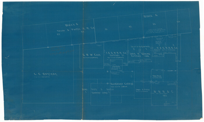
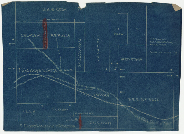
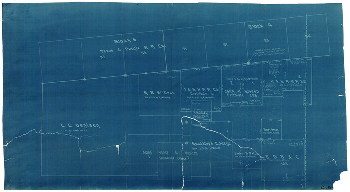
[Texas & Pacific RR. Co. Blocks 6 and 4, L. C. Denison, Guadalupe College and vicinity]
Print $20.00
- Digital $50.00
[Texas & Pacific RR. Co. Blocks 6 and 4, L. C. Denison, Guadalupe College and vicinity]
Size: 32.5 x 19.8 inches
92133
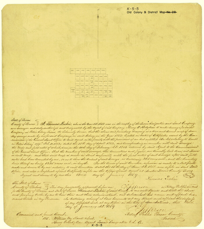
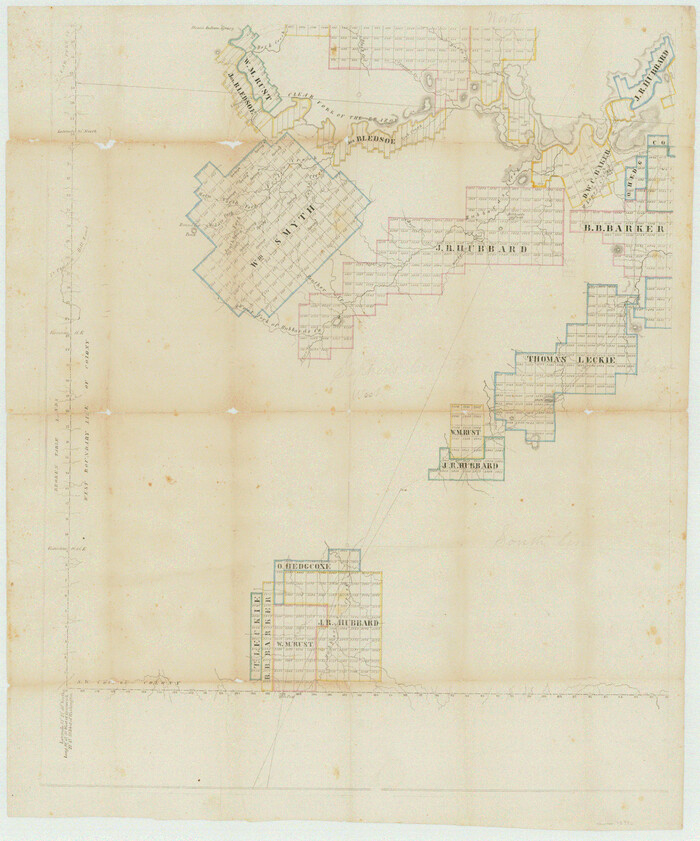
[Surveys made in Peters Colony by Thomas Leckie]
Print $20.00
- Digital $50.00
[Surveys made in Peters Colony by Thomas Leckie]
1859
Size: 15.1 x 13.4 inches
1984
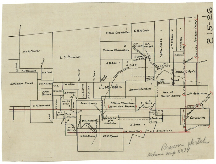
[Surveys in Southeast part of Stephens County]
Print $2.00
- Digital $50.00
[Surveys in Southeast part of Stephens County]
Size: 9.1 x 7.0 inches
91909
[Surveys Adjacent to W. D. Twichell's near Palo Pinto Creek]
Print $2.00
- Digital $50.00
[Surveys Adjacent to W. D. Twichell's near Palo Pinto Creek]
Size: 8.4 x 6.6 inches
92101
[Surveys Adjacent to W. D. Twichell's near Palo Pinto Creek]
Print $2.00
- Digital $50.00
[Surveys Adjacent to W. D. Twichell's near Palo Pinto Creek]
Size: 8.4 x 6.2 inches
92102
[Southern Part of County]
Print $2.00
- Digital $50.00
[Southern Part of County]
Size: 9.8 x 7.6 inches
91905
[Southeast part of Stephens County]
Print $20.00
- Digital $50.00
[Southeast part of Stephens County]
Size: 37.2 x 32.7 inches
91844
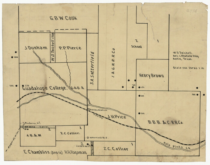
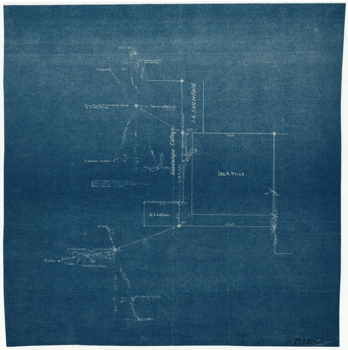
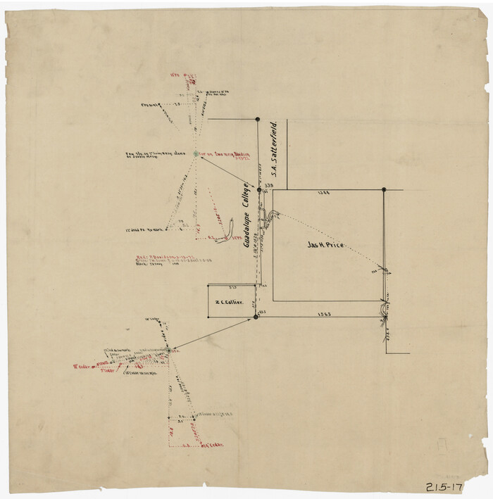
[Southeast part of County near Jas. H. Price Survey]
Print $20.00
- Digital $50.00
[Southeast part of County near Jas. H. Price Survey]
Size: 19.3 x 19.3 inches
91888
[Southeast part of County near Jas. H. Price Survey]
Print $20.00
- Digital $50.00
[Southeast part of County near Jas. H. Price Survey]
Size: 19.9 x 20.0 inches
91915
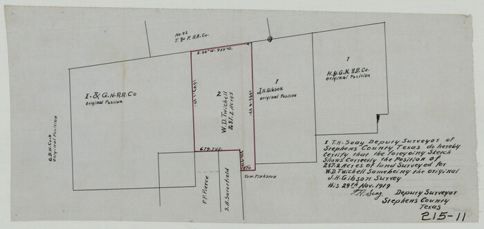
[Sketch showing position of 287.2 acres of land surveyed for W. D. Twichell]
Print $2.00
- Digital $50.00
[Sketch showing position of 287.2 acres of land surveyed for W. D. Twichell]
1919
Size: 15.2 x 7.3 inches
91904
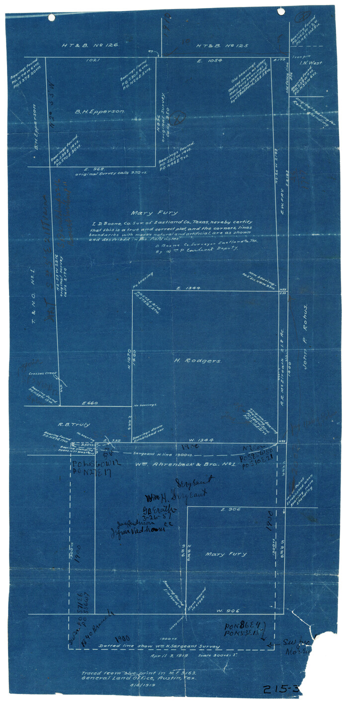
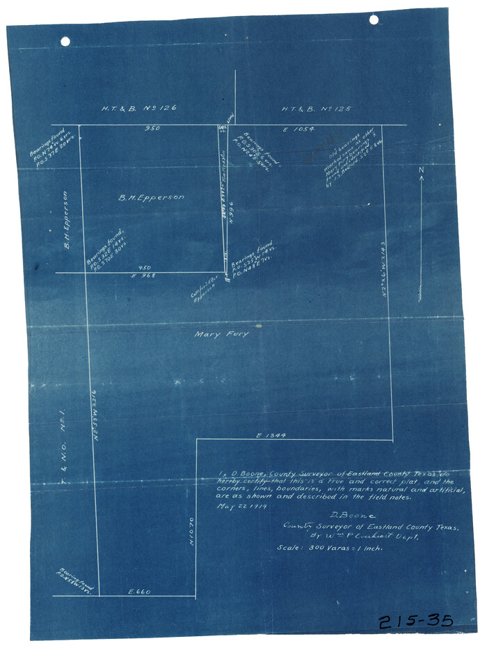
[Sketch showing B. H. Epperson, Mary Fury and H. Rodgers surveys and vicinity]
Print $20.00
- Digital $50.00
[Sketch showing B. H. Epperson, Mary Fury and H. Rodgers surveys and vicinity]
1919
Size: 10.7 x 21.5 inches
93069
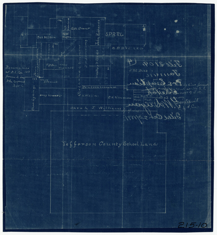
[Sketch of surveys north of Jefferson County School Land]
Print $3.00
- Digital $50.00
[Sketch of surveys north of Jefferson County School Land]
1891
Size: 10.3 x 11.2 inches
91890
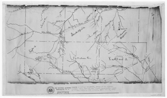
[Sketch of expeditions, trails in Jones, Taylor, Shackelford, Callahan, Buchanan/Stephens and Eastland Counties]
Print $4.00
- Digital $50.00
[Sketch of expeditions, trails in Jones, Taylor, Shackelford, Callahan, Buchanan/Stephens and Eastland Counties]
1873
Size: 10.8 x 18.3 inches
65405
[Sketch of expeditions, trails in Jones, Taylor, Shackelford, Callahan, Buchanan/Stephens and Eastland Counties]
Print $4.00
- Digital $50.00
[Sketch of expeditions, trails in Jones, Taylor, Shackelford, Callahan, Buchanan/Stephens and Eastland Counties]
1873
Size: 10.7 x 18.1 inches
65406
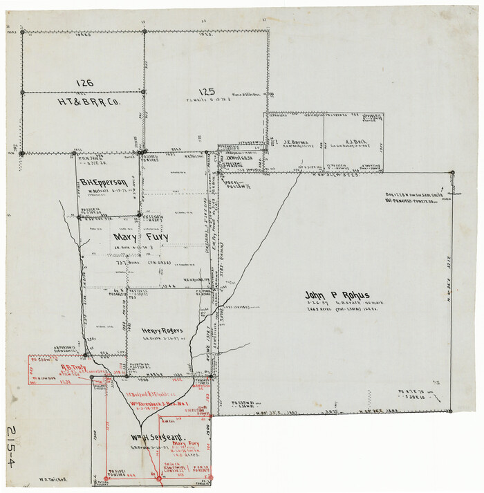
[Sketch of area around Mary Fury and John P. Rohus Surveys]
Print $20.00
- Digital $50.00
[Sketch of area around Mary Fury and John P. Rohus Surveys]
Size: 19.4 x 19.7 inches
91917
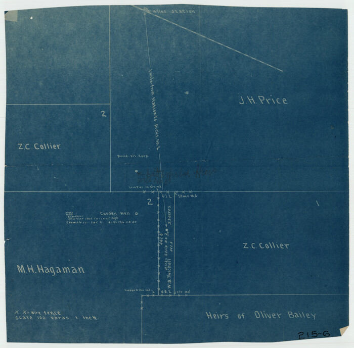
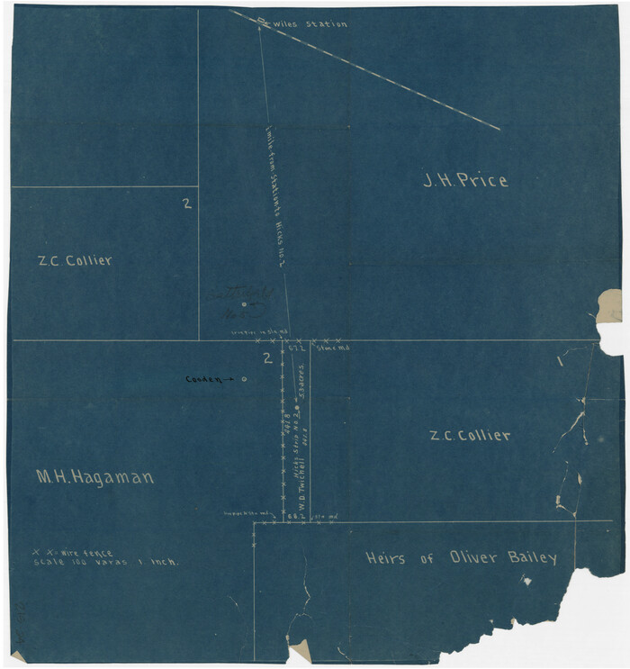
[Sketch of Hicks Strip No. 2 between M. H. Hagaman and Z. C. Collier Surveys]
Print $20.00
- Digital $50.00
[Sketch of Hicks Strip No. 2 between M. H. Hagaman and Z. C. Collier Surveys]
Size: 15.1 x 14.9 inches
91893
[Sketch of Hicks Strip No. 2 between M. H. Hagaman and Z. C. Collier Surveys]
Print $20.00
- Digital $50.00
[Sketch of Hicks Strip No. 2 between M. H. Hagaman and Z. C. Collier Surveys]
Size: 15.3 x 16.3 inches
91914
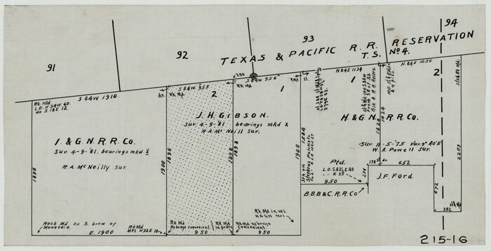
[Sketch in Southeast Part of County around J. H. Gibson Sections 1 and 2]
Print $2.00
- Digital $50.00
[Sketch in Southeast Part of County around J. H. Gibson Sections 1 and 2]
Size: 14.2 x 7.3 inches
91906
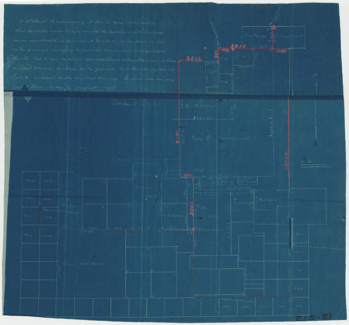
[Sketch around Falls County School Land and surveys to South]
Print $20.00
- Digital $50.00
[Sketch around Falls County School Land and surveys to South]
1894
Size: 13.1 x 12.1 inches
91886
[SE Pt. of Stephens County]
Print $20.00
- Digital $50.00
[SE Pt. of Stephens County]
Size: 38.1 x 35.9 inches
89639
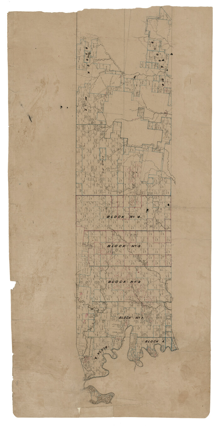
[Peter's Colony surveys in Stephens County]
Print $20.00
- Digital $50.00
[Peter's Colony surveys in Stephens County]
Size: 25.3 x 21.1 inches
75986
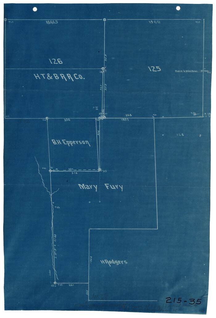
[Mary Fury and B. H. Epperson surveys]
Print $3.00
- Digital $50.00
[Mary Fury and B. H. Epperson surveys]
1919
Size: 10.6 x 14.6 inches
93066
[Mary Fury and B. H. Epperson surveys]
Print $3.00
- Digital $50.00
[Mary Fury and B. H. Epperson surveys]
Size: 10.8 x 15.7 inches
93068
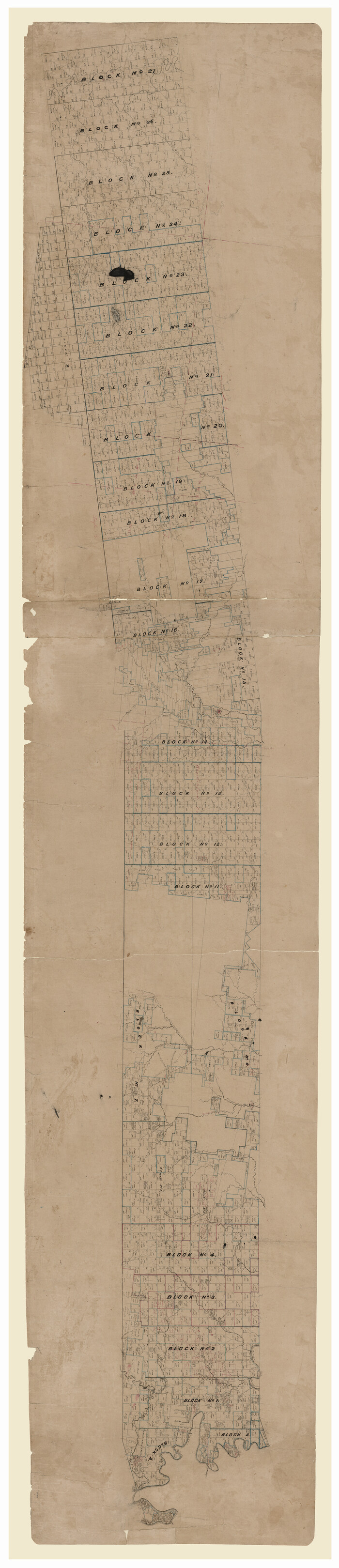
[Map of Texas and Pacific Blocks from Brazos River westward through Palo Pinto, Stephens, Shackelford, Jones, Callahan, Taylor, Fisher, Nolan and Mitchell Counties]
Print $20.00
- Digital $50.00
[Map of Texas and Pacific Blocks from Brazos River westward through Palo Pinto, Stephens, Shackelford, Jones, Callahan, Taylor, Fisher, Nolan and Mitchell Counties]
Size: 35.5 x 19.0 inches
64510
[Map of Texas and Pacific Blocks from Brazos River westward through Palo Pinto, Stephens, Shackelford, Jones, Callahan, Taylor, Fisher, Nolan and Mitchell Counties]
Print $40.00
- Digital $50.00
[Map of Texas and Pacific Blocks from Brazos River westward through Palo Pinto, Stephens, Shackelford, Jones, Callahan, Taylor, Fisher, Nolan and Mitchell Counties]
Size: 87.1 x 18.8 inches
93460
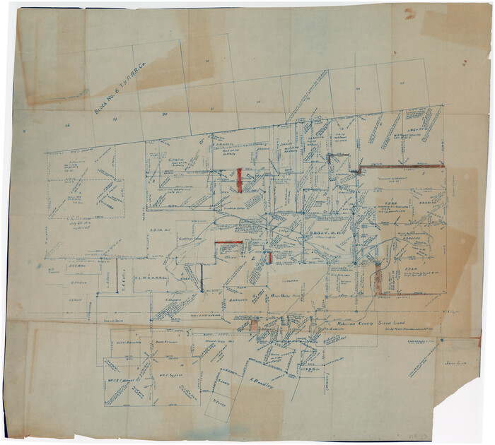
[L. C. Dennison and other surveys to the east, south of the south line of T. & P. Blocks 4 and 6]
Print $20.00
- Digital $50.00
[L. C. Dennison and other surveys to the east, south of the south line of T. & P. Blocks 4 and 6]
1919
Size: 32.1 x 17.6 inches
93050
[Area around John P. Rohus Survey]
Print $20.00
- Digital $50.00
[Area around John P. Rohus Survey]
Size: 19.7 x 19.7 inches
91913
[Area around J. E. Arnold survey]
Print $2.00
- Digital $50.00
[Area around J. E. Arnold survey]
Size: 15.3 x 8.2 inches
91885
Young County Working Sketch 24

Print $20.00
- Digital $50.00
Young County Working Sketch 24
1977
Size: 25.7 x 16.3 inches
62047
[Texas & Pacific RR. Co. Blocks 6 and 4, L. C. Denison, Guadalupe College and vicinity]
Print $20.00
- Digital $50.00
[Texas & Pacific RR. Co. Blocks 6 and 4, L. C. Denison, Guadalupe College and vicinity]
-
Size
32.5 x 19.8 inches
-
Map/Doc
92133
[Surveys made in Peters Colony by Thomas Leckie]
Print $20.00
- Digital $50.00
[Surveys made in Peters Colony by Thomas Leckie]
1859
-
Size
15.1 x 13.4 inches
-
Map/Doc
1984
-
Creation Date
1859
[Surveys in Southeast part of Stephens County]
Print $2.00
- Digital $50.00
[Surveys in Southeast part of Stephens County]
-
Size
9.1 x 7.0 inches
-
Map/Doc
91909
[Surveys Adjacent to W. D. Twichell's near Palo Pinto Creek]
Print $2.00
- Digital $50.00
[Surveys Adjacent to W. D. Twichell's near Palo Pinto Creek]
-
Size
8.4 x 6.6 inches
-
Map/Doc
92101
[Surveys Adjacent to W. D. Twichell's near Palo Pinto Creek]
Print $2.00
- Digital $50.00
[Surveys Adjacent to W. D. Twichell's near Palo Pinto Creek]
-
Size
8.4 x 6.2 inches
-
Map/Doc
92102
[Southern Part of County]
Print $2.00
- Digital $50.00
[Southern Part of County]
-
Size
9.8 x 7.6 inches
-
Map/Doc
91905
[Southeast part of Stephens County]
Print $20.00
- Digital $50.00
[Southeast part of Stephens County]
-
Size
37.2 x 32.7 inches
-
Map/Doc
91844
[Southeast part of County near Jas. H. Price Survey]
Print $20.00
- Digital $50.00
[Southeast part of County near Jas. H. Price Survey]
-
Size
19.3 x 19.3 inches
-
Map/Doc
91888
[Southeast part of County near Jas. H. Price Survey]
Print $20.00
- Digital $50.00
[Southeast part of County near Jas. H. Price Survey]
-
Size
19.9 x 20.0 inches
-
Map/Doc
91915
[Sketch showing position of 287.2 acres of land surveyed for W. D. Twichell]
Print $2.00
- Digital $50.00
[Sketch showing position of 287.2 acres of land surveyed for W. D. Twichell]
1919
-
Size
15.2 x 7.3 inches
-
Map/Doc
91904
-
Creation Date
1919
[Sketch showing B. H. Epperson, Mary Fury and H. Rodgers surveys and vicinity]
Print $20.00
- Digital $50.00
[Sketch showing B. H. Epperson, Mary Fury and H. Rodgers surveys and vicinity]
1919
-
Size
10.7 x 21.5 inches
-
Map/Doc
93069
-
Creation Date
1919
[Sketch of surveys north of Jefferson County School Land]
Print $3.00
- Digital $50.00
[Sketch of surveys north of Jefferson County School Land]
1891
-
Size
10.3 x 11.2 inches
-
Map/Doc
91890
-
Creation Date
1891
[Sketch of expeditions, trails in Jones, Taylor, Shackelford, Callahan, Buchanan/Stephens and Eastland Counties]
Print $4.00
- Digital $50.00
[Sketch of expeditions, trails in Jones, Taylor, Shackelford, Callahan, Buchanan/Stephens and Eastland Counties]
1873
-
Size
10.8 x 18.3 inches
-
Map/Doc
65405
-
Creation Date
1873
[Sketch of expeditions, trails in Jones, Taylor, Shackelford, Callahan, Buchanan/Stephens and Eastland Counties]
Print $4.00
- Digital $50.00
[Sketch of expeditions, trails in Jones, Taylor, Shackelford, Callahan, Buchanan/Stephens and Eastland Counties]
1873
-
Size
10.7 x 18.1 inches
-
Map/Doc
65406
-
Creation Date
1873
[Sketch of area around Mary Fury and John P. Rohus Surveys]
Print $20.00
- Digital $50.00
[Sketch of area around Mary Fury and John P. Rohus Surveys]
-
Size
19.4 x 19.7 inches
-
Map/Doc
91917
[Sketch of Hicks Strip No. 2 between M. H. Hagaman and Z. C. Collier Surveys]
Print $20.00
- Digital $50.00
[Sketch of Hicks Strip No. 2 between M. H. Hagaman and Z. C. Collier Surveys]
-
Size
15.1 x 14.9 inches
-
Map/Doc
91893
[Sketch of Hicks Strip No. 2 between M. H. Hagaman and Z. C. Collier Surveys]
Print $20.00
- Digital $50.00
[Sketch of Hicks Strip No. 2 between M. H. Hagaman and Z. C. Collier Surveys]
-
Size
15.3 x 16.3 inches
-
Map/Doc
91914
[Sketch in Southeast Part of County around J. H. Gibson Sections 1 and 2]
Print $2.00
- Digital $50.00
[Sketch in Southeast Part of County around J. H. Gibson Sections 1 and 2]
-
Size
14.2 x 7.3 inches
-
Map/Doc
91906
[Sketch around Falls County School Land and surveys to South]
Print $20.00
- Digital $50.00
[Sketch around Falls County School Land and surveys to South]
1894
-
Size
13.1 x 12.1 inches
-
Map/Doc
91886
-
Creation Date
1894
[SE Pt. of Stephens County]
Print $20.00
- Digital $50.00
[SE Pt. of Stephens County]
-
Size
38.1 x 35.9 inches
-
Map/Doc
89639
[Peter's Colony surveys in Stephens County]
Print $20.00
- Digital $50.00
[Peter's Colony surveys in Stephens County]
-
Size
25.3 x 21.1 inches
-
Map/Doc
75986
[Mary Fury and B. H. Epperson surveys]
Print $3.00
- Digital $50.00
[Mary Fury and B. H. Epperson surveys]
1919
-
Size
10.6 x 14.6 inches
-
Map/Doc
93066
-
Creation Date
1919
[Mary Fury and B. H. Epperson surveys]
Print $3.00
- Digital $50.00
[Mary Fury and B. H. Epperson surveys]
-
Size
10.8 x 15.7 inches
-
Map/Doc
93068
[Map of Texas and Pacific Blocks from Brazos River westward through Palo Pinto, Stephens, Shackelford, Jones, Callahan, Taylor, Fisher, Nolan and Mitchell Counties]
Print $20.00
- Digital $50.00
[Map of Texas and Pacific Blocks from Brazos River westward through Palo Pinto, Stephens, Shackelford, Jones, Callahan, Taylor, Fisher, Nolan and Mitchell Counties]
-
Size
35.5 x 19.0 inches
-
Map/Doc
64510
[Map of Texas and Pacific Blocks from Brazos River westward through Palo Pinto, Stephens, Shackelford, Jones, Callahan, Taylor, Fisher, Nolan and Mitchell Counties]
Print $40.00
- Digital $50.00
[Map of Texas and Pacific Blocks from Brazos River westward through Palo Pinto, Stephens, Shackelford, Jones, Callahan, Taylor, Fisher, Nolan and Mitchell Counties]
-
Size
87.1 x 18.8 inches
-
Map/Doc
93460
[L. C. Dennison and other surveys to the east, south of the south line of T. & P. Blocks 4 and 6]
Print $20.00
- Digital $50.00
[L. C. Dennison and other surveys to the east, south of the south line of T. & P. Blocks 4 and 6]
1919
-
Size
32.1 x 17.6 inches
-
Map/Doc
93050
-
Creation Date
1919
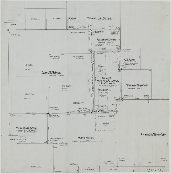
[Guadalupe College]
![91907, [Guadalupe College], Twichell Survey Records](https://historictexasmaps.com/wmedia_w700/maps/91907-1.tif.jpg)
Print $3.00
- Digital $50.00
[Guadalupe College]
-
Size
16.7 x 9.7 inches
-
Map/Doc
91907
[Area around John P. Rohus Survey]
Print $20.00
- Digital $50.00
[Area around John P. Rohus Survey]
-
Size
19.7 x 19.7 inches
-
Map/Doc
91913
[Area around J. E. Arnold survey]
Print $2.00
- Digital $50.00
[Area around J. E. Arnold survey]
-
Size
15.3 x 8.2 inches
-
Map/Doc
91885
Young County Working Sketch 24
Print $20.00
- Digital $50.00
Young County Working Sketch 24
1977
-
Size
25.7 x 16.3 inches
-
Map/Doc
62047
-
Creation Date
1977