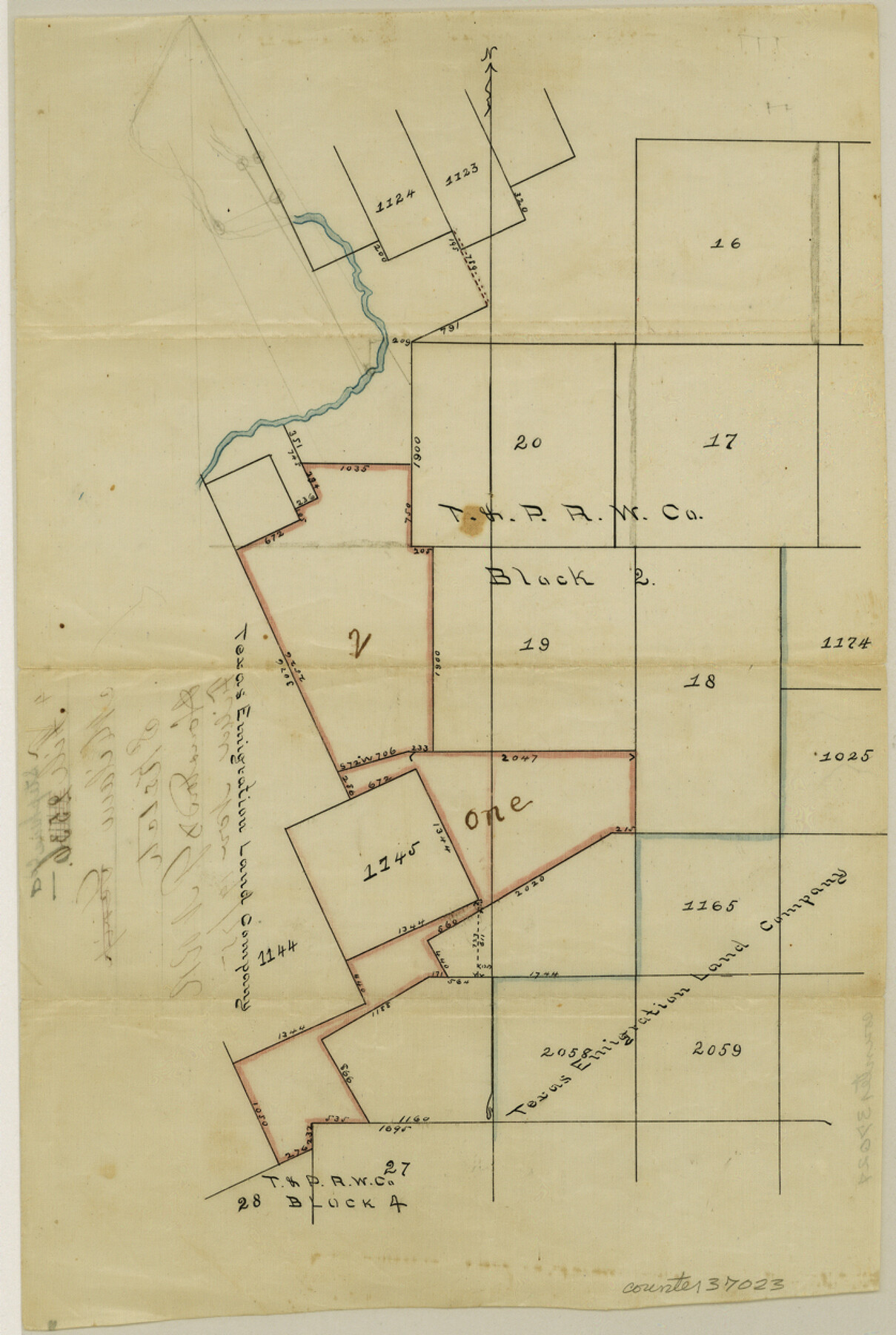
Stephens County Sketch File 6a
[Sketch showing surveys in vicinity of T. E. & L. Survey nos. 1122 - 1125 and S. P. P. R.R. Co. Blk 2, south of the Clear Fork Brazos River]
-
Map/Doc
37023
-
Collection
General Map Collection
-
Object Dates
11/19/1875 (File Date)
-
Counties
Stephens
-
Subjects
Surveying Sketch File
-
Height x Width
12.4 x 8.4 inches
31.5 x 21.3 cm
-
Medium
paper, manuscript
-
Scale
No scale given
-
Features
Clear Fork Brazos River
Part of: General Map Collection
Upton County Rolled Sketch 27

Print $40.00
- Digital $50.00
Upton County Rolled Sketch 27
1945
Size 42.1 x 62.1 inches
Map/Doc 10046
Texas Intracoastal Waterway - Laguna Madre - Dagger Hill to Potrero Grande

Print $20.00
- Digital $50.00
Texas Intracoastal Waterway - Laguna Madre - Dagger Hill to Potrero Grande
1956
Size 38.6 x 27.2 inches
Map/Doc 73509
Crockett County Rolled Sketch 91

Print $40.00
- Digital $50.00
Crockett County Rolled Sketch 91
1928
Size 26.0 x 70.5 inches
Map/Doc 8737
Flight Mission No. DQO-7K, Frame 80, Galveston County

Print $20.00
- Digital $50.00
Flight Mission No. DQO-7K, Frame 80, Galveston County
1952
Size 18.8 x 22.4 inches
Map/Doc 85107
Field Notes of surveys in Hutchinson and Wheeler Counties

Field Notes of surveys in Hutchinson and Wheeler Counties
Map/Doc 81670
Hutchinson County Working Sketch 5

Print $20.00
- Digital $50.00
Hutchinson County Working Sketch 5
1912
Size 16.0 x 11.4 inches
Map/Doc 66363
McClennan County

Print $20.00
- Digital $50.00
McClennan County
1880
Size 23.6 x 25.4 inches
Map/Doc 4596
Randall County

Print $20.00
- Digital $50.00
Randall County
1917
Size 44.7 x 36.9 inches
Map/Doc 16793
Bien & Sterner's New Rail Road Map of the United States and the Canadas compiled from the latest surveys & locations under the direction of Zerah Colburn Esq., editor of the Rail Road Advocate

Print $20.00
- Digital $50.00
Bien & Sterner's New Rail Road Map of the United States and the Canadas compiled from the latest surveys & locations under the direction of Zerah Colburn Esq., editor of the Rail Road Advocate
1855
Size 27.5 x 32.3 inches
Map/Doc 95963
Chambers County NRC Article 33.136 Sketch 12

Print $30.00
- Digital $50.00
Chambers County NRC Article 33.136 Sketch 12
2020
Size 24.0 x 35.9 inches
Map/Doc 96441
Brazos County Working Sketch 9

Print $20.00
- Digital $50.00
Brazos County Working Sketch 9
1982
Size 36.2 x 48.8 inches
Map/Doc 67484
Map of Chicago, Rock Island & Texas Railway

Print $20.00
- Digital $50.00
Map of Chicago, Rock Island & Texas Railway
1892
Size 22.4 x 44.0 inches
Map/Doc 64443
You may also like
Flight Mission No. BQY-15M, Frame 16, Harris County

Print $20.00
- Digital $50.00
Flight Mission No. BQY-15M, Frame 16, Harris County
1953
Size 18.6 x 22.4 inches
Map/Doc 85314
[T. & G. Ry. Main Line, Texas, Right of Way Map, Center to Gary]
![64571, [T. & G. Ry. Main Line, Texas, Right of Way Map, Center to Gary], General Map Collection](https://historictexasmaps.com/wmedia_w700/maps/64571-1.tif.jpg)
Print $40.00
- Digital $50.00
[T. & G. Ry. Main Line, Texas, Right of Way Map, Center to Gary]
1917
Size 31.9 x 121.1 inches
Map/Doc 64571
Garza County Sketch File 15

Print $20.00
- Digital $50.00
Garza County Sketch File 15
1902
Size 16.8 x 14.7 inches
Map/Doc 11545
Starr County Sketch File 39

Print $20.00
- Digital $50.00
Starr County Sketch File 39
1940
Size 22.9 x 22.1 inches
Map/Doc 12339

Flight Mission No. CRC-2R, Frame 134, Chambers County

Print $20.00
- Digital $50.00
Flight Mission No. CRC-2R, Frame 134, Chambers County
1956
Size 18.6 x 22.3 inches
Map/Doc 84750
Flight Mission No. CGI-2N, Frame 185, Cameron County

Print $20.00
- Digital $50.00
Flight Mission No. CGI-2N, Frame 185, Cameron County
1954
Size 18.5 x 22.2 inches
Map/Doc 84545
Shackelford County Sketch File 7

Print $20.00
- Digital $50.00
Shackelford County Sketch File 7
1912
Size 27.2 x 13.5 inches
Map/Doc 12314
Chambers County Rolled Sketch 18

Print $20.00
- Digital $50.00
Chambers County Rolled Sketch 18
1937
Size 42.9 x 29.0 inches
Map/Doc 5426
[Lubbock County Block S and vicinity]
![91321, [Lubbock County Block S and vicinity], Twichell Survey Records](https://historictexasmaps.com/wmedia_w700/maps/91321-1.tif.jpg)
Print $20.00
- Digital $50.00
[Lubbock County Block S and vicinity]
Size 15.1 x 15.8 inches
Map/Doc 91321
San Augustine County Texas

Print $20.00
- Digital $50.00
San Augustine County Texas
1879
Size 23.8 x 16.9 inches
Map/Doc 4623
Chambers County Rolled Sketch 26

Print $20.00
- Digital $50.00
Chambers County Rolled Sketch 26
1947
Size 12.7 x 19.9 inches
Map/Doc 5428