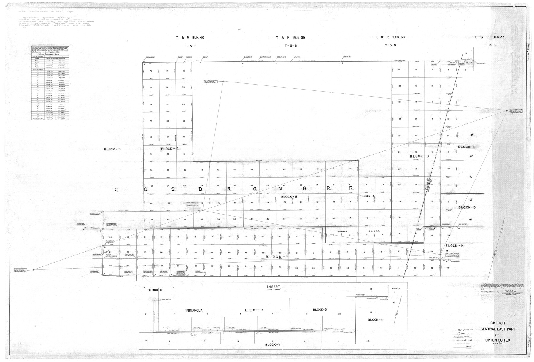
Upton County Rolled Sketch 27
Sketch Central East part of Upton Co. Tex.
-
Map/Doc
10046
-
Collection
General Map Collection
-
Object Dates
1945/3/5 (File Date)
1945/2/1 (Creation Date)
-
People and Organizations
Robt. E. Estes (Surveyor/Engineer)
-
Counties
Upton
-
Subjects
Surveying Rolled Sketch
-
Height x Width
42.1 x 62.1 inches
106.9 x 157.7 cm
-
Scale
1" = 1000 varas
Part of: General Map Collection
[Surveys on Galveston and East Bay]
![248, [Surveys on Galveston and East Bay], General Map Collection](https://historictexasmaps.com/wmedia_w700/maps/248.tif.jpg)
Print $2.00
- Digital $50.00
[Surveys on Galveston and East Bay]
1846
Size 8.8 x 7.9 inches
Map/Doc 248
Presidio County Working Sketch 41

Print $20.00
- Digital $50.00
Presidio County Working Sketch 41
1948
Size 20.3 x 14.4 inches
Map/Doc 71718
Flight Mission No. CRC-5R, Frame 42, Chambers County

Print $20.00
- Digital $50.00
Flight Mission No. CRC-5R, Frame 42, Chambers County
1956
Size 18.6 x 22.3 inches
Map/Doc 84961
Foard County Sketch File 4

Print $5.00
- Digital $50.00
Foard County Sketch File 4
Size 12.4 x 9.5 inches
Map/Doc 22806
Layout of the porciones as described in the Visita General of Laredo, 1767

Layout of the porciones as described in the Visita General of Laredo, 1767
2009
Size 11.0 x 8.5 inches
Map/Doc 94042
Howard County Sketch File 16

Print $40.00
- Digital $50.00
Howard County Sketch File 16
1947
Size 19.7 x 9.0 inches
Map/Doc 26878
Sutton County Sketch File JAC (1)

Print $6.00
- Digital $50.00
Sutton County Sketch File JAC (1)
1937
Size 14.3 x 8.8 inches
Map/Doc 37502
McMullen County Rolled Sketch WSG

Print $20.00
- Digital $50.00
McMullen County Rolled Sketch WSG
Size 25.8 x 33.9 inches
Map/Doc 6738
Culberson County Sketch File EM

Print $7.00
- Digital $50.00
Culberson County Sketch File EM
Size 36.2 x 40.3 inches
Map/Doc 10359
Travis County Appraisal District Plat Map 2_3216

Print $20.00
- Digital $50.00
Travis County Appraisal District Plat Map 2_3216
Size 21.5 x 26.4 inches
Map/Doc 94223
Lubbock County Boundary File 7

Print $40.00
- Digital $50.00
Lubbock County Boundary File 7
Size 20.6 x 5.8 inches
Map/Doc 56523
Morris County Rolled Sketch 2A

Print $20.00
- Digital $50.00
Morris County Rolled Sketch 2A
Size 24.3 x 18.7 inches
Map/Doc 10675
You may also like
Kimble County Rolled Sketch 23

Print $20.00
- Digital $50.00
Kimble County Rolled Sketch 23
Size 16.0 x 21.0 inches
Map/Doc 6513
[Strip between Block 8 and Block K4]
![90599, [Strip between Block 8 and Block K4], Twichell Survey Records](https://historictexasmaps.com/wmedia_w700/maps/90599-1.tif.jpg)
Print $3.00
- Digital $50.00
[Strip between Block 8 and Block K4]
Size 10.0 x 12.4 inches
Map/Doc 90599
Carta de las provincias de Tejas Nuevo Santander, Nuevo Reino de Leon y Nueva Estremadura

Print $20.00
- Digital $50.00
Carta de las provincias de Tejas Nuevo Santander, Nuevo Reino de Leon y Nueva Estremadura
1773
Size 21.5 x 26.6 inches
Map/Doc 3031
Angelina County Sketch File 11f

Print $4.00
- Digital $50.00
Angelina County Sketch File 11f
1885
Size 8.2 x 12.6 inches
Map/Doc 12954
Flight Mission No. CGI-4N, Frame 190, Cameron County

Print $20.00
- Digital $50.00
Flight Mission No. CGI-4N, Frame 190, Cameron County
1955
Size 18.5 x 22.2 inches
Map/Doc 84693
Map of Asylum Lands

Print $20.00
- Digital $50.00
Map of Asylum Lands
1857
Size 28.4 x 18.5 inches
Map/Doc 2459
Roberts County Working Sketch 27

Print $20.00
- Digital $50.00
Roberts County Working Sketch 27
1982
Size 26.6 x 29.4 inches
Map/Doc 63553
Texas Official Travel Map

Digital $50.00
Texas Official Travel Map
Size 33.4 x 36.4 inches
Map/Doc 94424
Pecos County Rolled Sketch 36

Print $20.00
- Digital $50.00
Pecos County Rolled Sketch 36
1906
Size 32.0 x 23.4 inches
Map/Doc 7216
Jones County Sketch File 9

Print $22.00
- Digital $50.00
Jones County Sketch File 9
Size 8.3 x 7.5 inches
Map/Doc 28495
Andrews County Working Sketch 17

Print $20.00
- Digital $50.00
Andrews County Working Sketch 17
1963
Size 30.7 x 27.1 inches
Map/Doc 67063
Bell County Sketch File 23

Print $4.00
- Digital $50.00
Bell County Sketch File 23
1873
Size 8.2 x 12.8 inches
Map/Doc 14414