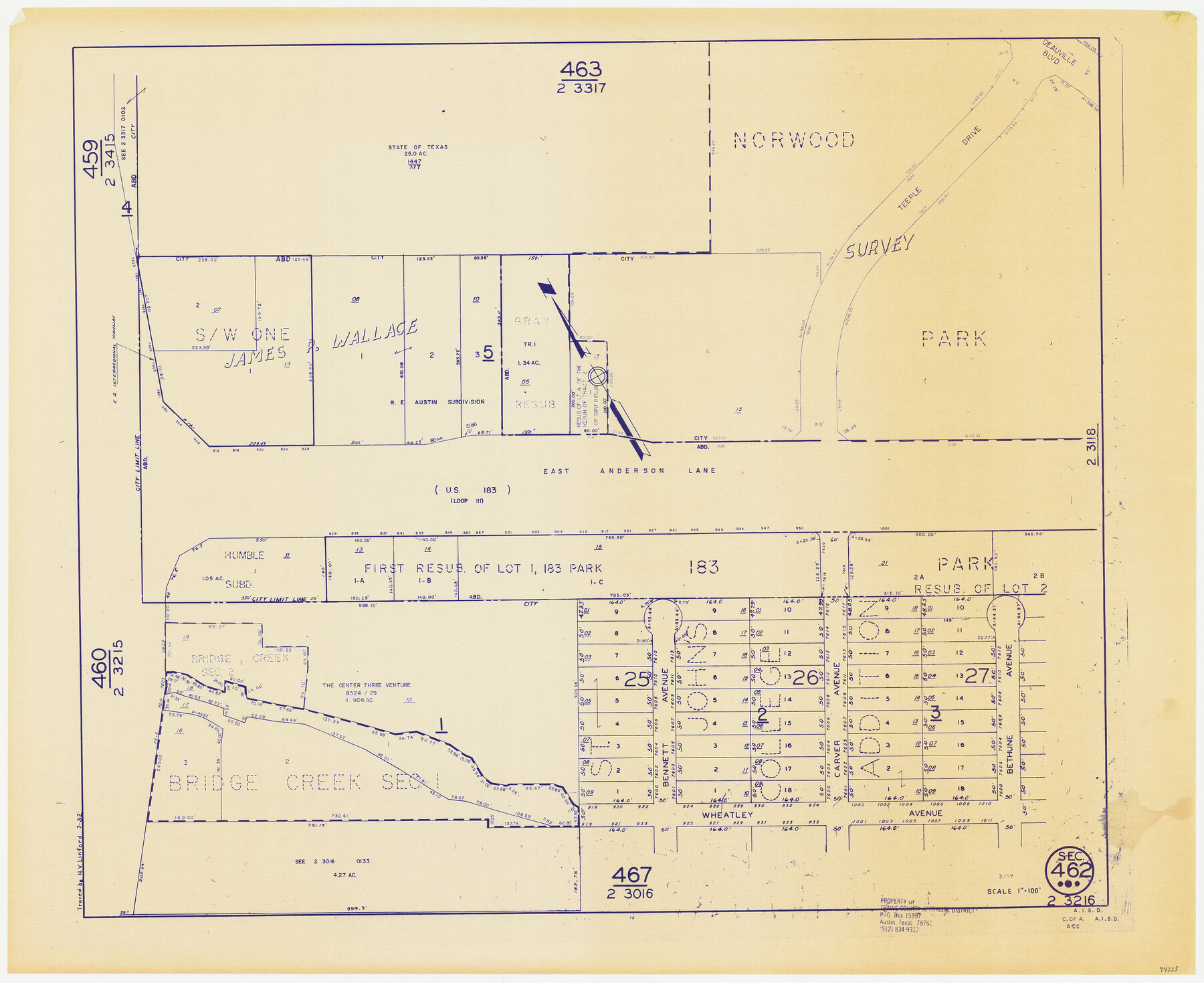
Travis County Appraisal District Plat Map 2_3216
Section 462
-
Map/Doc
94223
-
Collection
General Map Collection
-
Object Dates
1952 (Copy/Tracing Date)
1987 (Edition Date)
-
People and Organizations
Travis County Appraisal District (Publisher)
N.V. Linford (Tracer)
-
Counties
Travis
-
Subjects
City
-
Height x Width
21.5 x 26.4 inches
54.6 x 67.1 cm
-
Medium
blueprint/diazo
-
Scale
1" = 100'
Part of: General Map Collection
Flight Mission No. DCL-6C, Frame 15, Kenedy County

Print $20.00
- Digital $50.00
Flight Mission No. DCL-6C, Frame 15, Kenedy County
1943
Size 18.7 x 22.4 inches
Map/Doc 85872
Archer County

Print $20.00
- Digital $50.00
Archer County
1926
Size 42.9 x 37.8 inches
Map/Doc 73070
Burnet County Sketch File 8

Print $22.00
- Digital $50.00
Burnet County Sketch File 8
Size 8.1 x 6.3 inches
Map/Doc 16689
Map of Collin County

Print $20.00
- Digital $50.00
Map of Collin County
1862
Size 24.4 x 20.5 inches
Map/Doc 1084
Hansford County Sketch File 2

Print $13.00
- Digital $50.00
Hansford County Sketch File 2
1901
Size 76.7 x 25.5 inches
Map/Doc 10476
Dallas County Boundary File 3

Print $6.00
- Digital $50.00
Dallas County Boundary File 3
Size 14.2 x 8.6 inches
Map/Doc 52120
Collingsworth County Working Sketch Graphic Index

Print $20.00
- Digital $50.00
Collingsworth County Working Sketch Graphic Index
1971
Size 41.0 x 34.8 inches
Map/Doc 76499
PSL Field Notes for Blocks 77, B2, B3, and A56 in Winkler County

PSL Field Notes for Blocks 77, B2, B3, and A56 in Winkler County
Map/Doc 81679
Comanche County Sketch File 17

Print $14.00
- Digital $50.00
Comanche County Sketch File 17
Size 8.5 x 8.2 inches
Map/Doc 19086
Tom Green County Sketch File 68

Print $20.00
- Digital $50.00
Tom Green County Sketch File 68
1913
Size 30.8 x 41.5 inches
Map/Doc 10406

[Maps of surveys in Reeves & Culberson Cos]
![61135, [Maps of surveys in Reeves & Culberson Cos], General Map Collection](https://historictexasmaps.com/wmedia_w700/maps/61135.tif.jpg)
Print $20.00
- Digital $50.00
[Maps of surveys in Reeves & Culberson Cos]
1937
Size 30.6 x 24.9 inches
Map/Doc 61135
You may also like
Harris County Sketch File 68

Print $20.00
- Digital $50.00
Harris County Sketch File 68
1939
Size 22.9 x 10.6 inches
Map/Doc 11662
Hamilton County Working Sketch 4

Print $20.00
- Digital $50.00
Hamilton County Working Sketch 4
1935
Size 32.6 x 36.9 inches
Map/Doc 63342
Map of the United States, Canada and a part of Mexico to illustrate Olney's school geography

Print $20.00
- Digital $50.00
Map of the United States, Canada and a part of Mexico to illustrate Olney's school geography
1844
Size 12.1 x 19.0 inches
Map/Doc 93537
[H. & G. N. Block 1]
![90940, [H. & G. N. Block 1], Twichell Survey Records](https://historictexasmaps.com/wmedia_w700/maps/90940-1.tif.jpg)
Print $20.00
- Digital $50.00
[H. & G. N. Block 1]
1873
Size 17.3 x 14.2 inches
Map/Doc 90940
Tyler County Working Sketch Graphic Index

Print $20.00
- Digital $50.00
Tyler County Working Sketch Graphic Index
1944
Size 47.4 x 39.6 inches
Map/Doc 76719
General Highway Map, McMullen County, Texas

Print $20.00
General Highway Map, McMullen County, Texas
1940
Size 24.6 x 18.5 inches
Map/Doc 79193
Reconnoissances of Routes from San Antonio de Bexar, El Paso del Norte &c &c

Print $20.00
- Digital $50.00
Reconnoissances of Routes from San Antonio de Bexar, El Paso del Norte &c &c
1849
Size 26.3 x 38.9 inches
Map/Doc 94853
The Texas Co-Ordinate System, Title 86 Art. 5300A

Print $20.00
- Digital $50.00
The Texas Co-Ordinate System, Title 86 Art. 5300A
1943
Size 27.7 x 30.3 inches
Map/Doc 3122
Crockett County Working Sketch 1

Print $20.00
- Digital $50.00
Crockett County Working Sketch 1
Size 20.7 x 16.7 inches
Map/Doc 68334
Crockett County Sketch File 72

Print $14.00
- Digital $50.00
Crockett County Sketch File 72
Size 14.0 x 8.6 inches
Map/Doc 19862
Harris County Sketch File 30

Print $21.00
- Digital $50.00
Harris County Sketch File 30
Size 11.3 x 8.5 inches
Map/Doc 25416
San Jacinto County Sketch File 23

Print $26.00
San Jacinto County Sketch File 23
1993
Size 14.6 x 8.8 inches
Map/Doc 35803