Chambers County NRC Article 33.136 Sketch 12
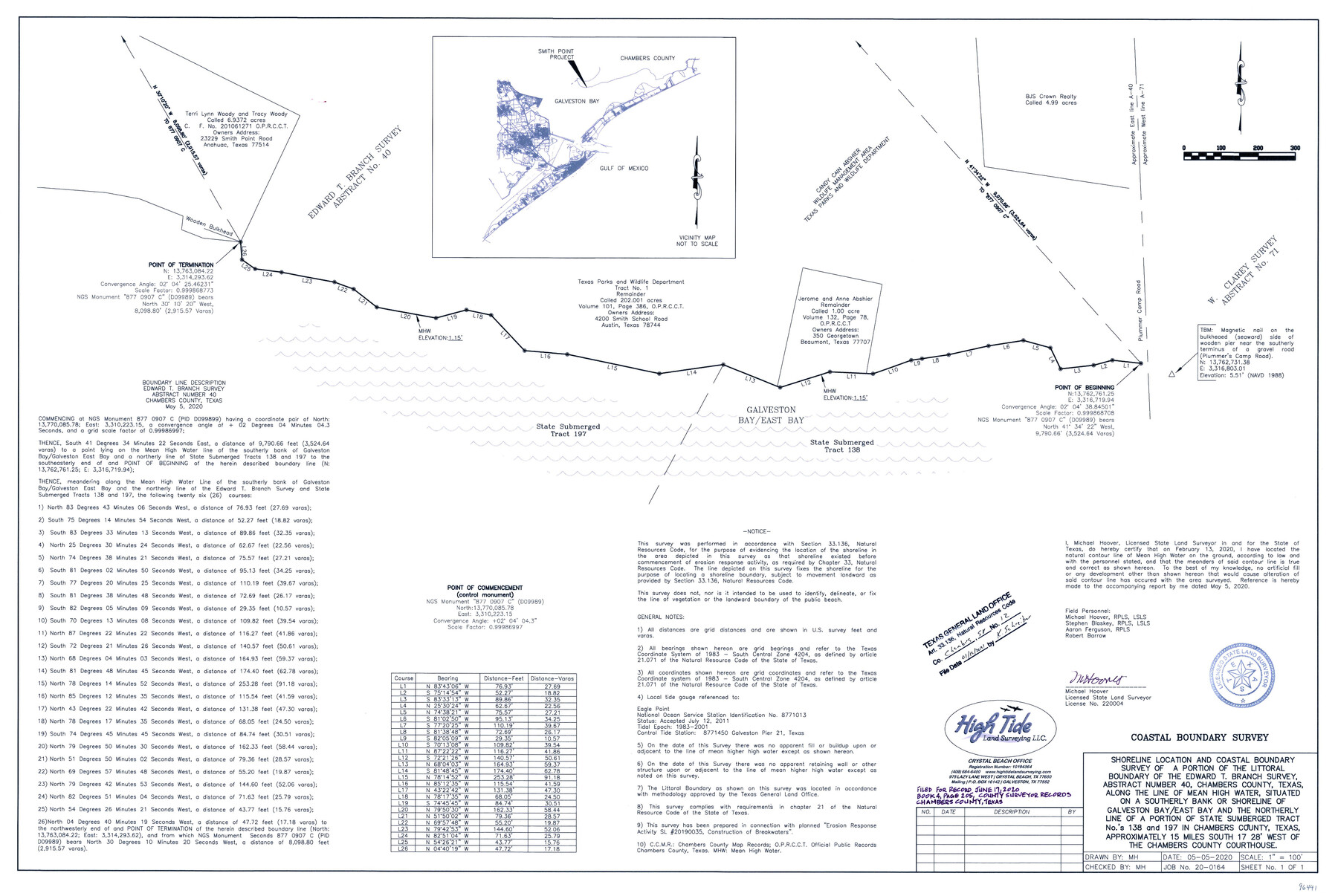
Shoreline location and coastal boundary survey of a portion of the littoral boundary of the Edward T. Branch survey, A-40, along the line of mean high water, situated on a southerly bank or shoreline of Galveston Bay/East Bay
-
Map/Doc
96441
-
Collection
General Map Collection
-
Object Dates
2020/5/5 (Creation Date)
2021/1/12 (File Date)
-
People and Organizations
Michael Hoover (Surveyor/Engineer)
-
Counties
Chambers
-
Subjects
Surveying CBS
-
Height x Width
24.0 x 35.9 inches
61.0 x 91.2 cm
-
Medium
multi-page, multi-format
-
Scale
1" = 100 feet
-
Comments
Project: Smith Point, Edward T. Branch A-40, Chambers County Project No.: GLO # SL20190035
Part of: General Map Collection
Right-of-Way and Track Map, Texas State Railroad operated by the T. and N.O. R.R. Co.

Print $40.00
- Digital $50.00
Right-of-Way and Track Map, Texas State Railroad operated by the T. and N.O. R.R. Co.
1917
Size 25.2 x 56.1 inches
Map/Doc 64171
Calhoun County Rolled Sketch 31

Print $20.00
- Digital $50.00
Calhoun County Rolled Sketch 31
Size 44.5 x 30.0 inches
Map/Doc 5377
[Map of Parker County]
![3948, [Map of Parker County], General Map Collection](https://historictexasmaps.com/wmedia_w700/maps/3948.tif.jpg)
Print $20.00
- Digital $50.00
[Map of Parker County]
1889
Size 25.9 x 32.9 inches
Map/Doc 3948
Texas & Pacific Railway, Longview to Dallas

Print $40.00
- Digital $50.00
Texas & Pacific Railway, Longview to Dallas
1873
Size 14.8 x 100.8 inches
Map/Doc 64099
Floyd County Sketch File 34

Print $4.00
- Digital $50.00
Floyd County Sketch File 34
1892
Size 11.3 x 8.9 inches
Map/Doc 22798
Montgomery Co.

Print $20.00
- Digital $50.00
Montgomery Co.
1840
Size 34.0 x 30.8 inches
Map/Doc 3191
Flight Mission No. DQN-1K, Frame 68, Calhoun County

Print $20.00
- Digital $50.00
Flight Mission No. DQN-1K, Frame 68, Calhoun County
1953
Size 18.6 x 22.2 inches
Map/Doc 84155
Brazoria County Sketch File 22

Print $4.00
- Digital $50.00
Brazoria County Sketch File 22
Size 9.6 x 8.4 inches
Map/Doc 15018
Stonewall County Sketch File 28

Print $14.00
- Digital $50.00
Stonewall County Sketch File 28
1970
Size 14.3 x 8.9 inches
Map/Doc 37300
Flight Mission No. BRA-7M, Frame 74, Jefferson County

Print $20.00
- Digital $50.00
Flight Mission No. BRA-7M, Frame 74, Jefferson County
1953
Size 18.6 x 22.4 inches
Map/Doc 85496
Burleson County Working Sketch 12

Print $20.00
- Digital $50.00
Burleson County Working Sketch 12
1980
Size 20.6 x 12.0 inches
Map/Doc 67731
Bee County Working Sketch 20

Print $20.00
- Digital $50.00
Bee County Working Sketch 20
1982
Size 23.6 x 21.3 inches
Map/Doc 67270
You may also like
General Highway Map, Burleson County, Texas

Print $20.00
General Highway Map, Burleson County, Texas
1940
Size 18.3 x 25.0 inches
Map/Doc 79032
United States - Gulf Coast - Padre I. and Laguna Madre Lat. 27° 12' to Lat. 26° 33' Texas

Print $20.00
- Digital $50.00
United States - Gulf Coast - Padre I. and Laguna Madre Lat. 27° 12' to Lat. 26° 33' Texas
1913
Size 27.1 x 18.3 inches
Map/Doc 72816
[San Patricio No. 2]
![69746, [San Patricio No. 2], General Map Collection](https://historictexasmaps.com/wmedia_w700/maps/69746.tif.jpg)
Print $2.00
- Digital $50.00
[San Patricio No. 2]
1847
Size 8.3 x 11.2 inches
Map/Doc 69746
Victoria County Sketch File A

Print $20.00
- Digital $50.00
Victoria County Sketch File A
1902
Size 23.7 x 22.4 inches
Map/Doc 12597
Hutchinson County Rolled Sketch 37

Print $20.00
- Digital $50.00
Hutchinson County Rolled Sketch 37
1950
Size 24.4 x 44.4 inches
Map/Doc 6296
St. Louis Southwestern Railway of Texas

Print $20.00
- Digital $50.00
St. Louis Southwestern Railway of Texas
1906
Size 21.7 x 30.0 inches
Map/Doc 64452
[Surveys in Austin's Colony along the Yegua River and Cedar Creek]
![67, [Surveys in Austin's Colony along the Yegua River and Cedar Creek], General Map Collection](https://historictexasmaps.com/wmedia_w700/maps/67.tif.jpg)
Print $20.00
- Digital $50.00
[Surveys in Austin's Colony along the Yegua River and Cedar Creek]
1835
Size 15.7 x 19.3 inches
Map/Doc 67
Uvalde County Working Sketch 15

Print $20.00
- Digital $50.00
Uvalde County Working Sketch 15
1945
Size 18.5 x 26.9 inches
Map/Doc 72085
Roberts County Working Sketch 10

Print $20.00
- Digital $50.00
Roberts County Working Sketch 10
1965
Size 23.0 x 29.0 inches
Map/Doc 63536
Refugio County Sketch File 26

Print $4.00
- Digital $50.00
Refugio County Sketch File 26
Size 12.9 x 8.4 inches
Map/Doc 35292
Jasper County Sketch File 19

Print $6.00
- Digital $50.00
Jasper County Sketch File 19
1890
Size 14.2 x 8.8 inches
Map/Doc 27815
Sterling County Rolled Sketch X

Print $117.00
- Digital $50.00
Sterling County Rolled Sketch X
Size 15.3 x 9.6 inches
Map/Doc 49097