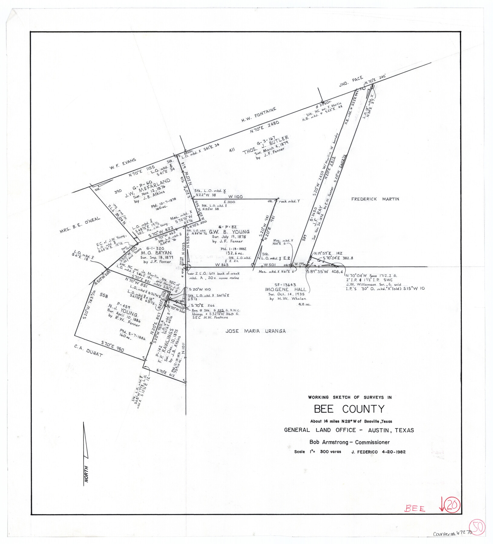
Bee County Working Sketch 20
-
Map/Doc
67270
-
Collection
General Map Collection
-
Object Dates
4/20/1982 (Creation Date)
-
People and Organizations
Jeff Federico (Draftsman)
Bob Armstrong (GLO Commissioner)
-
Counties
Bee
-
Subjects
Surveying Working Sketch
-
Height x Width
23.6 x 21.3 inches
59.9 x 54.1 cm
-
Scale
1" = 300 varas
-
Comments
Surveys located about 14 miles North 28 degrees West of Beeville, Texas.
Part of: General Map Collection
Flight Mission No. CUG-2P, Frame 29, Kleberg County

Print $20.00
- Digital $50.00
Flight Mission No. CUG-2P, Frame 29, Kleberg County
1956
Size 18.6 x 22.4 inches
Map/Doc 86194
Wilson County Boundary File 1

Print $58.00
- Digital $50.00
Wilson County Boundary File 1
Size 9.6 x 4.5 inches
Map/Doc 60058
Mitchell County Boundary File 2

Print $4.00
- Digital $50.00
Mitchell County Boundary File 2
Size 8.9 x 7.3 inches
Map/Doc 57367
Angelina County Working Sketch 1

Print $20.00
- Digital $50.00
Angelina County Working Sketch 1
Size 17.3 x 17.8 inches
Map/Doc 67081
Cass County Working Sketch 46

Print $20.00
- Digital $50.00
Cass County Working Sketch 46
1989
Size 26.8 x 30.6 inches
Map/Doc 67949
Atascosa County

Print $20.00
- Digital $50.00
Atascosa County
1873
Size 22.2 x 23.1 inches
Map/Doc 3249
Comal County Working Sketch 7

Print $20.00
- Digital $50.00
Comal County Working Sketch 7
1950
Size 42.1 x 31.8 inches
Map/Doc 68173
Liberty County Sketch File 35

Print $40.00
- Digital $50.00
Liberty County Sketch File 35
1890
Size 17.5 x 15.5 inches
Map/Doc 29971
Flight Mission No. BRA-3M, Frame 194, Jefferson County

Print $20.00
- Digital $50.00
Flight Mission No. BRA-3M, Frame 194, Jefferson County
1953
Size 18.8 x 22.4 inches
Map/Doc 85409
San Jacinto County Working Sketch 43

Print $20.00
- Digital $50.00
San Jacinto County Working Sketch 43
1981
Size 36.4 x 45.5 inches
Map/Doc 63757
Upton County Working Sketch 56

Print $20.00
- Digital $50.00
Upton County Working Sketch 56
1985
Size 43.9 x 43.8 inches
Map/Doc 69553
Glasscock County Rolled Sketch 8

Print $20.00
- Digital $50.00
Glasscock County Rolled Sketch 8
1951
Size 37.3 x 31.1 inches
Map/Doc 9057
You may also like
San Augustine County Working Sketch 11a

Print $20.00
- Digital $50.00
San Augustine County Working Sketch 11a
Size 18.8 x 24.4 inches
Map/Doc 63698
Flight Mission No. DQN-1K, Frame 123, Calhoun County

Print $20.00
- Digital $50.00
Flight Mission No. DQN-1K, Frame 123, Calhoun County
1953
Size 18.4 x 22.2 inches
Map/Doc 84189
Stephens County Sketch File 10c

Print $6.00
- Digital $50.00
Stephens County Sketch File 10c
Size 7.8 x 11.5 inches
Map/Doc 37052
Wharton County

Print $40.00
- Digital $50.00
Wharton County
1894
Size 52.3 x 56.3 inches
Map/Doc 16923
Cooke County Working Sketch 14

Print $40.00
- Digital $50.00
Cooke County Working Sketch 14
1944
Size 34.1 x 49.7 inches
Map/Doc 68251
Robertson County Rolled Sketch 1

Print $20.00
- Digital $50.00
Robertson County Rolled Sketch 1
1966
Size 45.5 x 28.9 inches
Map/Doc 9862
Current Miscellaneous File 19

Print $10.00
- Digital $50.00
Current Miscellaneous File 19
Size 11.8 x 8.8 inches
Map/Doc 73849
Galveston County NRC Article 33.136 Sketch 6

Print $20.00
- Digital $50.00
Galveston County NRC Article 33.136 Sketch 6
2001
Size 23.1 x 33.9 inches
Map/Doc 61588
Matagorda Light to Aransas Pass

Print $20.00
- Digital $50.00
Matagorda Light to Aransas Pass
1965
Size 34.3 x 45.0 inches
Map/Doc 73398
Flight Mission No. DCL-5C, Frame 25, Kenedy County

Print $20.00
- Digital $50.00
Flight Mission No. DCL-5C, Frame 25, Kenedy County
1943
Size 18.4 x 22.3 inches
Map/Doc 85837
El Paso County Working Sketch 45

Print $20.00
- Digital $50.00
El Paso County Working Sketch 45
1986
Size 38.0 x 27.0 inches
Map/Doc 69067
Henderson County Rolled Sketch 11

Print $20.00
- Digital $50.00
Henderson County Rolled Sketch 11
1915
Size 29.4 x 42.2 inches
Map/Doc 75949