Glasscock County Rolled Sketch 8
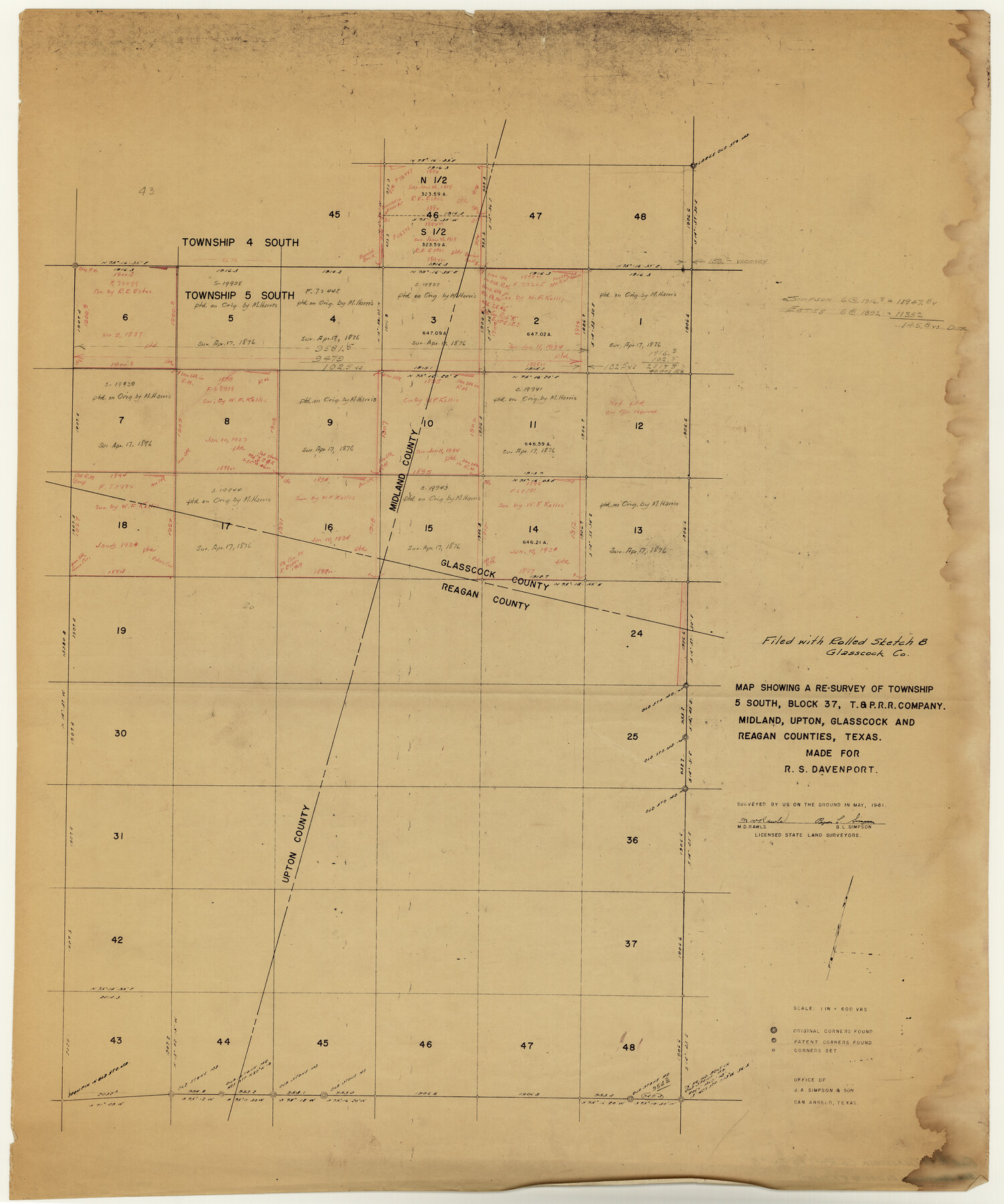
Map showing a re-survey of Township 5 South, Block 37, T. & P. R.R. Company, Midland, Upton, Glasscock, and Reagan Counties, Texas made for R.S. Davenport
-
Map/Doc
9057
-
Collection
General Map Collection
-
Object Dates
5/1951 (Creation Date)
-
People and Organizations
M.D. Rawls (Surveyor/Engineer)
Byron L. Simpson (Surveyor/Engineer)
-
Counties
Glasscock Midland Upton Reagan
-
Subjects
Surveying Rolled Sketch
-
Height x Width
37.3 x 31.1 inches
94.7 x 79.0 cm
-
Scale
1" = 600 varas
-
Comments
Sheet 2 of 2. See 9056 for sheet 1.
Related maps
Glasscock County Rolled Sketch 8

Print $20.00
- Digital $50.00
Glasscock County Rolled Sketch 8
1951
Size 38.4 x 32.3 inches
Map/Doc 9056
Part of: General Map Collection
Moore County Working Sketch 16

Print $20.00
- Digital $50.00
Moore County Working Sketch 16
1981
Size 26.3 x 23.2 inches
Map/Doc 71198
Maverick County Sketch File 2

Print $40.00
- Digital $50.00
Maverick County Sketch File 2
1875
Size 18.2 x 14.0 inches
Map/Doc 31031
Erath County Sketch File 35

Print $8.00
- Digital $50.00
Erath County Sketch File 35
1992
Size 14.5 x 8.8 inches
Map/Doc 22326
Culberson County Working Sketch 47

Print $20.00
- Digital $50.00
Culberson County Working Sketch 47
1971
Size 25.7 x 36.5 inches
Map/Doc 68501
Nueces County NRC Article 33.136 Location Key Sheet

Print $20.00
- Digital $50.00
Nueces County NRC Article 33.136 Location Key Sheet
1975
Size 27.3 x 23.0 inches
Map/Doc 88587
University Land Field Notes for Blocks 19 and 20 in Pecos County

University Land Field Notes for Blocks 19 and 20 in Pecos County
Map/Doc 81724
Map of Newton Co.

Print $20.00
- Digital $50.00
Map of Newton Co.
1918
Size 46.4 x 39.4 inches
Map/Doc 81987

Angelina County Working Sketch 51

Print $20.00
- Digital $50.00
Angelina County Working Sketch 51
1988
Size 44.0 x 23.0 inches
Map/Doc 67135
Gulf Oil Corp. Fishgide - Port Isabel

Gulf Oil Corp. Fishgide - Port Isabel
1960
Size 12.1 x 22.4 inches
Map/Doc 75981
Chambers County Working Sketch 25

Print $20.00
- Digital $50.00
Chambers County Working Sketch 25
1980
Size 16.6 x 28.5 inches
Map/Doc 68008
Dimmit County Working Sketch 23

Print $20.00
- Digital $50.00
Dimmit County Working Sketch 23
1954
Size 22.5 x 23.3 inches
Map/Doc 68684
You may also like
East Line of Lipscomb County

Print $20.00
- Digital $50.00
East Line of Lipscomb County
Size 8.9 x 21.8 inches
Map/Doc 91318
Map of Brazoria County, Texas

Print $20.00
- Digital $50.00
Map of Brazoria County, Texas
1879
Size 28.0 x 26.5 inches
Map/Doc 589
Chart of the West Indies and Spanish Dominions in North America

Print $20.00
- Digital $50.00
Chart of the West Indies and Spanish Dominions in North America
1803
Size 25.7 x 39.4 inches
Map/Doc 97137

Aransas County Sketch File 11

Print $40.00
- Digital $50.00
Aransas County Sketch File 11
Size 40.6 x 31.4 inches
Map/Doc 10318
Flight Mission No. DAH-17M, Frame 20, Orange County

Print $20.00
- Digital $50.00
Flight Mission No. DAH-17M, Frame 20, Orange County
1953
Size 18.6 x 22.6 inches
Map/Doc 86883
General Highway Map, Harris County, Texas

Print $20.00
General Highway Map, Harris County, Texas
1939
Size 24.7 x 18.4 inches
Map/Doc 79115
[Hockley, Lubbock, Terry and Lynn Corner]
![92954, [Hockley, Lubbock, Terry and Lynn Corner], Twichell Survey Records](https://historictexasmaps.com/wmedia_w700/maps/92954-1.tif.jpg)
Print $20.00
- Digital $50.00
[Hockley, Lubbock, Terry and Lynn Corner]
Size 24.5 x 18.9 inches
Map/Doc 92954
Brewster County Working Sketch 4

Print $20.00
- Digital $50.00
Brewster County Working Sketch 4
1908
Size 15.7 x 20.5 inches
Map/Doc 67537
Llano County Sketch File 15

Print $2.00
- Digital $50.00
Llano County Sketch File 15
Size 10.4 x 7.7 inches
Map/Doc 30391
Houston County Working Sketch 13

Print $20.00
- Digital $50.00
Houston County Working Sketch 13
1956
Size 39.3 x 39.6 inches
Map/Doc 66243
Post Route Map of the State of Texas, Showing Post Offices with the Intermediate Distances on Mail Routes

Print $40.00
- Digital $50.00
Post Route Map of the State of Texas, Showing Post Offices with the Intermediate Distances on Mail Routes
1908
Size 52.5 x 35.1 inches
Map/Doc 3163