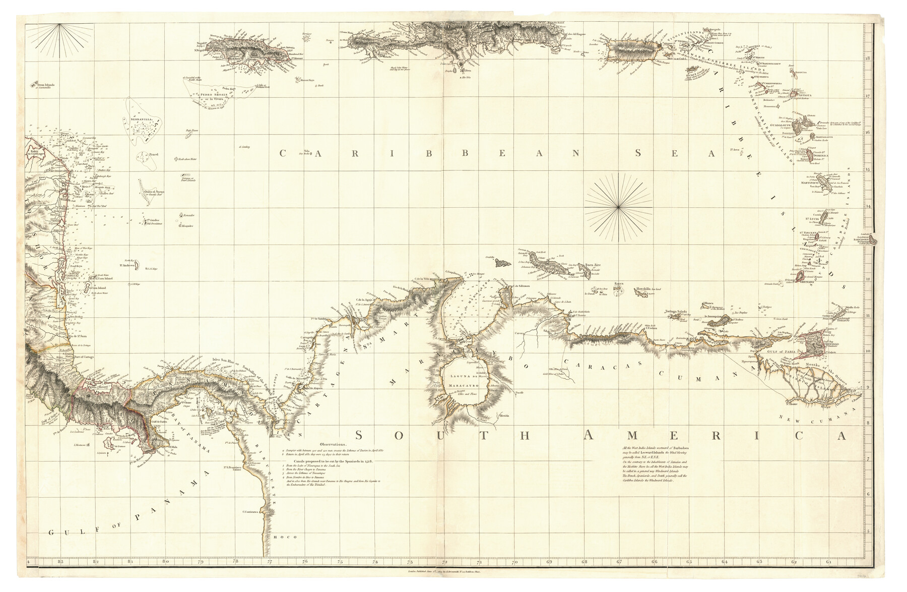
Chart of the West Indies and Spanish Dominions in North America
-
Map/Doc
97137
-
Collection
General Map Collection
-
Object Dates
6/1/1803 (Creation Date)
-
People and Organizations
A. Arrowsmith (Publisher)
-
Height x Width
25.7 x 39.4 inches
65.3 x 100.1 cm
-
Comments
SE quadrant of a map in four pieces. See 97136, 97138, and 97139 for other pieces. See 97153 for digital composite of all four pieces.
Related maps
Chart of the West Indies and Spanish Dominions in North America

Print $20.00
- Digital $50.00
Chart of the West Indies and Spanish Dominions in North America
1803
Size 25.3 x 38.4 inches
Map/Doc 97136
Chart of the West Indies and Spanish Dominions in North America

Print $20.00
- Digital $50.00
Chart of the West Indies and Spanish Dominions in North America
1803
Size 25.6 x 39.2 inches
Map/Doc 97138
Chart of the West Indies and Spanish Dominions in North America

Print $20.00
- Digital $50.00
Chart of the West Indies and Spanish Dominions in North America
1803
Size 25.5 x 38.9 inches
Map/Doc 97139
Chart of the West Indies and Spanish Dominions in North America

Print $40.00
- Digital $50.00
Chart of the West Indies and Spanish Dominions in North America
Size 49.1 x 75.6 inches
Map/Doc 97153
Part of: General Map Collection

Map of Nacogdoches County

Print $40.00
- Digital $50.00
Map of Nacogdoches County
1839
Size 81.0 x 40.9 inches
Map/Doc 93374
La Salle County Sketch File 15

Print $4.00
- Digital $50.00
La Salle County Sketch File 15
1883
Size 8.6 x 8.4 inches
Map/Doc 29485
Palo Pinto County Working Sketch 8

Print $20.00
- Digital $50.00
Palo Pinto County Working Sketch 8
1922
Map/Doc 71391
Jasper County Working Sketch 31

Print $20.00
- Digital $50.00
Jasper County Working Sketch 31
1963
Size 38.2 x 37.7 inches
Map/Doc 66493
Webb County Working Sketch 42

Print $20.00
- Digital $50.00
Webb County Working Sketch 42
1941
Size 12.2 x 16.1 inches
Map/Doc 72407
Pressler's Map of the State of Texas

Print $40.00
- Digital $50.00
Pressler's Map of the State of Texas
1858
Size 47.6 x 51.9 inches
Map/Doc 709
Zapata County Sketch File 1

Print $20.00
- Digital $50.00
Zapata County Sketch File 1
1875
Size 30.5 x 21.4 inches
Map/Doc 12717
Intracoastal Waterway in Texas - Corpus Christi to Point Isabel including Arroyo Colorado to Mo. Pac. R.R. Bridge Near Harlingen

Print $20.00
- Digital $50.00
Intracoastal Waterway in Texas - Corpus Christi to Point Isabel including Arroyo Colorado to Mo. Pac. R.R. Bridge Near Harlingen
1933
Size 28.0 x 40.8 inches
Map/Doc 61849
Colorado County Working Sketch 19

Print $20.00
- Digital $50.00
Colorado County Working Sketch 19
1958
Size 25.3 x 19.1 inches
Map/Doc 68119
Comanche County Sketch File 4

Print $40.00
- Digital $50.00
Comanche County Sketch File 4
1855
Size 19.0 x 15.9 inches
Map/Doc 19057
United States, 1956 Revised Edition

Print $40.00
- Digital $50.00
United States, 1956 Revised Edition
1946
Size 48.0 x 36.3 inches
Map/Doc 78631
You may also like
Liberty County Rolled Sketch 15

Print $20.00
- Digital $50.00
Liberty County Rolled Sketch 15
2015
Size 36.1 x 24.3 inches
Map/Doc 94022
Kerr County Working Sketch 2

Print $20.00
- Digital $50.00
Kerr County Working Sketch 2
1926
Size 18.6 x 17.9 inches
Map/Doc 70033
Floyd County Working Sketch 6

Print $20.00
- Digital $50.00
Floyd County Working Sketch 6
1965
Size 22.9 x 31.3 inches
Map/Doc 69185
Val Verde County Working Sketch 112

Print $40.00
- Digital $50.00
Val Verde County Working Sketch 112
1990
Size 48.2 x 30.8 inches
Map/Doc 72247
From Citizens of Nacogdoches County Living Near the Sabine River for the Creation of a New Judicial County (Unnamed), Undated

Print $20.00
From Citizens of Nacogdoches County Living Near the Sabine River for the Creation of a New Judicial County (Unnamed), Undated
2020
Size 19.9 x 21.7 inches
Map/Doc 96411
Fisher County Rolled Sketch 6

Print $20.00
- Digital $50.00
Fisher County Rolled Sketch 6
1971
Size 26.9 x 26.7 inches
Map/Doc 5877
Karnes County Sketch File 17

Print $4.00
- Digital $50.00
Karnes County Sketch File 17
1873
Size 12.8 x 8.0 inches
Map/Doc 28622
Plan of the C. C. S. D. & R. G. N. G. R.R.

Print $20.00
- Digital $50.00
Plan of the C. C. S. D. & R. G. N. G. R.R.
1878
Size 14.3 x 40.9 inches
Map/Doc 64481
Perspective Map of Texarkana, Texas and Arkansas

Print $20.00
Perspective Map of Texarkana, Texas and Arkansas
1888
Size 18.1 x 29.2 inches
Map/Doc 93485
Mitchell County Rolled Sketch 2B

Print $20.00
- Digital $50.00
Mitchell County Rolled Sketch 2B
Size 26.9 x 18.6 inches
Map/Doc 6784
Map of Brett Ranch situated in McMullen & La Salle Counties

Print $20.00
- Digital $50.00
Map of Brett Ranch situated in McMullen & La Salle Counties
Size 20.0 x 22.3 inches
Map/Doc 5068
