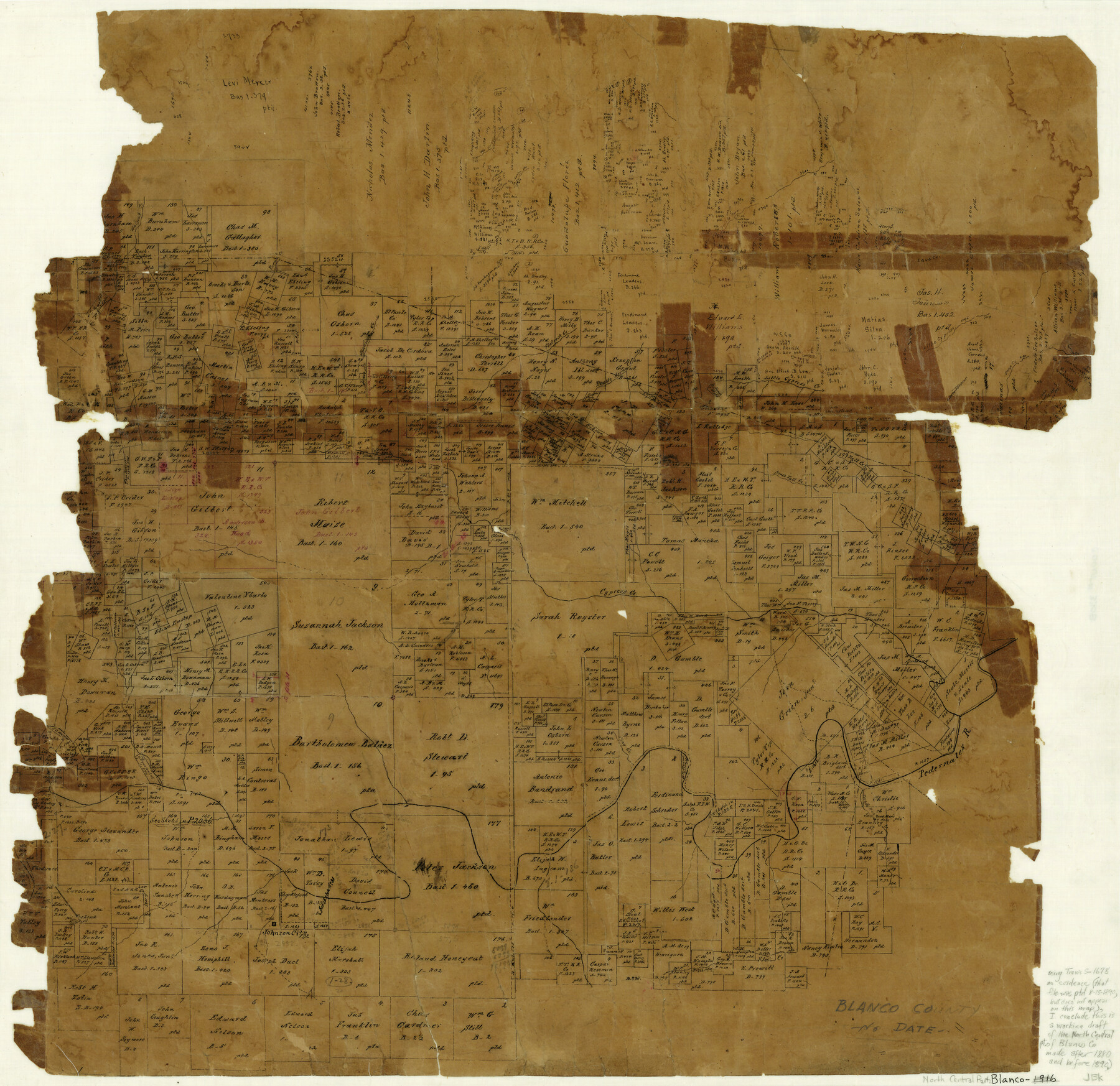
Blanco County
-
Map/Doc
3308
-
Collection
General Map Collection
-
Counties
Blanco
-
Subjects
County
-
Height x Width
23.4 x 23.9 inches
59.4 x 60.7 cm
-
Comments
Note on map: "Using the file "Travis-S-1678" as evidence (that file was patented August 15, 1890, but does not appear on this map), I conclude this is a working draft of the North Central part of Blanco Co. made after 1880 and before 1890. JBK"
-
Features
Spring Creek
Flat Creek
Toehead Mountain
Johnson City
Dead Man's Creek
Flag Creek
Fall Creek
Pecan Creek
Tiger Creek
Walnut Creek
Pedernales River
Cypress Creek
South Fall Creek
Deep Creek
Double Horn Creek
Slickrock [sic] Creek
Flatrock [sic] Creek
Little Cypress [Creek]
Part of: General Map Collection
Zavala County Working Sketch 22

Print $40.00
- Digital $50.00
Zavala County Working Sketch 22
1980
Size 70.4 x 43.5 inches
Map/Doc 62097
Travis County State Real Property Sketch 15

Print $20.00
- Digital $50.00
Travis County State Real Property Sketch 15
1995
Size 29.6 x 29.5 inches
Map/Doc 61674
La Salle County Rolled Sketch 22

Print $20.00
- Digital $50.00
La Salle County Rolled Sketch 22
1955
Size 31.0 x 30.3 inches
Map/Doc 6585
Flight Mission No. DQN-5K, Frame 58, Calhoun County

Print $20.00
- Digital $50.00
Flight Mission No. DQN-5K, Frame 58, Calhoun County
1953
Size 15.5 x 15.3 inches
Map/Doc 84401
Denton County Texas

Print $20.00
- Digital $50.00
Denton County Texas
1896
Size 18.4 x 31.6 inches
Map/Doc 4530
Coke County Sketch File 27

Print $26.00
- Digital $50.00
Coke County Sketch File 27
1937
Size 11.2 x 8.7 inches
Map/Doc 18638
Mexico, Regia et Celebris Hispaniae Novae Civitas [and] Cusco, Rengi Peru in Novo Orbe Casvt
![97025, Mexico, Regia et Celebris Hispaniae Novae Civitas [and] Cusco, Rengi Peru in Novo Orbe Casvt, General Map Collection](https://historictexasmaps.com/wmedia_w700/maps/97025-1.tif.jpg)
Print $20.00
- Digital $50.00
Mexico, Regia et Celebris Hispaniae Novae Civitas [and] Cusco, Rengi Peru in Novo Orbe Casvt
1572
Size 13.8 x 20.1 inches
Map/Doc 97025
Dickens County Sketch File 33

Print $10.00
- Digital $50.00
Dickens County Sketch File 33
1947
Size 14.5 x 9.1 inches
Map/Doc 21025
Collingsworth County

Print $20.00
- Digital $50.00
Collingsworth County
1880
Size 24.9 x 20.0 inches
Map/Doc 3420
Shelby County Sketch File 22

Print $6.00
- Digital $50.00
Shelby County Sketch File 22
Size 15.4 x 10.2 inches
Map/Doc 36643
Comal County Working Sketch 4

Print $20.00
- Digital $50.00
Comal County Working Sketch 4
1950
Size 38.3 x 24.3 inches
Map/Doc 68170
United States Bathymetric and Fishing Maps including Topographic/Bathymetric Maps

Print $40.00
- Digital $50.00
United States Bathymetric and Fishing Maps including Topographic/Bathymetric Maps
1989
Size 21.8 x 54.8 inches
Map/Doc 73556
You may also like
Blanco County Working Sketch 43

Print $20.00
- Digital $50.00
Blanco County Working Sketch 43
1993
Size 42.7 x 26.5 inches
Map/Doc 67403
County Map of the State of Texas Showing also portions of the Adjoining States and Territories (Inset: Plan of Galveston and Vicinity)

Print $20.00
- Digital $50.00
County Map of the State of Texas Showing also portions of the Adjoining States and Territories (Inset: Plan of Galveston and Vicinity)
1873
Size 15.5 x 23.1 inches
Map/Doc 93696
Orange County Rolled Sketch 26

Print $20.00
- Digital $50.00
Orange County Rolled Sketch 26
1952
Size 35.2 x 43.0 inches
Map/Doc 9649
Menard County Rolled Sketch 2

Print $20.00
- Digital $50.00
Menard County Rolled Sketch 2
1883
Size 25.0 x 19.9 inches
Map/Doc 6752
Motley County Working Sketch 6

Print $20.00
- Digital $50.00
Motley County Working Sketch 6
1963
Size 17.6 x 29.3 inches
Map/Doc 71211
Presidio County Working Sketch 25

Print $20.00
- Digital $50.00
Presidio County Working Sketch 25
1945
Size 22.8 x 18.9 inches
Map/Doc 71701
Gregg County Rolled Sketch 17

Print $20.00
- Digital $50.00
Gregg County Rolled Sketch 17
1933
Size 14.2 x 27.5 inches
Map/Doc 6041
Cottle County Rolled Sketch E

Print $20.00
- Digital $50.00
Cottle County Rolled Sketch E
1917
Size 29.9 x 28.7 inches
Map/Doc 8674
Howard County Rolled Sketch 8

Print $20.00
- Digital $50.00
Howard County Rolled Sketch 8
Size 16.8 x 40.2 inches
Map/Doc 6237
Refugio County NRC Article 33.136 Sketch 2

Print $26.00
- Digital $50.00
Refugio County NRC Article 33.136 Sketch 2
2003
Size 24.5 x 36.5 inches
Map/Doc 78536
Brewster County Working Sketch 118

Print $20.00
- Digital $50.00
Brewster County Working Sketch 118
1929
Size 27.0 x 20.5 inches
Map/Doc 67718
Flight Mission No. DCL-7C, Frame 2, Kenedy County

Print $20.00
- Digital $50.00
Flight Mission No. DCL-7C, Frame 2, Kenedy County
1943
Size 18.5 x 22.6 inches
Map/Doc 85994