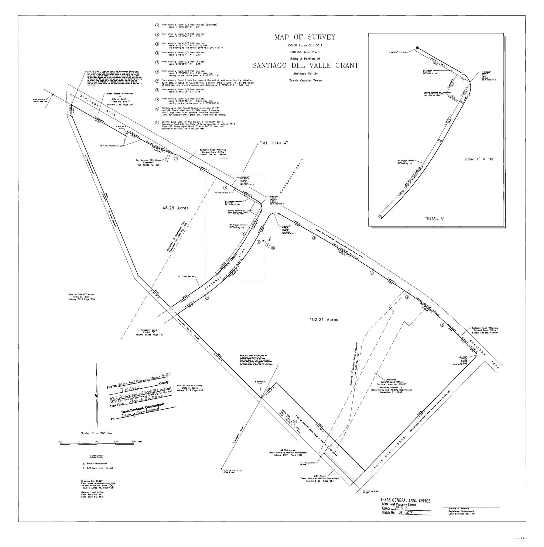
Travis County State Real Property Sketch 15
A map of a survey of 150.50 acres out of a 309.157 acre tract being a portion of Santiago Del Valle Grant , A - 24
State Real Property Sketch S - 27
-
Map/Doc
61674
-
Collection
General Map Collection
-
Object Dates
1995 (Creation Date)
2002/3/28 (File Date)
-
People and Organizations
Jimmie D. Flowers (Surveyor/Engineer)
-
Counties
Travis
-
Subjects
State Real Property
-
Height x Width
29.6 x 29.5 inches
75.2 x 74.9 cm
-
Comments
Surveys located about four and one half miles South 12 degrees East of Austin, Texas.
Part of: General Map Collection

Bell County Sketch File 34

Print $40.00
- Digital $50.00
Bell County Sketch File 34
Size 15.4 x 13.4 inches
Map/Doc 14455
Cottle County Working Sketch 7

Print $20.00
- Digital $50.00
Cottle County Working Sketch 7
1916
Size 28.4 x 30.4 inches
Map/Doc 68317
Flight Mission No. DQO-3K, Frame 87, Galveston County

Print $20.00
- Digital $50.00
Flight Mission No. DQO-3K, Frame 87, Galveston County
1952
Size 18.7 x 22.4 inches
Map/Doc 85092
Fort Bend County State Real Property Sketch 18

Print $40.00
- Digital $50.00
Fort Bend County State Real Property Sketch 18
2006
Size 17.7 x 24.0 inches
Map/Doc 88615
[Surveys in Austin's Colony along the Yegua River and Cedar Creek]
![67, [Surveys in Austin's Colony along the Yegua River and Cedar Creek], General Map Collection](https://historictexasmaps.com/wmedia_w700/maps/67.tif.jpg)
Print $20.00
- Digital $50.00
[Surveys in Austin's Colony along the Yegua River and Cedar Creek]
1835
Size 15.7 x 19.3 inches
Map/Doc 67
Culberson County Working Sketch 1

Print $20.00
- Digital $50.00
Culberson County Working Sketch 1
Size 21.6 x 42.7 inches
Map/Doc 68453
Matagorda County Rolled Sketch 37A

Print $40.00
- Digital $50.00
Matagorda County Rolled Sketch 37A
Size 48.7 x 41.1 inches
Map/Doc 10195
Blanco County Sketch File 23

Print $16.00
- Digital $50.00
Blanco County Sketch File 23
1887
Size 8.7 x 14.1 inches
Map/Doc 14606
Aransas County Sketch File 38

Print $244.00
- Digital $50.00
Aransas County Sketch File 38
1996
Size 11.1 x 8.7 inches
Map/Doc 13465
Montgomery County Working Sketch 42

Print $20.00
- Digital $50.00
Montgomery County Working Sketch 42
1956
Size 21.3 x 32.8 inches
Map/Doc 71149
Liberty County Sketch File M

Print $20.00
- Digital $50.00
Liberty County Sketch File M
1879
Size 16.9 x 14.5 inches
Map/Doc 12000
You may also like
Hill County Sketch File 17

Print $4.00
- Digital $50.00
Hill County Sketch File 17
1860
Size 12.5 x 8.3 inches
Map/Doc 26484
Montgomery County Rolled Sketch 13A

Print $20.00
- Digital $50.00
Montgomery County Rolled Sketch 13A
1932
Size 17.7 x 27.5 inches
Map/Doc 6802
Brown County Working Sketch 11

Print $20.00
- Digital $50.00
Brown County Working Sketch 11
1983
Size 45.5 x 43.1 inches
Map/Doc 67776
Bexar County Sketch File 58

Print $4.00
- Digital $50.00
Bexar County Sketch File 58
1847
Size 10.4 x 8.3 inches
Map/Doc 14572
Map of Jefferson as owned by Allen Urquhart

Print $20.00
- Digital $50.00
Map of Jefferson as owned by Allen Urquhart
1850
Size 25.1 x 16.6 inches
Map/Doc 1684
Map of Fannin County

Print $20.00
- Digital $50.00
Map of Fannin County
1845
Size 34.7 x 47.0 inches
Map/Doc 87153
Menard County Boundary File 2a

Print $80.00
- Digital $50.00
Menard County Boundary File 2a
Size 36.4 x 12.2 inches
Map/Doc 57065
Flight Mission No. CUG-2P, Frame 60, Kleberg County

Print $20.00
- Digital $50.00
Flight Mission No. CUG-2P, Frame 60, Kleberg County
1956
Size 18.4 x 22.3 inches
Map/Doc 86197
Flight Mission No. BRA-16M, Frame 86, Jefferson County

Print $20.00
- Digital $50.00
Flight Mission No. BRA-16M, Frame 86, Jefferson County
1953
Size 18.5 x 22.3 inches
Map/Doc 85698
Collingsworth County Sketch File 7

Print $10.00
- Digital $50.00
Collingsworth County Sketch File 7
1915
Size 11.4 x 9.0 inches
Map/Doc 18884
McLennan County Sketch File 2

Print $6.00
- Digital $50.00
McLennan County Sketch File 2
1856
Size 11.5 x 7.7 inches
Map/Doc 31230
Crane County Sketch File 5

Print $6.00
- Digital $50.00
Crane County Sketch File 5
1886
Size 14.3 x 8.6 inches
Map/Doc 19564