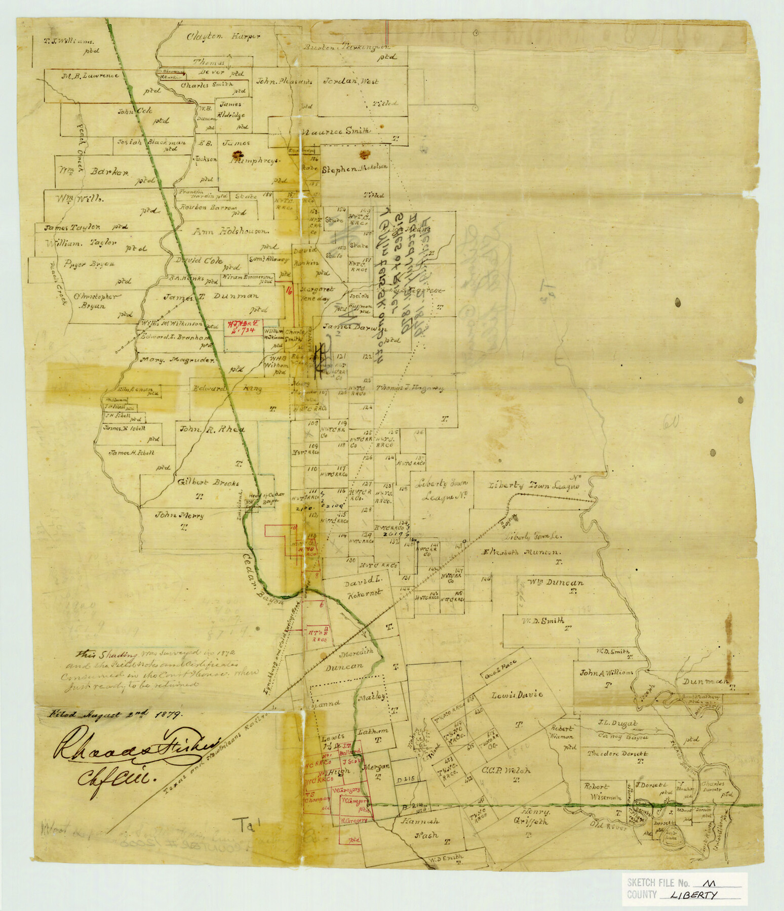
Liberty County Sketch File M
Sketch on Both Sides of [Cedar Bayou] River, Liberty County, Texas
-
Map/Doc
12000
-
Collection
General Map Collection
-
Object Dates
7/31/1879 (Creation Date)
8/2/1879 (File Date)
1872 (Survey Date)
-
People and Organizations
J.G. Minter (Surveyor/Engineer)
-
Counties
Liberty Chambers Harris Montgomery
-
Subjects
Surveying Sketch File
-
Height x Width
16.9 x 14.5 inches
42.9 x 36.8 cm
-
Medium
paper, manuscript
-
Features
Peach Creek
Cedar Bayou
Lake Island
Dayton
Liberty
Picket Bayou
Old River
Lynchburg and Cold Springs Road
T&NO
Lost Lake
Lost River
Part of: General Map Collection
Jackson County Rolled Sketch 3A

Print $20.00
- Digital $50.00
Jackson County Rolled Sketch 3A
1913
Size 23.2 x 22.6 inches
Map/Doc 6337
Hays County Working Sketch 9

Print $40.00
- Digital $50.00
Hays County Working Sketch 9
1949
Size 22.8 x 50.5 inches
Map/Doc 66083
Kimble County Working Sketch 65

Print $20.00
- Digital $50.00
Kimble County Working Sketch 65
1964
Size 22.1 x 17.0 inches
Map/Doc 70133
Glasscock County Working Sketch 16

Print $40.00
- Digital $50.00
Glasscock County Working Sketch 16
1984
Size 61.2 x 44.0 inches
Map/Doc 63189
Harris County Rolled Sketch WDC

Print $40.00
- Digital $50.00
Harris County Rolled Sketch WDC
1936
Size 42.7 x 68.4 inches
Map/Doc 9126
Flight Mission No. CRK-3P, Frame 130, Refugio County

Print $20.00
- Digital $50.00
Flight Mission No. CRK-3P, Frame 130, Refugio County
1956
Size 18.6 x 22.3 inches
Map/Doc 86918
County Map of Texas and Indian Territory

Print $20.00
- Digital $50.00
County Map of Texas and Indian Territory
1881
Size 13.1 x 9.9 inches
Map/Doc 94153
Titus County Boundary File 3

Print $6.00
- Digital $50.00
Titus County Boundary File 3
Size 7.6 x 6.9 inches
Map/Doc 59300
[Sketch for Mineral Application 27670 - Strip between Simon Sanchez leagues and Trinity River]
![2862, [Sketch for Mineral Application 27670 - Strip between Simon Sanchez leagues and Trinity River], General Map Collection](https://historictexasmaps.com/wmedia_w700/maps/2862-1.tif.jpg)
Print $20.00
- Digital $50.00
[Sketch for Mineral Application 27670 - Strip between Simon Sanchez leagues and Trinity River]
1934
Size 25.7 x 39.9 inches
Map/Doc 2862
Brewster County Working Sketch 10

Print $20.00
- Digital $50.00
Brewster County Working Sketch 10
1910
Size 17.8 x 16.8 inches
Map/Doc 67543
Sabine River, Toll Bridge Sheet

Print $40.00
- Digital $50.00
Sabine River, Toll Bridge Sheet
1933
Size 27.8 x 51.9 inches
Map/Doc 65136
Current Miscellaneous File 8

Print $10.00
- Digital $50.00
Current Miscellaneous File 8
Size 14.6 x 9.1 inches
Map/Doc 73736
You may also like
Starr County Working Sketch Graphic Index

Print $40.00
- Digital $50.00
Starr County Working Sketch Graphic Index
1977
Size 43.0 x 55.5 inches
Map/Doc 76701
San Augustine County Working Sketch 9

Print $20.00
- Digital $50.00
San Augustine County Working Sketch 9
1935
Size 41.2 x 39.7 inches
Map/Doc 63696
Angelina County Sketch File 29

Print $4.00
- Digital $50.00
Angelina County Sketch File 29
1911
Size 8.0 x 8.4 inches
Map/Doc 13087
Flight Mission No. DQN-7K, Frame 35, Calhoun County

Print $20.00
- Digital $50.00
Flight Mission No. DQN-7K, Frame 35, Calhoun County
1953
Size 18.5 x 22.1 inches
Map/Doc 84473
Wise County Sketch File 31

Print $12.00
- Digital $50.00
Wise County Sketch File 31
1877
Size 13.1 x 8.1 inches
Map/Doc 40582
Cochran County Boundary File 1a

Print $10.00
- Digital $50.00
Cochran County Boundary File 1a
Size 11.2 x 8.8 inches
Map/Doc 51461
El Paso County Boundary File 27

Print $2.00
- Digital $50.00
El Paso County Boundary File 27
Size 7.3 x 5.6 inches
Map/Doc 53236
Aransas County Sketch File 21

Print $2.00
- Digital $50.00
Aransas County Sketch File 21
Size 8.0 x 8.9 inches
Map/Doc 13157
Comanche County Sketch File 26

Print $20.00
- Digital $50.00
Comanche County Sketch File 26
Size 18.0 x 17.5 inches
Map/Doc 11144
Reagan County Working Sketch 40

Print $20.00
- Digital $50.00
Reagan County Working Sketch 40
1973
Size 31.7 x 28.6 inches
Map/Doc 71882
Culberson County Sketch File 28

Print $4.00
- Digital $50.00
Culberson County Sketch File 28
1949
Size 14.5 x 9.0 inches
Map/Doc 20280
Liberty County Sketch File 24

Print $6.00
- Digital $50.00
Liberty County Sketch File 24
Size 10.2 x 7.9 inches
Map/Doc 29936