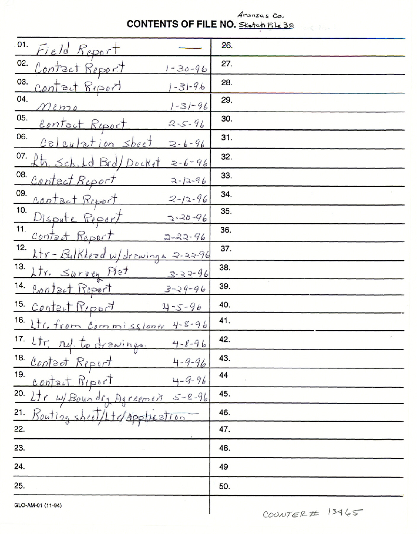
Aransas County Sketch File 38
[Field reports and boundary agreement regarding Copano Bay State Tract no. 12]
-
Map/Doc
13465
-
Collection
General Map Collection
-
Object Dates
1996/4/11 (File Date)
1996 (Creation Date)
-
People and Organizations
Garry Mauro (GLO Commissioner)
J.L. Brundrett, Jr. (Surveyor/Engineer)
-
Counties
Aransas
-
Subjects
Surveying Sketch File
-
Height x Width
11.1 x 8.7 inches
28.2 x 22.1 cm
-
Medium
paper, photocopy
-
Features
West Shady Oak Drive
Goose Island State Park
Copano Bay Causeway State Park
Shell Point
Newcomb Point
Newcomb Bend
Palmetto Point
Texas Highway 35
Northview Drive
[Road to] Rockport
[Road to] Fulton
[Road to] Tivoli
Copano Bay
Shady Oak Drive
Sherwood Drive
Mesquite Tree [Drive]
Hillcrest Drive
Northside Drive
Northwest Drive
Aransas Bay
LBJ Causeway
Fulton Airport
Belaire Drive
Holiday Beach Subdivision
Part of: General Map Collection
Gaines County Working Sketch 23

Print $20.00
- Digital $50.00
Gaines County Working Sketch 23
1982
Size 29.1 x 41.8 inches
Map/Doc 69323
Webb County Working Sketch 74

Print $20.00
- Digital $50.00
Webb County Working Sketch 74
1975
Size 17.0 x 30.0 inches
Map/Doc 72441
Bowie County Sketch File 7c

Print $7.00
- Digital $50.00
Bowie County Sketch File 7c
Size 11.9 x 7.4 inches
Map/Doc 14864

Houston Ship Channel, Alexander Island to Carpenter Bayou

Print $20.00
- Digital $50.00
Houston Ship Channel, Alexander Island to Carpenter Bayou
1960
Size 34.8 x 46.2 inches
Map/Doc 69906
El Paso County Rolled Sketch 43A

Print $20.00
- Digital $50.00
El Paso County Rolled Sketch 43A
Size 23.2 x 22.6 inches
Map/Doc 5829
Val Verde County Sketch File XXX9

Print $4.00
- Digital $50.00
Val Verde County Sketch File XXX9
Size 11.0 x 8.5 inches
Map/Doc 39108
Mosaic composed of aerial photographs - Houston Ship Channel, Tex.

Print $20.00
- Digital $50.00
Mosaic composed of aerial photographs - Houston Ship Channel, Tex.
1923
Size 13.7 x 38.0 inches
Map/Doc 97172
Montague County Sketch File 4

Print $22.00
- Digital $50.00
Montague County Sketch File 4
1855
Size 12.7 x 16.1 inches
Map/Doc 31715
[Surveys in Williamson County]
![78374, [Surveys in Williamson County], General Map Collection](https://historictexasmaps.com/wmedia_w700/maps/78374.tif.jpg)
Print $2.00
- Digital $50.00
[Surveys in Williamson County]
1846
Size 9.2 x 11.8 inches
Map/Doc 78374

Texas 1971 Official State Highway Map

Digital $50.00
Texas 1971 Official State Highway Map
Size 28.3 x 36.5 inches
Map/Doc 94316
You may also like
Jefferson County Sketch File 6

Print $4.00
- Digital $50.00
Jefferson County Sketch File 6
1860
Size 12.3 x 7.8 inches
Map/Doc 28110
General Highway Map, Brazoria County, Texas

Print $20.00
General Highway Map, Brazoria County, Texas
1961
Size 25.0 x 18.2 inches
Map/Doc 79382
Hemphill County Working Sketch 9

Print $20.00
- Digital $50.00
Hemphill County Working Sketch 9
1965
Size 23.0 x 32.8 inches
Map/Doc 66104


[Galveston, Harrisburg & San Antonio Railroad from Cuero to Stockdale]
![64200, [Galveston, Harrisburg & San Antonio Railroad from Cuero to Stockdale], General Map Collection](https://historictexasmaps.com/wmedia_w700/maps/64200.tif.jpg)
Print $20.00
- Digital $50.00
[Galveston, Harrisburg & San Antonio Railroad from Cuero to Stockdale]
1907
Size 14.0 x 34.1 inches
Map/Doc 64200
Nueces County Rolled Sketch 103

Print $105.00
Nueces County Rolled Sketch 103
1985
Size 36.5 x 24.1 inches
Map/Doc 7078
Sutton County Working Sketch 48

Print $20.00
- Digital $50.00
Sutton County Working Sketch 48
1955
Size 34.8 x 33.1 inches
Map/Doc 62391
Polk County Working Sketch 22

Print $40.00
- Digital $50.00
Polk County Working Sketch 22
1957
Size 43.0 x 64.6 inches
Map/Doc 71637
Borden County Sketch File 10a

Print $40.00
- Digital $50.00
Borden County Sketch File 10a
Size 21.0 x 37.5 inches
Map/Doc 10935
[Block 37, Townships 1 and 2 North]
![91344, [Block 37, Townships 1 and 2 North], Twichell Survey Records](https://historictexasmaps.com/wmedia_w700/maps/91344-1.tif.jpg)
Print $20.00
- Digital $50.00
[Block 37, Townships 1 and 2 North]
Size 13.9 x 34.3 inches
Map/Doc 91344
Gaines County Sketch File 11

Print $6.00
- Digital $50.00
Gaines County Sketch File 11
1943
Size 7.3 x 8.9 inches
Map/Doc 23195