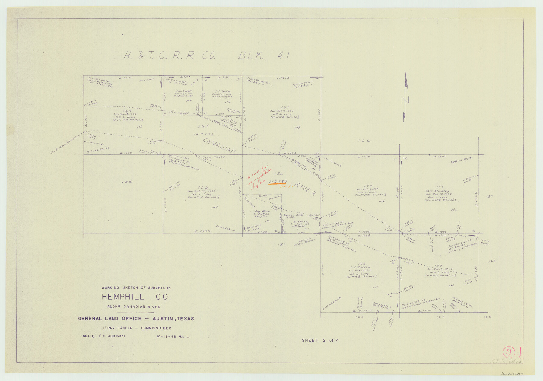
Hemphill County Working Sketch 9
-
Map/Doc
66104
-
Collection
General Map Collection
-
Object Dates
12/15/1965 (Creation Date)
-
People and Organizations
M. L. Liles (Draftsman)
-
Counties
Hemphill
-
Subjects
Surveying Working Sketch
-
Height x Width
23.0 x 32.8 inches
58.4 x 83.3 cm
-
Scale
1" = 400 varas
Part of: General Map Collection
Live Oak County Working Sketch 21

Print $20.00
- Digital $50.00
Live Oak County Working Sketch 21
1964
Size 30.8 x 33.9 inches
Map/Doc 70606
Bee County Working Sketch 16

Print $20.00
- Digital $50.00
Bee County Working Sketch 16
1974
Size 18.0 x 19.6 inches
Map/Doc 67266
Garza County Rolled Sketch 11B

Print $20.00
- Digital $50.00
Garza County Rolled Sketch 11B
1915
Size 24.6 x 24.8 inches
Map/Doc 6001
Polk County Sketch File 44

Print $193.00
- Digital $50.00
Polk County Sketch File 44
1958
Size 9.4 x 11.0 inches
Map/Doc 34297
Flight Mission No. DQN-1K, Frame 143, Calhoun County

Print $20.00
- Digital $50.00
Flight Mission No. DQN-1K, Frame 143, Calhoun County
1953
Size 18.5 x 22.1 inches
Map/Doc 84206
Reeves County Sketch File 20

Print $8.00
- Digital $50.00
Reeves County Sketch File 20
1943
Size 9.9 x 8.5 inches
Map/Doc 35216
Foard County Sketch File 9

Print $20.00
- Digital $50.00
Foard County Sketch File 9
1882
Size 19.7 x 17.1 inches
Map/Doc 11492
Sterling County Sketch File A

Print $20.00
- Digital $50.00
Sterling County Sketch File A
1906
Size 18.2 x 26.0 inches
Map/Doc 12362
Hardin County Working Sketch 24

Print $20.00
- Digital $50.00
Hardin County Working Sketch 24
1950
Size 15.3 x 11.9 inches
Map/Doc 63422
Hutchinson County Sketch File 44

Print $82.00
- Digital $50.00
Hutchinson County Sketch File 44
1989
Size 11.2 x 9.0 inches
Map/Doc 27311
Flight Mission No. CUG-3P, Frame 38, Kleberg County

Print $20.00
- Digital $50.00
Flight Mission No. CUG-3P, Frame 38, Kleberg County
1956
Size 18.5 x 22.3 inches
Map/Doc 86243
Reeves County Working Sketch 16

Print $40.00
- Digital $50.00
Reeves County Working Sketch 16
1961
Size 30.8 x 48.8 inches
Map/Doc 63459
You may also like
Burnet County Working Sketch 12

Print $20.00
- Digital $50.00
Burnet County Working Sketch 12
1976
Size 17.3 x 19.9 inches
Map/Doc 67855
Potter County Rolled Sketch 5

Print $40.00
- Digital $50.00
Potter County Rolled Sketch 5
1903
Size 56.0 x 21.9 inches
Map/Doc 9759
Flight Mission No. DIX-7P, Frame 15, Aransas County

Print $20.00
- Digital $50.00
Flight Mission No. DIX-7P, Frame 15, Aransas County
1956
Size 18.8 x 22.8 inches
Map/Doc 83867
Flight Mission No. BRE-2P, Frame 73, Nueces County

Print $20.00
- Digital $50.00
Flight Mission No. BRE-2P, Frame 73, Nueces County
1956
Size 18.5 x 22.5 inches
Map/Doc 86768
General Highway Map, Clay County, Texas

Print $20.00
General Highway Map, Clay County, Texas
1940
Size 25.2 x 18.6 inches
Map/Doc 79047
Nueces County Sketch File A

Print $10.00
- Digital $50.00
Nueces County Sketch File A
1879
Size 14.9 x 10.3 inches
Map/Doc 32493
Flight Mission No. DIX-10P, Frame 176, Aransas County

Print $20.00
- Digital $50.00
Flight Mission No. DIX-10P, Frame 176, Aransas County
1956
Size 18.6 x 22.3 inches
Map/Doc 83966
Ward County Working Sketch 34

Print $20.00
- Digital $50.00
Ward County Working Sketch 34
1968
Size 26.7 x 30.5 inches
Map/Doc 72340
Montgomery County Working Sketch 55

Print $20.00
- Digital $50.00
Montgomery County Working Sketch 55
1961
Size 23.8 x 34.6 inches
Map/Doc 71162
Marshall Ford Dam right of way survey, General Ownership Map

Print $40.00
- Digital $50.00
Marshall Ford Dam right of way survey, General Ownership Map
1942
Size 36.6 x 55.9 inches
Map/Doc 60402
Newton County Rolled Sketch 17

Print $20.00
- Digital $50.00
Newton County Rolled Sketch 17
1955
Size 34.5 x 47.1 inches
Map/Doc 6847
Aransas County Sketch File 14a

Print $40.00
- Digital $50.00
Aransas County Sketch File 14a
1891
Size 16.7 x 15.8 inches
Map/Doc 10821