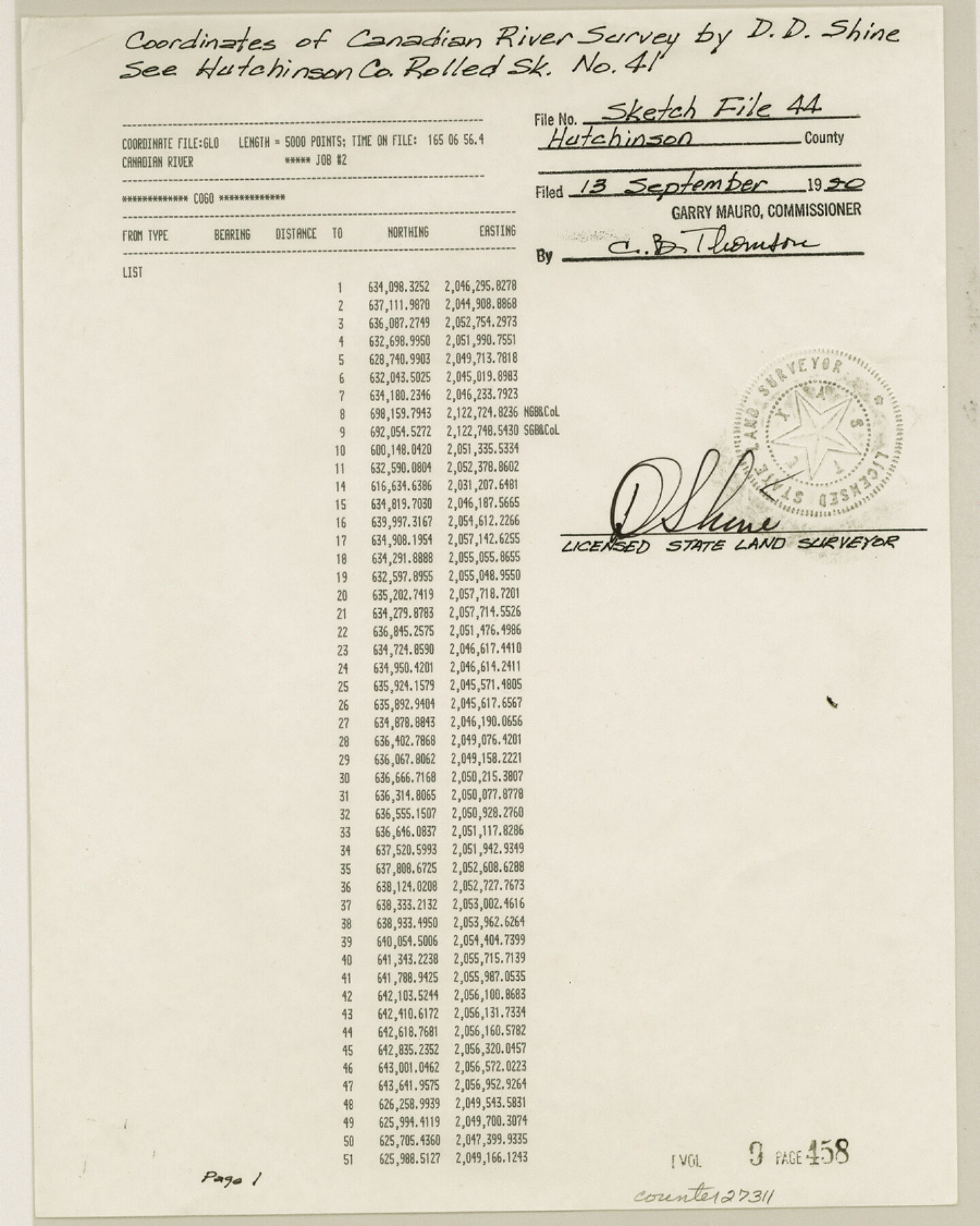
Hutchinson County Sketch File 44
[Coordinates of Canadian River Gradient Boundary Survey by D.D. Shine]
-
Map/Doc
27311
-
Collection
General Map Collection
-
Object Dates
2/1989 (Creation Date)
9/13/1990 (File Date)
-
People and Organizations
Darrell D. Shine (Surveyor/Engineer)
-
Counties
Hutchinson
-
Subjects
Surveying Sketch File
-
Height x Width
11.2 x 9.0 inches
28.4 x 22.9 cm
-
Medium
paper, print
-
Comments
See Hutchinson County Rolled Sketch 41 (9249), Hutchinson County Sketch File 45 (27354), and Hutchinson County Sketch File 48 (27400).
Related maps
Hutchinson County Sketch File 44a

Print $4.00
- Digital $50.00
Hutchinson County Sketch File 44a
1989
Size 11.2 x 8.7 inches
Map/Doc 27352
Hutchinson County Sketch File 45

Print $22.00
- Digital $50.00
Hutchinson County Sketch File 45
1991
Size 11.1 x 8.8 inches
Map/Doc 27354
Hutchinson County Sketch File 48

Print $38.00
- Digital $50.00
Hutchinson County Sketch File 48
1989
Size 11.2 x 8.8 inches
Map/Doc 27400
Hutchinson County Rolled Sketch 41

Print $40.00
- Digital $50.00
Hutchinson County Rolled Sketch 41
1989
Size 43.3 x 144.5 inches
Map/Doc 9249
Part of: General Map Collection
Shelby County Sketch File 26

Print $4.00
- Digital $50.00
Shelby County Sketch File 26
Size 8.1 x 8.1 inches
Map/Doc 36660
Nueces County NRC Article 33.136 Sketch 11

Print $20.00
- Digital $50.00
Nueces County NRC Article 33.136 Sketch 11
2000
Size 25.8 x 43.0 inches
Map/Doc 84334
Richardson's New Map of the State of Texas, corrected for the Texas Almanac to 1872

Print $20.00
- Digital $50.00
Richardson's New Map of the State of Texas, corrected for the Texas Almanac to 1872
1872
Size 18.4 x 26.4 inches
Map/Doc 93647
Trinity County Working Sketch 12

Print $20.00
- Digital $50.00
Trinity County Working Sketch 12
1950
Size 46.6 x 36.9 inches
Map/Doc 69461
Map of the City of Aransas Pass

Print $20.00
- Digital $50.00
Map of the City of Aransas Pass
1905
Size 28.3 x 21.4 inches
Map/Doc 97266
Flight Mission No. DQN-2K, Frame 9, Calhoun County

Print $20.00
- Digital $50.00
Flight Mission No. DQN-2K, Frame 9, Calhoun County
1953
Size 15.7 x 15.6 inches
Map/Doc 84226
Anderson County Working Sketch Graphic Index

Print $40.00
- Digital $50.00
Anderson County Working Sketch Graphic Index
1942
Size 52.0 x 48.3 inches
Map/Doc 76452
Flight Mission No. CGI-2N, Frame 154, Cameron County

Print $20.00
- Digital $50.00
Flight Mission No. CGI-2N, Frame 154, Cameron County
1954
Size 18.6 x 19.0 inches
Map/Doc 84536
Zapata County Working Sketch 20

Print $20.00
- Digital $50.00
Zapata County Working Sketch 20
1979
Size 20.9 x 18.5 inches
Map/Doc 62071
Harris County Boundary File 2

Print $8.00
- Digital $50.00
Harris County Boundary File 2
Size 8.1 x 8.7 inches
Map/Doc 54294
Travis County Rolled Sketch 32A

Print $40.00
- Digital $50.00
Travis County Rolled Sketch 32A
Size 57.6 x 37.3 inches
Map/Doc 10013
Zavala County Working Sketch 19

Print $40.00
- Digital $50.00
Zavala County Working Sketch 19
1978
Size 16.2 x 59.1 inches
Map/Doc 62094
You may also like
Packery Channel

Print $20.00
- Digital $50.00
Packery Channel
1975
Size 27.8 x 30.9 inches
Map/Doc 2994
Callahan County Sketch File 16

Print $4.00
- Digital $50.00
Callahan County Sketch File 16
Size 14.6 x 8.7 inches
Map/Doc 35895
North America in the Age of Dinosaurs

North America in the Age of Dinosaurs
1993
Size 27.4 x 20.8 inches
Map/Doc 96831
Roberts County Working Sketch 18

Print $20.00
- Digital $50.00
Roberts County Working Sketch 18
1975
Size 35.6 x 39.7 inches
Map/Doc 63544
Leon County Rolled Sketch 31

Print $20.00
- Digital $50.00
Leon County Rolled Sketch 31
1990
Size 44.5 x 32.7 inches
Map/Doc 6614
Flight Mission No. BRE-2P, Frame 100, Nueces County

Print $20.00
- Digital $50.00
Flight Mission No. BRE-2P, Frame 100, Nueces County
1956
Size 18.5 x 22.3 inches
Map/Doc 86785
Chambers County Sketch File 18b

Print $15.00
- Digital $50.00
Chambers County Sketch File 18b
1901
Size 9.2 x 8.1 inches
Map/Doc 17571
Brazoria County Rolled Sketch 25B

Print $261.00
- Digital $50.00
Brazoria County Rolled Sketch 25B
Size 28.0 x 15.8 inches
Map/Doc 42752
Intracoastal Waterway in Texas - Corpus Christi to Point Isabel including Arroyo Colorado to Mo. Pac. R.R. Bridge Near Harlingen

Print $20.00
- Digital $50.00
Intracoastal Waterway in Texas - Corpus Christi to Point Isabel including Arroyo Colorado to Mo. Pac. R.R. Bridge Near Harlingen
1934
Size 22.1 x 32.7 inches
Map/Doc 61887
Coleman County Working Sketch 5

Print $20.00
- Digital $50.00
Coleman County Working Sketch 5
1928
Size 27.0 x 25.6 inches
Map/Doc 68071
Dallas County Boundary File 6

Print $10.00
- Digital $50.00
Dallas County Boundary File 6
Size 11.1 x 8.5 inches
Map/Doc 52184
[Map of Chicago, Rock Island & Texas Railway through Tarrant County, Texas]
![64413, [Map of Chicago, Rock Island & Texas Railway through Tarrant County, Texas], General Map Collection](https://historictexasmaps.com/wmedia_w700/maps/64413.tif.jpg)
Print $40.00
- Digital $50.00
[Map of Chicago, Rock Island & Texas Railway through Tarrant County, Texas]
1893
Size 22.3 x 121.8 inches
Map/Doc 64413