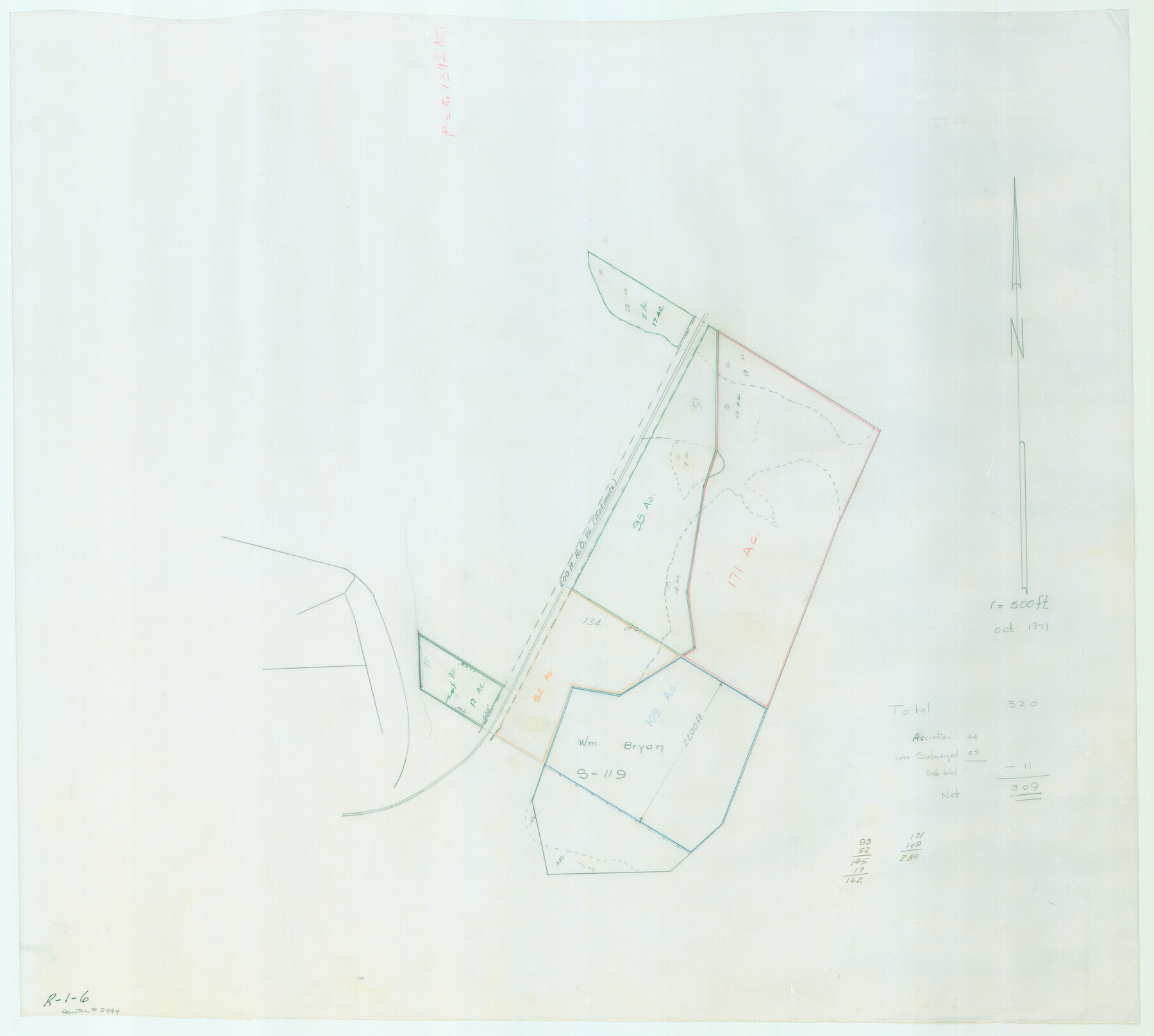
Packery Channel
-
Map/Doc
2994
-
Collection
General Map Collection
-
Object Dates
1975 (Creation Date)
-
People and Organizations
General Land Office (Publisher)
-
Counties
Nueces
-
Subjects
Aerial Photograph
-
Height x Width
27.8 x 30.9 inches
70.6 x 78.5 cm
-
Medium
vellum, penciled
-
Scale
500 feet
-
Comments
Analysis of accretion to Wm. Bryan, Refugio S-119.
Part of: General Map Collection
Bandera County Sketch File 19

Print $40.00
- Digital $50.00
Bandera County Sketch File 19
Size 15.9 x 18.9 inches
Map/Doc 10893
Jim Wells County Working Sketch 11

Print $20.00
- Digital $50.00
Jim Wells County Working Sketch 11
1953
Size 20.4 x 22.6 inches
Map/Doc 66609
Jack County Working Sketch 13

Print $20.00
- Digital $50.00
Jack County Working Sketch 13
1975
Size 25.5 x 35.8 inches
Map/Doc 66439
Webb County Working Sketch 2

Print $20.00
- Digital $50.00
Webb County Working Sketch 2
1906
Size 11.2 x 12.5 inches
Map/Doc 72367
Kerr County Working Sketch 27

Print $20.00
- Digital $50.00
Kerr County Working Sketch 27
1970
Size 25.4 x 20.8 inches
Map/Doc 70058
Yoakum County Sketch File 17

Print $48.00
- Digital $50.00
Yoakum County Sketch File 17
1898
Size 14.5 x 8.9 inches
Map/Doc 40796
Flight Mission No. DAG-24K, Frame 44, Matagorda County

Print $20.00
- Digital $50.00
Flight Mission No. DAG-24K, Frame 44, Matagorda County
1953
Size 16.0 x 15.9 inches
Map/Doc 86531
Pecos County Rolled Sketch 174

Print $20.00
- Digital $50.00
Pecos County Rolled Sketch 174
Size 23.3 x 25.0 inches
Map/Doc 7294
National Map Company's Map of Texas showing counties, cities, towns, villages and post offices, steam and electric railways with stations and distance between stations

Print $40.00
- Digital $50.00
National Map Company's Map of Texas showing counties, cities, towns, villages and post offices, steam and electric railways with stations and distance between stations
1920
Size 49.1 x 50.3 inches
Map/Doc 10750
Sketch showing the route of the military road from Red River to Austin

Print $20.00
- Digital $50.00
Sketch showing the route of the military road from Red River to Austin
1840
Size 33.2 x 13.1 inches
Map/Doc 1752
Louisiana and Texas Intracoastal Waterway - Dredging Tributary Channel, Port Aransas to Aransas Pass, Texas

Print $20.00
- Digital $50.00
Louisiana and Texas Intracoastal Waterway - Dredging Tributary Channel, Port Aransas to Aransas Pass, Texas
1940
Size 31.1 x 42.3 inches
Map/Doc 61820
Jones County Sketch File 16

Print $20.00
- Digital $50.00
Jones County Sketch File 16
1945
Size 23.7 x 19.0 inches
Map/Doc 11901
You may also like
El Paso County Rolled Sketch 52

Print $20.00
- Digital $50.00
El Paso County Rolled Sketch 52
1929
Size 18.4 x 24.4 inches
Map/Doc 5845
Bell County Working Sketch 19

Print $40.00
- Digital $50.00
Bell County Working Sketch 19
1994
Size 48.3 x 38.4 inches
Map/Doc 67359
Flight Mission No. CUG-3P, Frame 193, Kleberg County

Print $20.00
- Digital $50.00
Flight Mission No. CUG-3P, Frame 193, Kleberg County
1956
Size 18.4 x 22.3 inches
Map/Doc 86297
Flight Mission No. BRE-2P, Frame 134, Nueces County

Print $20.00
- Digital $50.00
Flight Mission No. BRE-2P, Frame 134, Nueces County
1956
Size 18.4 x 22.3 inches
Map/Doc 86807
Zavala County Boundary File 1

Print $48.00
- Digital $50.00
Zavala County Boundary File 1
Size 12.8 x 8.3 inches
Map/Doc 60233
Howard County Rolled Sketch 4

Print $20.00
- Digital $50.00
Howard County Rolled Sketch 4
1909
Size 35.6 x 27.4 inches
Map/Doc 6233
Dinsmore & Company's New and Complete Map of the Railway System of the United States and Canada compiled from official sources, under the direction of the editor of the "American Railway Guide"

Print $20.00
- Digital $50.00
Dinsmore & Company's New and Complete Map of the Railway System of the United States and Canada compiled from official sources, under the direction of the editor of the "American Railway Guide"
1855
Size 16.3 x 20.4 inches
Map/Doc 95903
[Sketch for Mineral Application 26501 - Sabine River, T. A. Oldhausen]
![2835, [Sketch for Mineral Application 26501 - Sabine River, T. A. Oldhausen], General Map Collection](https://historictexasmaps.com/wmedia_w700/maps/2835.tif.jpg)
Print $20.00
- Digital $50.00
[Sketch for Mineral Application 26501 - Sabine River, T. A. Oldhausen]
1931
Size 24.6 x 36.6 inches
Map/Doc 2835

The Republic County of Colorado. January 29, 1842

Print $20.00
The Republic County of Colorado. January 29, 1842
2020
Size 18.4 x 21.7 inches
Map/Doc 96125
Flight Mission No. DCL-6C, Frame 118, Kenedy County

Print $20.00
- Digital $50.00
Flight Mission No. DCL-6C, Frame 118, Kenedy County
1943
Size 18.6 x 22.4 inches
Map/Doc 85948
