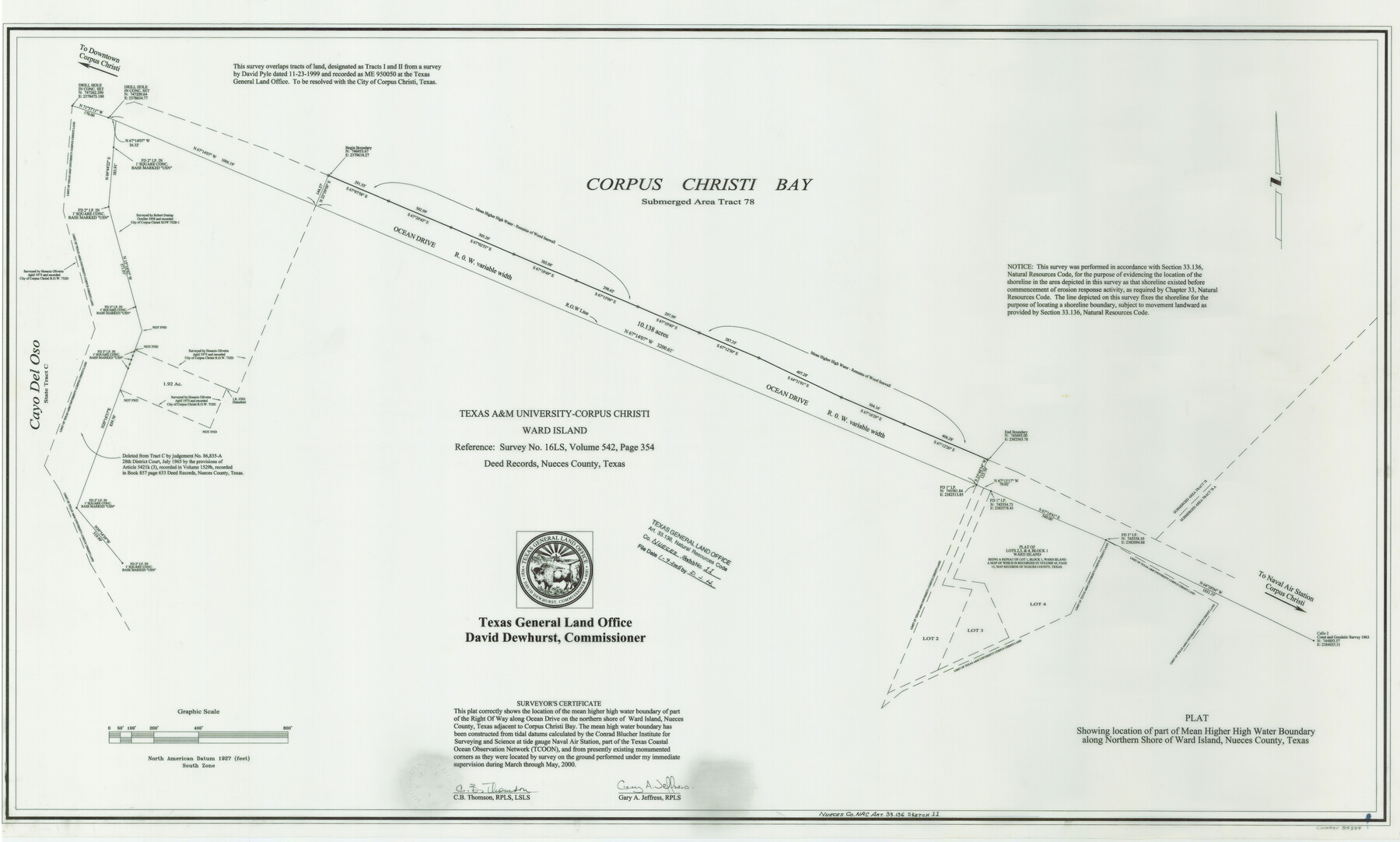
Nueces County NRC Article 33.136 Sketch 11
A Plat Showing Location of Part of Mean Higher High Water Boundary Along Northern Shore of Ward Island, Nueces County
-
Map/Doc
84334
-
Collection
General Map Collection
-
Object Dates
2000 (Creation Date)
2006/1/9 (File Date)
-
People and Organizations
Texas General Land Office (Publisher)
Texas General Land Office (Printer)
David Dewhurst (GLO Commissioner)
Gary A. Jeffress (Surveyor/Engineer)
C.B. Thomson (Surveyor/Engineer)
-
Counties
Nueces
-
Subjects
Surveying CBS
-
Height x Width
25.8 x 43.0 inches
65.5 x 109.2 cm
-
Medium
mylar, print
-
Comments
Survey located about seven miles South 38 degrees East of Corpus Christi, Texas.
Part of: General Map Collection
Polk County Sketch File 30

Print $18.00
- Digital $50.00
Polk County Sketch File 30
1934
Size 14.1 x 8.5 inches
Map/Doc 34206
Trinity River, Emhouse Sheet/Chambers Creek

Print $20.00
- Digital $50.00
Trinity River, Emhouse Sheet/Chambers Creek
1931
Size 35.8 x 35.3 inches
Map/Doc 65233
Bexar County Working Sketch 15

Print $20.00
- Digital $50.00
Bexar County Working Sketch 15
1972
Size 38.3 x 43.3 inches
Map/Doc 67331
Flight Mission No. CUG-2P, Frame 62, Kleberg County

Print $20.00
- Digital $50.00
Flight Mission No. CUG-2P, Frame 62, Kleberg County
1956
Size 18.5 x 18.5 inches
Map/Doc 86199
Crockett County Rolled Sketch 64

Print $20.00
- Digital $50.00
Crockett County Rolled Sketch 64
1947
Size 19.8 x 41.2 inches
Map/Doc 5607
Flight Mission No. DCL-4C, Frame 145, Kenedy County

Print $20.00
- Digital $50.00
Flight Mission No. DCL-4C, Frame 145, Kenedy County
1943
Size 18.6 x 22.4 inches
Map/Doc 85823
Parker County Working Sketch Graphic Index

Print $20.00
- Digital $50.00
Parker County Working Sketch Graphic Index
1942
Map/Doc 76661
Lavaca County Working Sketch 14

Print $20.00
- Digital $50.00
Lavaca County Working Sketch 14
1962
Size 28.4 x 29.7 inches
Map/Doc 70367
Schleicher County Working Sketch 7

Print $20.00
- Digital $50.00
Schleicher County Working Sketch 7
1923
Size 22.4 x 14.7 inches
Map/Doc 63809
Motley County

Print $20.00
- Digital $50.00
Motley County
1966
Size 41.2 x 32.1 inches
Map/Doc 77380
Flight Mission No. CZW-1R, Frame 165, Hardeman County

Print $20.00
- Digital $50.00
Flight Mission No. CZW-1R, Frame 165, Hardeman County
1956
Size 18.7 x 22.4 inches
Map/Doc 85236
Tyler County Sketch File 2a

Print $11.00
- Digital $50.00
Tyler County Sketch File 2a
1851
Size 8.3 x 7.8 inches
Map/Doc 38617
You may also like
Fort Bend County Working Sketch 8

Print $20.00
- Digital $50.00
Fort Bend County Working Sketch 8
1922
Size 24.9 x 17.6 inches
Map/Doc 69214
Controlled Mosaic by Jack Amman Photogrammetric Engineers, Inc - Sheet 43

Print $20.00
- Digital $50.00
Controlled Mosaic by Jack Amman Photogrammetric Engineers, Inc - Sheet 43
1954
Size 20.0 x 24.0 inches
Map/Doc 83502
Nueces County Aerial Photograph Index Sheet 21

Print $20.00
- Digital $50.00
Nueces County Aerial Photograph Index Sheet 21
1938
Size 24.3 x 20.2 inches
Map/Doc 86842
[Sketch for Mineral Application 13440]
![2799, [Sketch for Mineral Application 13440], General Map Collection](https://historictexasmaps.com/wmedia_w700/maps/2799-1.tif.jpg)
Print $20.00
- Digital $50.00
[Sketch for Mineral Application 13440]
1925
Size 24.3 x 54.0 inches
Map/Doc 2799
[North part of G. C. & S. F. Block OP, Runnels County School Land and Blks. AB, CD and GH]
![90310, [North part of G. C. & S. F. Block OP, Runnels County School Land and Blks. AB, CD and GH], Twichell Survey Records](https://historictexasmaps.com/wmedia_w700/maps/90310-1.tif.jpg)
Print $20.00
- Digital $50.00
[North part of G. C. & S. F. Block OP, Runnels County School Land and Blks. AB, CD and GH]
Size 17.5 x 22.4 inches
Map/Doc 90310
Working Sketch Crockett County

Print $20.00
- Digital $50.00
Working Sketch Crockett County
1924
Size 31.2 x 35.1 inches
Map/Doc 92608
Hutchinson County

Print $20.00
- Digital $50.00
Hutchinson County
Size 18.4 x 17.7 inches
Map/Doc 3695
Flight Mission No. BRA-8M, Frame 113, Jefferson County

Print $20.00
- Digital $50.00
Flight Mission No. BRA-8M, Frame 113, Jefferson County
1953
Size 18.6 x 22.3 inches
Map/Doc 85609
Map of Hill County

Print $40.00
- Digital $50.00
Map of Hill County
1884
Size 80.0 x 35.2 inches
Map/Doc 93379
Hall County Working Sketch 2

Print $40.00
- Digital $50.00
Hall County Working Sketch 2
1907
Size 40.9 x 48.4 inches
Map/Doc 63330
Alamo Defenders Heritage Map of Texas

Print $20.00
Alamo Defenders Heritage Map of Texas
2025
Size 36.0 x 24.0 inches
Map/Doc 97433
Johnson County Rolled Sketch 4

Print $20.00
- Digital $50.00
Johnson County Rolled Sketch 4
Size 24.8 x 36.0 inches
Map/Doc 94047