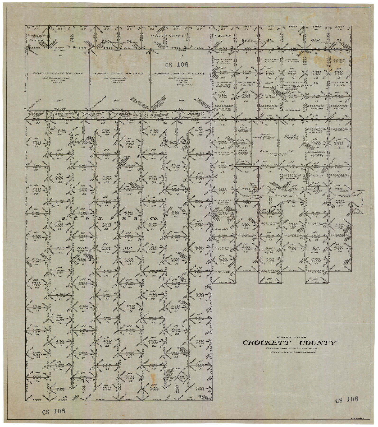
Working Sketch Crockett County
CS106
-
Map/Doc
92608
-
Collection
Twichell Survey Records
-
Object Dates
9/17/1924 (Creation Date)
-
Counties
Crockett
-
Height x Width
31.2 x 35.1 inches
79.3 x 89.2 cm
Part of: Twichell Survey Records
[T. & P. Block 44, Township 1S]
![90926, [T. & P. Block 44, Township 1S], Twichell Survey Records](https://historictexasmaps.com/wmedia_w700/maps/90926-1.tif.jpg)
Print $20.00
- Digital $50.00
[T. & P. Block 44, Township 1S]
Size 17.6 x 22.6 inches
Map/Doc 90926
[River Sections 58-62 and vicinity]
![91587, [River Sections 58-62 and vicinity], Twichell Survey Records](https://historictexasmaps.com/wmedia_w700/maps/91587-1.tif.jpg)
Print $20.00
- Digital $50.00
[River Sections 58-62 and vicinity]
Size 17.6 x 14.6 inches
Map/Doc 91587
Map of S. E. Pecos County with a part of Crockett County, Texas

Print $40.00
- Digital $50.00
Map of S. E. Pecos County with a part of Crockett County, Texas
1927
Size 42.2 x 51.6 inches
Map/Doc 89804
[Texas Boundary Line]
![92075, [Texas Boundary Line], Twichell Survey Records](https://historictexasmaps.com/wmedia_w700/maps/92075-1.tif.jpg)
Print $20.00
- Digital $50.00
[Texas Boundary Line]
Size 21.4 x 11.9 inches
Map/Doc 92075
A.W. Hudson Crosby County RR Line

Print $40.00
- Digital $50.00
A.W. Hudson Crosby County RR Line
Size 67.8 x 42.9 inches
Map/Doc 89760
[Surveys along San Antonio Road]
![90110, [Surveys along San Antonio Road], Twichell Survey Records](https://historictexasmaps.com/wmedia_w700/maps/90110-1.tif.jpg)
Print $20.00
- Digital $50.00
[Surveys along San Antonio Road]
Size 23.0 x 13.7 inches
Map/Doc 90110
[Stone, Kyle and Kyle Block M6]
![90394, [Stone, Kyle and Kyle Block M6], Twichell Survey Records](https://historictexasmaps.com/wmedia_w700/maps/90394-1.tif.jpg)
Print $20.00
- Digital $50.00
[Stone, Kyle and Kyle Block M6]
Size 19.7 x 22.5 inches
Map/Doc 90394
Hutchinson County

Print $20.00
- Digital $50.00
Hutchinson County
1884
Size 13.7 x 15.3 inches
Map/Doc 91137
[Townships 1, 2, 3, Blocks, 62, 61, 60, 59, 58, 57, 56]
![92884, [Townships 1, 2, 3, Blocks, 62, 61, 60, 59, 58, 57, 56], Twichell Survey Records](https://historictexasmaps.com/wmedia_w700/maps/92884-1.tif.jpg)
Print $20.00
- Digital $50.00
[Townships 1, 2, 3, Blocks, 62, 61, 60, 59, 58, 57, 56]
1885
Size 19.1 x 10.3 inches
Map/Doc 92884
Map of Terry County

Print $20.00
- Digital $50.00
Map of Terry County
Size 34.0 x 34.2 inches
Map/Doc 92933
[E. L. & R. R. RR. Co. Block D7 and G. H. & H. RR. Co. Block A1]
![91859, [E. L. & R. R. RR. Co. Block D7 and G. H. & H. RR. Co. Block A1], Twichell Survey Records](https://historictexasmaps.com/wmedia_w700/maps/91859-1.tif.jpg)
Print $20.00
- Digital $50.00
[E. L. & R. R. RR. Co. Block D7 and G. H. & H. RR. Co. Block A1]
Size 19.0 x 25.2 inches
Map/Doc 91859
[Garza, Blanco, Uvalde, and Crosby County School Lands]
![91197, [Garza, Blanco, Uvalde, and Crosby County School Lands], Twichell Survey Records](https://historictexasmaps.com/wmedia_w700/maps/91197-1.tif.jpg)
Print $20.00
- Digital $50.00
[Garza, Blanco, Uvalde, and Crosby County School Lands]
1913
Size 14.7 x 16.6 inches
Map/Doc 91197
You may also like
Map of Burleson County

Print $20.00
- Digital $50.00
Map of Burleson County
1856
Size 22.0 x 31.5 inches
Map/Doc 3345
Hardeman County Rolled Sketch 20

Print $40.00
- Digital $50.00
Hardeman County Rolled Sketch 20
Size 32.3 x 60.8 inches
Map/Doc 9102
Harrison County Sketch File 5

Print $4.00
- Digital $50.00
Harrison County Sketch File 5
1857
Size 8.1 x 9.9 inches
Map/Doc 26042
Galveston County Rolled Sketch 16

Print $20.00
- Digital $50.00
Galveston County Rolled Sketch 16
1952
Size 43.6 x 38.0 inches
Map/Doc 9078
Edwards County Working Sketch 77

Print $20.00
- Digital $50.00
Edwards County Working Sketch 77
1960
Size 32.8 x 39.9 inches
Map/Doc 68953
Fractional Township No. 8 South Range No. 2 West of the Indian Meridian, Indian Territory

Print $20.00
- Digital $50.00
Fractional Township No. 8 South Range No. 2 West of the Indian Meridian, Indian Territory
1898
Size 19.2 x 24.4 inches
Map/Doc 75196
Mississippi River to Galveston

Print $40.00
- Digital $50.00
Mississippi River to Galveston
1986
Size 36.8 x 49.9 inches
Map/Doc 69948
Travis County Rolled Sketch 34

Print $20.00
- Digital $50.00
Travis County Rolled Sketch 34
1949
Size 22.9 x 25.2 inches
Map/Doc 8035
Close-up: USA - The South Central States

Close-up: USA - The South Central States
1974
Size 23.2 x 35.2 inches
Map/Doc 96846
[Blocks B15, B8, B22]
![91981, [Blocks B15, B8, B22], Twichell Survey Records](https://historictexasmaps.com/wmedia_w700/maps/91981-1.tif.jpg)
Print $20.00
- Digital $50.00
[Blocks B15, B8, B22]
Size 22.9 x 9.9 inches
Map/Doc 91981
Milam County Working Sketch 14

Print $20.00
- Digital $50.00
Milam County Working Sketch 14
1904
Size 28.2 x 16.7 inches
Map/Doc 71029
Bowie County Sketch File 6e

Print $4.00
- Digital $50.00
Bowie County Sketch File 6e
1927
Size 11.2 x 8.4 inches
Map/Doc 14852