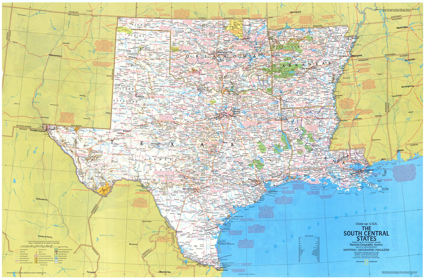
Close-up: USA - The South Central States
-
Map/Doc
96846
-
Collection
General Map Collection
-
Object Dates
10/1974 (Creation Date)
-
People and Organizations
Cartographic Division, National Geographic Society (Publisher)
Mark Lambert (Donor)
-
Subjects
Old Southwest
-
Height x Width
23.2 x 35.2 inches
58.9 x 89.4 cm
-
Medium
paper, print
-
Comments
For research only. Donated by Mark Lambert in May, 2022. See 96845 for recto.
Related maps
Close-up: USA - Arkansas, Oklahoma, Louisiana, Texas

Close-up: USA - Arkansas, Oklahoma, Louisiana, Texas
1974
Size 35.1 x 23.1 inches
Map/Doc 96845
Part of: General Map Collection
Dawson County Sketch File 8

Print $12.00
- Digital $50.00
Dawson County Sketch File 8
1924
Size 11.3 x 9.0 inches
Map/Doc 20536
Medina County

Print $40.00
- Digital $50.00
Medina County
1976
Size 52.5 x 43.2 inches
Map/Doc 73237

Brewster County Working Sketch 41

Print $20.00
- Digital $50.00
Brewster County Working Sketch 41
1945
Size 30.3 x 38.4 inches
Map/Doc 67575
Panola County Rolled Sketch 5

Print $40.00
- Digital $50.00
Panola County Rolled Sketch 5
Size 81.0 x 33.1 inches
Map/Doc 9678
Harris County Rolled Sketch 86

Print $20.00
- Digital $50.00
Harris County Rolled Sketch 86
Size 20.7 x 42.9 inches
Map/Doc 73578
Plan of the City of Galveston, Texas

Print $20.00
- Digital $50.00
Plan of the City of Galveston, Texas
1845
Size 18.3 x 27.4 inches
Map/Doc 62968
Stonewall County Rolled Sketch 24B

Print $40.00
- Digital $50.00
Stonewall County Rolled Sketch 24B
1954
Size 50.1 x 43.1 inches
Map/Doc 9964
Loving County Working Sketch 10

Print $20.00
- Digital $50.00
Loving County Working Sketch 10
1952
Size 20.0 x 37.4 inches
Map/Doc 70642
Flight Mission No. CGN-3P, Frame 140, San Patricio County

Print $20.00
- Digital $50.00
Flight Mission No. CGN-3P, Frame 140, San Patricio County
1956
Size 18.5 x 22.3 inches
Map/Doc 86984
Padre Island National Seashore

Print $4.00
- Digital $50.00
Padre Island National Seashore
Size 16.1 x 22.1 inches
Map/Doc 60536
Maps & Lists Showing Prison Lands (Oil & Gas) Leased as of June 1955

Digital $50.00
Maps & Lists Showing Prison Lands (Oil & Gas) Leased as of June 1955
Size 11.4 x 7.2 inches
Map/Doc 62867
You may also like
Hill County Sketch File 22

Print $8.00
- Digital $50.00
Hill County Sketch File 22
1860
Size 7.7 x 8.2 inches
Map/Doc 26505
Coast Chart No. 210 - Aransas Pass and Corpus Christi Bay with the coast to latitude 27° 12', Texas

Print $20.00
- Digital $50.00
Coast Chart No. 210 - Aransas Pass and Corpus Christi Bay with the coast to latitude 27° 12', Texas
1907
Size 18.4 x 24.2 inches
Map/Doc 73450
Flight Mission No. DQO-3K, Frame 35, Galveston County

Print $20.00
- Digital $50.00
Flight Mission No. DQO-3K, Frame 35, Galveston County
1952
Size 18.8 x 22.5 inches
Map/Doc 85076
The Republic County of Colorado. January 29, 1842

Print $20.00
The Republic County of Colorado. January 29, 1842
2020
Size 18.4 x 21.7 inches
Map/Doc 96125
Ector County Working Sketch 17

Print $40.00
- Digital $50.00
Ector County Working Sketch 17
1956
Size 59.9 x 24.2 inches
Map/Doc 68860
Pecos County Working Sketch 44

Print $20.00
- Digital $50.00
Pecos County Working Sketch 44
1945
Size 29.6 x 35.0 inches
Map/Doc 71516
Texas Highway Map Points of Interest, Recreational Facilities Guide, Special Events Calendar [Recto]
![94187, Texas Highway Map Points of Interest, Recreational Facilities Guide, Special Events Calendar [Recto], General Map Collection](https://historictexasmaps.com/wmedia_w700/maps/94187.tif.jpg)
Texas Highway Map Points of Interest, Recreational Facilities Guide, Special Events Calendar [Recto]
1963
Size 30.9 x 18.2 inches
Map/Doc 94187
[B. S. & F. Block 9]
![91812, [B. S. & F. Block 9], Twichell Survey Records](https://historictexasmaps.com/wmedia_w700/maps/91812-1.tif.jpg)
Print $20.00
- Digital $50.00
[B. S. & F. Block 9]
Size 38.0 x 18.6 inches
Map/Doc 91812
Bowie County Rolled Sketch 6

Print $20.00
- Digital $50.00
Bowie County Rolled Sketch 6
1992
Size 11.3 x 18.1 inches
Map/Doc 5161
Pecos County Working Sketch 120

Print $20.00
- Digital $50.00
Pecos County Working Sketch 120
1973
Size 34.7 x 29.1 inches
Map/Doc 71593
Matagorda County Sketch File 6

Print $4.00
- Digital $50.00
Matagorda County Sketch File 6
Size 8.0 x 4.9 inches
Map/Doc 30738
A Map of That Part of Dallas County, lying in Nacogdoches Land District

Print $20.00
- Digital $50.00
A Map of That Part of Dallas County, lying in Nacogdoches Land District
1854
Size 29.9 x 22.6 inches
Map/Doc 4525