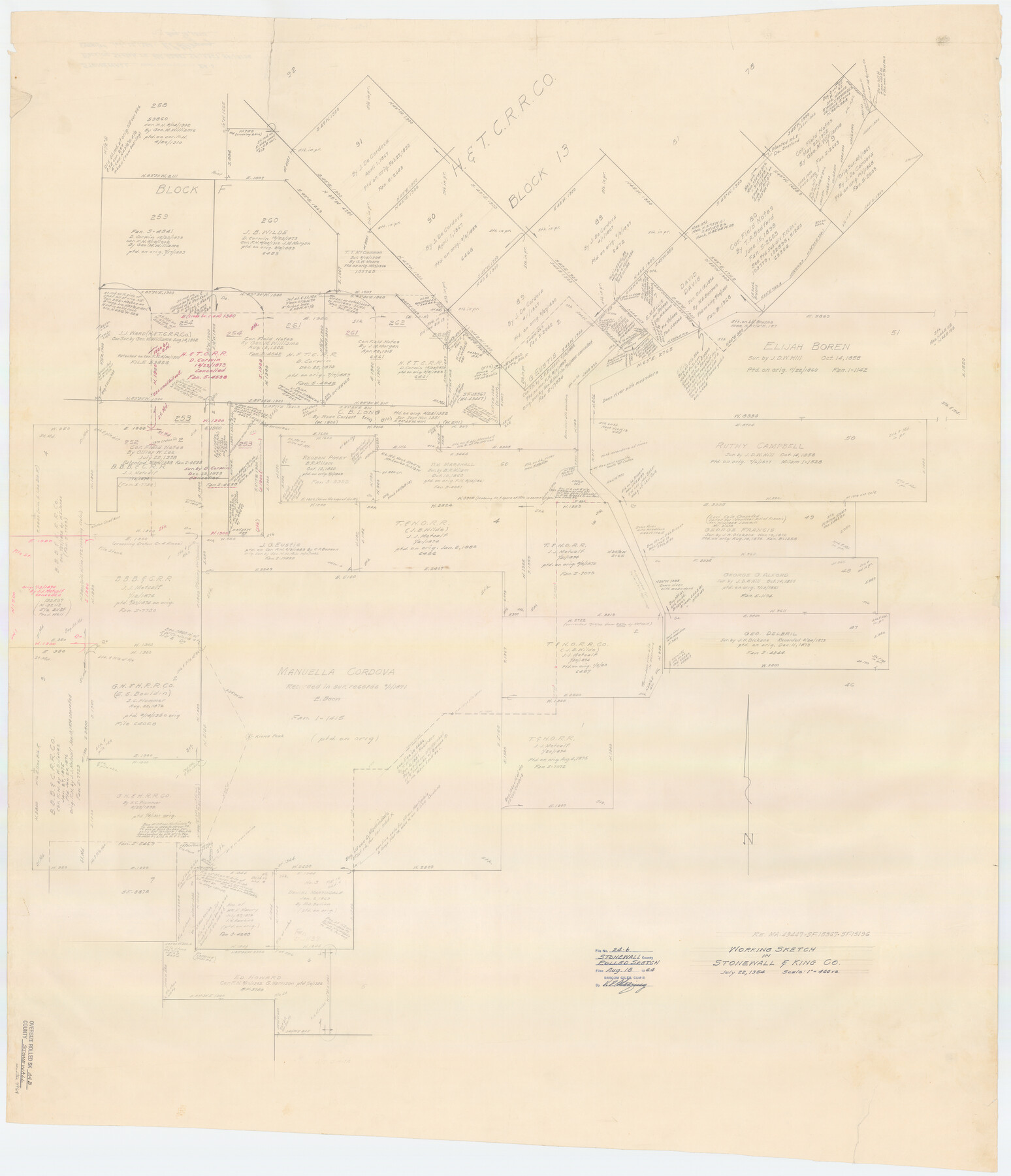
Stonewall County Rolled Sketch 24B
Working sketch of surveys in Stonewall and King Counties
-
Map/Doc
9964
-
Collection
General Map Collection
-
Object Dates
1954/7/22 (Creation Date)
1954/8/18 (File Date)
-
People and Organizations
Victor E. Sterzing (Draftsman)
-
Counties
Stonewall King
-
Subjects
Surveying Rolled Sketch
-
Height x Width
50.1 x 43.1 inches
127.3 x 109.5 cm
-
Medium
paper, manuscript
-
Scale
1" = 400 varas
-
Comments
See MA-43447, SF-15367, and SF-15196.
Part of: General Map Collection
Flight Mission No. DCL-7C, Frame 147, Kenedy County

Print $20.00
- Digital $50.00
Flight Mission No. DCL-7C, Frame 147, Kenedy County
1943
Size 18.3 x 22.4 inches
Map/Doc 86104
Midland County

Print $20.00
- Digital $50.00
Midland County
1930
Size 44.9 x 38.5 inches
Map/Doc 73239
Freestone County Working Sketch 16

Print $20.00
- Digital $50.00
Freestone County Working Sketch 16
1980
Size 47.1 x 39.7 inches
Map/Doc 69258
Guadalupe County Sketch File 16

Print $22.00
- Digital $50.00
Guadalupe County Sketch File 16
Size 15.7 x 12.4 inches
Map/Doc 24694
Val Verde County Working Sketch 92

Print $20.00
- Digital $50.00
Val Verde County Working Sketch 92
1978
Size 30.3 x 35.3 inches
Map/Doc 72227
Presidio County Sketch File 79

Print $20.00
- Digital $50.00
Presidio County Sketch File 79
1949
Size 17.0 x 30.8 inches
Map/Doc 11722
Limestone County Sketch File 28

Print $54.00
- Digital $50.00
Limestone County Sketch File 28
1986
Size 11.2 x 8.5 inches
Map/Doc 30216
Stephens County Working Sketch Graphic Index

Print $20.00
- Digital $50.00
Stephens County Working Sketch Graphic Index
1940
Size 41.1 x 39.4 inches
Map/Doc 76702
Taylor County

Print $20.00
- Digital $50.00
Taylor County
1934
Size 42.0 x 36.6 inches
Map/Doc 77432
Terrell County Working Sketch 61

Print $20.00
- Digital $50.00
Terrell County Working Sketch 61
1962
Size 20.3 x 34.3 inches
Map/Doc 69582
Crosby County Sketch File 1

Print $4.00
- Digital $50.00
Crosby County Sketch File 1
Size 12.8 x 8.1 inches
Map/Doc 19985
Nueces County Aerial Photograph Index Sheet 22

Print $20.00
- Digital $50.00
Nueces County Aerial Photograph Index Sheet 22
1938
Size 24.5 x 20.3 inches
Map/Doc 86843
You may also like
Map of Jack County

Print $20.00
- Digital $50.00
Map of Jack County
1896
Size 43.6 x 38.9 inches
Map/Doc 66877
Flight Mission No. DIX-10P, Frame 70, Aransas County

Print $20.00
- Digital $50.00
Flight Mission No. DIX-10P, Frame 70, Aransas County
1956
Size 18.7 x 22.4 inches
Map/Doc 83931
Crockett County Working Sketch 73

Print $20.00
- Digital $50.00
Crockett County Working Sketch 73
1963
Size 38.8 x 33.8 inches
Map/Doc 68406
El Paso County Working Sketch 34

Print $40.00
- Digital $50.00
El Paso County Working Sketch 34
1974
Size 53.4 x 34.7 inches
Map/Doc 69056
Hays County Working Sketch 8

Print $20.00
- Digital $50.00
Hays County Working Sketch 8
1942
Size 27.1 x 30.9 inches
Map/Doc 66082
Montgomery County Rolled Sketch 17

Print $20.00
- Digital $50.00
Montgomery County Rolled Sketch 17
1932
Size 26.6 x 34.9 inches
Map/Doc 6805
Flight Mission No. CUG-1P, Frame 78, Kleberg County

Print $20.00
- Digital $50.00
Flight Mission No. CUG-1P, Frame 78, Kleberg County
1956
Size 18.9 x 22.5 inches
Map/Doc 86143
Coke County Rolled Sketch 31

Print $20.00
- Digital $50.00
Coke County Rolled Sketch 31
1982
Size 13.3 x 30.2 inches
Map/Doc 5526
Interpretative map of wind erodibility. Gaines County, Texas

Interpretative map of wind erodibility. Gaines County, Texas
1986
Size 27.6 x 36.2 inches
Map/Doc 93561
Flight Mission No. DAG-19K, Frame 56, Matagorda County

Print $20.00
- Digital $50.00
Flight Mission No. DAG-19K, Frame 56, Matagorda County
1952
Size 18.5 x 22.3 inches
Map/Doc 86383

Comanche County Working Sketch 27

Print $40.00
- Digital $50.00
Comanche County Working Sketch 27
1983
Size 50.2 x 43.5 inches
Map/Doc 68161