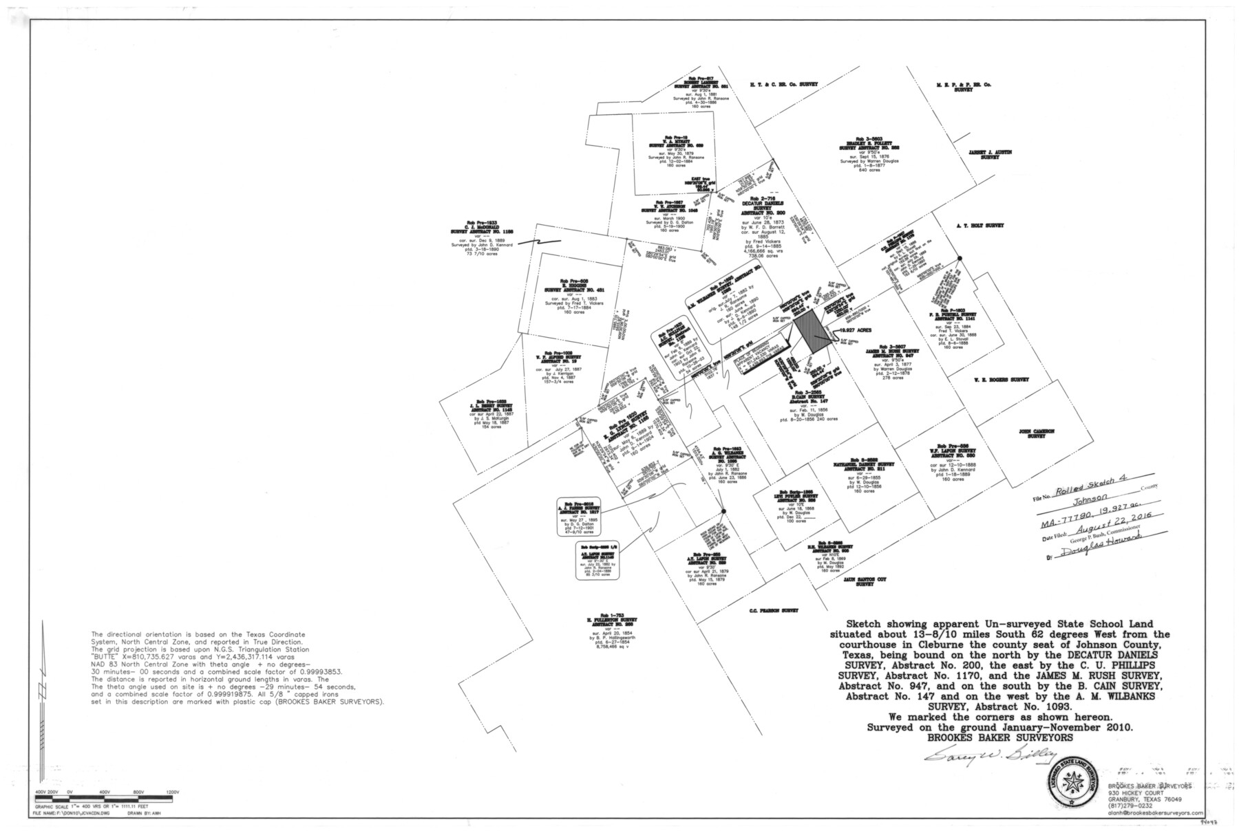
Johnson County Rolled Sketch 4
Sketch showing apparent un-surveyed State School Land situated about 13 8/10 miles South 62 degrees West from the courthouse in Cleburne the county seat of Johnson County, Texas
- 
                          Map/Doc94047
- 
                            CollectionGeneral Map Collection
- 
                            People and OrganizationsGarey W. Gilley (Surveyor/Engineer)
- 
                            CountiesJohnson
- 
                            SubjectsSurveying Rolled Sketch
- 
                            Height x Width24.8 x 36.0 inches63.0 x 91.4 cm
- 
                            Mediummylar, print
- 
                            Scale1" = 400 varas
Part of: General Map Collection
            Hardin County Sketch File 24a


                                            Print $8.00                    
                                             -                         Digital $50.00                                    
                Hardin County Sketch File 24a
1868
Size 5.8 x 7.9 inches
                                Map/Doc 25142
            
            Sutton County Working Sketch 8


                                            Print $20.00                    
                                             -                         Digital $50.00                                    
                Sutton County Working Sketch 8
Size 14.2 x 21.6 inches
                                Map/Doc 62351
            
            Irion County Sketch File 13


                                            Print $4.00                    
                                             -                         Digital $50.00                                    
                Irion County Sketch File 13
1940
Size 11.2 x 8.8 inches
                                Map/Doc 27484
            
            Robertson Co.


                                            Print $20.00                    
                                             -                         Digital $50.00                                    
                Robertson Co.
1945
Size 47.9 x 39.0 inches
                                Map/Doc 63004
            
            Lamb County Sketch File 9


                                            Print $4.00                    
                                             -                         Digital $50.00                                    
                Lamb County Sketch File 9
1910
Size 10.9 x 7.2 inches
                                Map/Doc 29358
            
            King County Working Sketch 17


                                            Print $40.00                    
                                             -                         Digital $50.00                                    
                King County Working Sketch 17
1979
Size 32.2 x 59.3 inches
                                Map/Doc 70181
            
            Stonewall County Working Sketch 34


                                            Print $20.00                    
                                             -                         Digital $50.00                                    
                Stonewall County Working Sketch 34
1985
Size 34.0 x 33.9 inches
                                Map/Doc 62341
            
            Runnels County Sketch File 18


                                            Print $10.00                    
                                    
                Runnels County Sketch File 18
1892
Size 14.0 x 8.4 inches
                                Map/Doc 35476
            
            [Surveys in Austin's Colony along New Year's Creek and the Navidad River]
            
                                    ![212, [Surveys in Austin's Colony along New Year's Creek and the Navidad River], General Map Collection](https://historictexasmaps.com/wmedia_w700/maps/212.tif.jpg) 


    ![212, [Surveys in Austin's Colony along New Year's Creek and the Navidad River], General Map Collection](https://historictexasmaps.com/wmedia_w700/maps/212.tif.jpg) 
                                
            
                                            Print $20.00                    
                                             -                         Digital $50.00                                    
                [Surveys in Austin's Colony along New Year's Creek and the Navidad River]
Size 20.2 x 15.6 inches
                                Map/Doc 212
            
            Anderson County Sketch File 26


                                            Print $40.00                    
                                             -                         Digital $50.00                                    
                Anderson County Sketch File 26
1954
Size 22.7 x 17.4 inches
                                Map/Doc 10805
            
            Houston County Sketch File 4a


                                            Print $4.00                    
                                             -                         Digital $50.00                                    
                Houston County Sketch File 4a
1858
Size 13.0 x 8.3 inches
                                Map/Doc 26754
            You may also like
            Flight Mission No. BRA-16M, Frame 64, Jefferson County


                                            Print $20.00                    
                                             -                         Digital $50.00                                    
                Flight Mission No. BRA-16M, Frame 64, Jefferson County
1953
Size 18.8 x 22.3 inches
                                Map/Doc 85681
            
            [John H. Gibson Section 892 and Surrounding Surveys]
            
                                    ![92841, [John H. Gibson Section 892 and Surrounding Surveys], Twichell Survey Records](https://historictexasmaps.com/wmedia_w700/maps/92841-1.tif.jpg) 


    ![92841, [John H. Gibson Section 892 and Surrounding Surveys], Twichell Survey Records](https://historictexasmaps.com/wmedia_w700/maps/92841-1.tif.jpg) 
                                
            
                                            Print $3.00                    
                                             -                         Digital $50.00                                    
                [John H. Gibson Section 892 and Surrounding Surveys]
Size 15.7 x 11.7 inches
                                Map/Doc 92841
            
            Dawson County Sketch File 26


                                            Print $10.00                    
                                             -                         Digital $50.00                                    
                Dawson County Sketch File 26
Size 14.7 x 9.1 inches
                                Map/Doc 20583
            
            McCulloch County Working Sketch 10


                                            Print $4.00                    
                                             -                         Digital $50.00                                    
                McCulloch County Working Sketch 10
1979
Size 19.1 x 21.2 inches
                                Map/Doc 70685
            
            Culberson County Sketch File 10a


                                            Print $20.00                    
                                             -                         Digital $50.00                                    
                Culberson County Sketch File 10a
1926
Size 11.9 x 18.3 inches
                                Map/Doc 11264
            
            Whiteface Cemetery


                                            Print $20.00                    
                                             -                         Digital $50.00                                    
                Whiteface Cemetery
Size 29.3 x 18.0 inches
                                Map/Doc 92525
            
            Haskell County Rolled Sketch 10


                                            Print $20.00                    
                                             -                         Digital $50.00                                    
                Haskell County Rolled Sketch 10
1981
Size 33.2 x 14.3 inches
                                Map/Doc 6169
            
            Flight Mission No. CZW-2R, Frame 27, Hardeman County


                                            Print $20.00                    
                                             -                         Digital $50.00                                    
                Flight Mission No. CZW-2R, Frame 27, Hardeman County
1956
Size 18.8 x 22.4 inches
                                Map/Doc 85238
            
            Gonzales County Working Sketch 14


                                            Print $20.00                    
                                             -                         Digital $50.00                                    
                Gonzales County Working Sketch 14
1981
Size 18.3 x 20.9 inches
                                Map/Doc 63230
            
            Brazoria County


                                            Print $20.00                    
                                             -                         Digital $50.00                                    
                Brazoria County
1879
Size 27.0 x 25.1 inches
                                Map/Doc 4647
            
            Jackson County Working Sketch Graphic Index


                                            Print $20.00                    
                                             -                         Digital $50.00                                    
                Jackson County Working Sketch Graphic Index
1920
Size 47.0 x 40.3 inches
                                Map/Doc 76590
            
            La Salle County Working Sketch 19


                                            Print $20.00                    
                                             -                         Digital $50.00                                    
                La Salle County Working Sketch 19
1941
Size 24.6 x 31.4 inches
                                Map/Doc 70320
             
                        