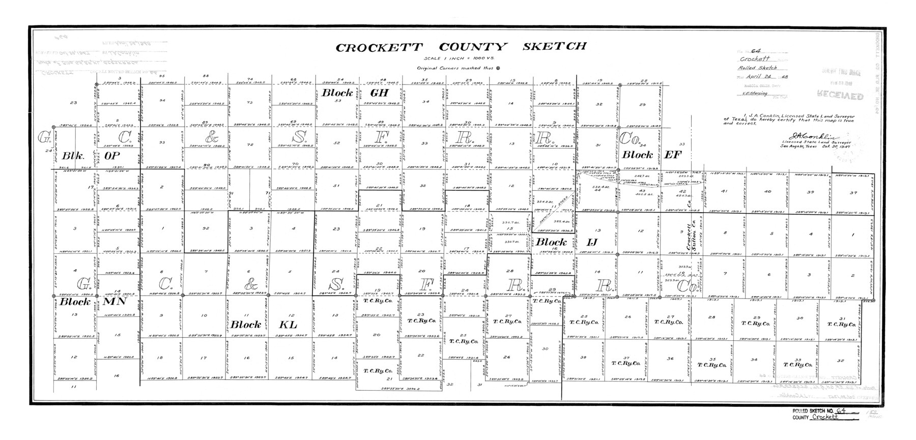
Crockett County Rolled Sketch 64
Crockett County Sketch
-
Map/Doc
5607
-
Collection
General Map Collection
-
Object Dates
1947/10/30 (Creation Date)
1948/4/24 (File Date)
-
People and Organizations
J.A. Conklin (Surveyor/Engineer)
-
Counties
Crockett Sutton
-
Subjects
Surveying Rolled Sketch
-
Height x Width
19.8 x 41.2 inches
50.3 x 104.6 cm
-
Scale
1" = 1000 varas
Part of: General Map Collection
Cottle County

Print $20.00
- Digital $50.00
Cottle County
1971
Size 42.5 x 35.7 inches
Map/Doc 73118
Grayson County Working Sketch 21

Print $20.00
- Digital $50.00
Grayson County Working Sketch 21
1961
Size 42.6 x 26.5 inches
Map/Doc 63260

Zavala County Boundary File 2

Print $36.00
- Digital $50.00
Zavala County Boundary File 2
Size 9.2 x 4.3 inches
Map/Doc 60239
Orange County Working Sketch 31

Print $20.00
- Digital $50.00
Orange County Working Sketch 31
1955
Size 24.2 x 13.8 inches
Map/Doc 71363
Presidio County Sketch File 58

Print $40.00
- Digital $50.00
Presidio County Sketch File 58
1933
Size 14.7 x 14.4 inches
Map/Doc 34635
Montague County Working Sketch 42

Print $20.00
- Digital $50.00
Montague County Working Sketch 42
2009
Size 19.9 x 25.4 inches
Map/Doc 89004
Chambers County Sketch File 35

Print $14.00
- Digital $50.00
Chambers County Sketch File 35
Size 7.1 x 7.6 inches
Map/Doc 17625
Flight Mission No. CRC-5R, Frame 37, Chambers County

Print $20.00
- Digital $50.00
Flight Mission No. CRC-5R, Frame 37, Chambers County
1956
Size 18.6 x 22.4 inches
Map/Doc 84956
Childress County Working Sketch 3

Print $20.00
- Digital $50.00
Childress County Working Sketch 3
1927
Size 22.4 x 18.6 inches
Map/Doc 68019
Eastland County Working Sketch 66

Print $20.00
- Digital $50.00
Eastland County Working Sketch 66
2014
Size 27.2 x 20.1 inches
Map/Doc 93708
Flight Mission No. DCL-6C, Frame 2, Kenedy County

Print $20.00
- Digital $50.00
Flight Mission No. DCL-6C, Frame 2, Kenedy County
1943
Size 18.6 x 22.4 inches
Map/Doc 85862
You may also like
Sutton County Sketch File H

Print $22.00
- Digital $50.00
Sutton County Sketch File H
Size 14.3 x 8.7 inches
Map/Doc 37400
Erath County Sketch File A2

Print $20.00
- Digital $50.00
Erath County Sketch File A2
Size 15.9 x 19.5 inches
Map/Doc 11464
Atascosa County Sketch File 14

Print $40.00
- Digital $50.00
Atascosa County Sketch File 14
1870
Size 12.5 x 15.0 inches
Map/Doc 13773

Robertson County Working Sketch 18

Print $20.00
- Digital $50.00
Robertson County Working Sketch 18
1995
Size 29.9 x 34.1 inches
Map/Doc 63591
Midland County Rolled Sketch 5

Print $20.00
- Digital $50.00
Midland County Rolled Sketch 5
Size 35.3 x 44.8 inches
Map/Doc 10695
[Plat of the Town of Lockhart]
![82534, [Plat of the Town of Lockhart], General Map Collection](https://historictexasmaps.com/wmedia_w700/maps/82534-1.tif.jpg)
Print $20.00
- Digital $50.00
[Plat of the Town of Lockhart]
Size 19.5 x 25.0 inches
Map/Doc 82534
Waller County Sketch File 3

Print $4.00
- Digital $50.00
Waller County Sketch File 3
Size 13.0 x 8.4 inches
Map/Doc 39598
Sutton County Working Sketch 16

Print $40.00
- Digital $50.00
Sutton County Working Sketch 16
1972
Size 30.9 x 67.6 inches
Map/Doc 62359
Presidio County Working Sketch 35

Print $20.00
- Digital $50.00
Presidio County Working Sketch 35
1947
Size 25.7 x 47.3 inches
Map/Doc 71712
Victoria County, Texas

Print $20.00
- Digital $50.00
Victoria County, Texas
1879
Size 26.5 x 22.8 inches
Map/Doc 511
Titus County Sketch File 12

Print $40.00
- Digital $50.00
Titus County Sketch File 12
1891
Size 14.9 x 14.2 inches
Map/Doc 38152