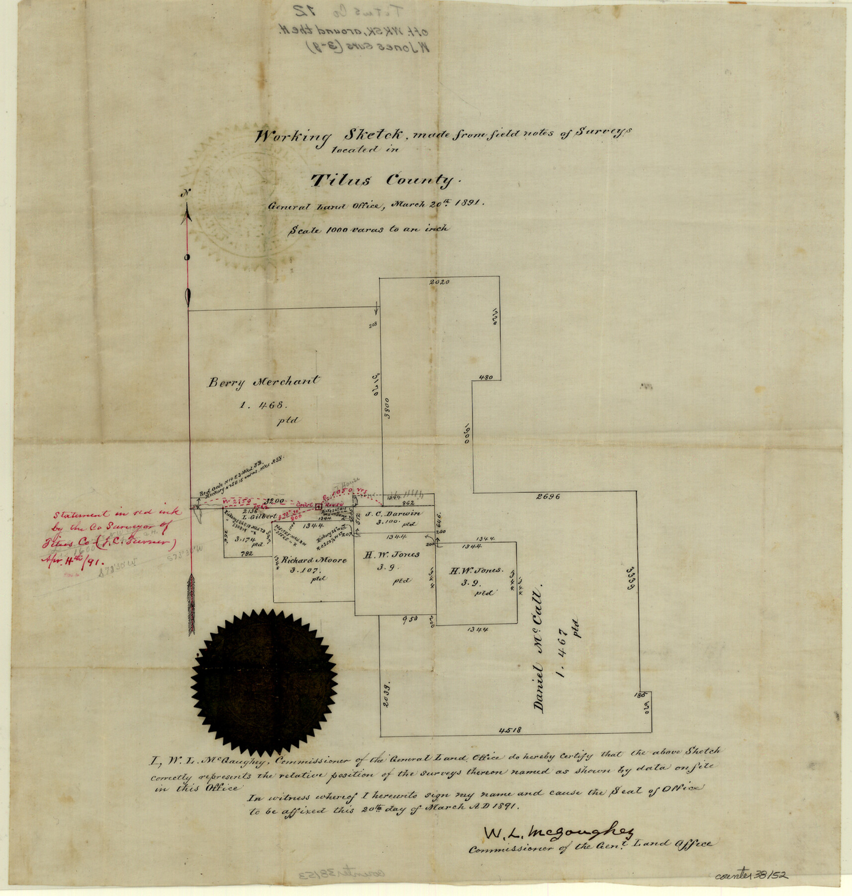
Titus County Sketch File 12
[Office working sketch of area around the county seat, Mount Pleasant]
-
Map/Doc
38152
-
Collection
General Map Collection
-
Object Dates
3/20/1891 (Creation Date)
-
People and Organizations
J.C. Turner (Surveyor/Engineer)
W.L. McGoughey (GLO Commissioner)
-
Counties
Titus
-
Subjects
Surveying Sketch File
-
Height x Width
14.9 x 14.2 inches
37.9 x 36.1 cm
-
Medium
paper, manuscript
-
Scale
1" = 1000 varas
Part of: General Map Collection
Flight Mission No. DAG-24K, Frame 155, Matagorda County

Print $20.00
- Digital $50.00
Flight Mission No. DAG-24K, Frame 155, Matagorda County
1953
Size 15.9 x 15.8 inches
Map/Doc 86569
Wilson County Rolled Sketch 3

Print $20.00
- Digital $50.00
Wilson County Rolled Sketch 3
1956
Size 25.8 x 22.8 inches
Map/Doc 8369
Bosque County Working Sketch 5

Print $20.00
- Digital $50.00
Bosque County Working Sketch 5
1935
Size 20.5 x 28.9 inches
Map/Doc 67438
Young County Working Sketch 24

Print $20.00
- Digital $50.00
Young County Working Sketch 24
1977
Size 25.7 x 16.3 inches
Map/Doc 62047
Angelina County Sketch File 31

Print $8.00
- Digital $50.00
Angelina County Sketch File 31
1988
Size 11.2 x 8.8 inches
Map/Doc 13089
Kimble County Working Sketch 92

Print $20.00
- Digital $50.00
Kimble County Working Sketch 92
1979
Size 24.0 x 30.6 inches
Map/Doc 70160
Crockett County Sketch File 61

Print $20.00
- Digital $50.00
Crockett County Sketch File 61
1926
Size 22.0 x 26.0 inches
Map/Doc 11228
Flight Mission No. DIX-6P, Frame 201, Aransas County

Print $20.00
- Digital $50.00
Flight Mission No. DIX-6P, Frame 201, Aransas County
1956
Size 18.9 x 22.8 inches
Map/Doc 83863
Flight Mission No. CLL-1N, Frame 21, Willacy County

Print $20.00
- Digital $50.00
Flight Mission No. CLL-1N, Frame 21, Willacy County
1954
Size 18.7 x 22.3 inches
Map/Doc 87008
Duval County Working Sketch 50

Print $20.00
- Digital $50.00
Duval County Working Sketch 50
1984
Size 38.0 x 32.0 inches
Map/Doc 68774
Upton County Working Sketch 33

Print $20.00
- Digital $50.00
Upton County Working Sketch 33
1955
Size 17.9 x 37.8 inches
Map/Doc 69529
Andrews County Boundary File 3

Print $8.00
- Digital $50.00
Andrews County Boundary File 3
Size 7.2 x 8.6 inches
Map/Doc 49717
You may also like
Map of Castro's Colony - Bexar District

Print $20.00
- Digital $50.00
Map of Castro's Colony - Bexar District
1851
Size 36.4 x 33.1 inches
Map/Doc 1962
Flight Mission No. DIX-6P, Frame 111, Aransas County

Print $20.00
- Digital $50.00
Flight Mission No. DIX-6P, Frame 111, Aransas County
1956
Size 18.9 x 22.6 inches
Map/Doc 83817

[St. Louis & Southwestern]
![64280, [St. Louis & Southwestern], General Map Collection](https://historictexasmaps.com/wmedia_w700/maps/64280.tif.jpg)
Print $20.00
- Digital $50.00
[St. Louis & Southwestern]
Size 20.3 x 27.9 inches
Map/Doc 64280
Revised Sectional Map Number 2, Showing Surveys in Howard, Martin, Andrews, Glasscock, Midland, Ector

Print $20.00
- Digital $50.00
Revised Sectional Map Number 2, Showing Surveys in Howard, Martin, Andrews, Glasscock, Midland, Ector
1908
Size 24.7 x 19.6 inches
Map/Doc 91367
Tom Green County Rolled Sketch 1

Print $20.00
- Digital $50.00
Tom Green County Rolled Sketch 1
Size 29.8 x 25.4 inches
Map/Doc 7991
Dawson County Working Sketch 16

Print $20.00
- Digital $50.00
Dawson County Working Sketch 16
1956
Size 13.9 x 18.8 inches
Map/Doc 68560
San Patricio County Working Sketch 3

Print $20.00
- Digital $50.00
San Patricio County Working Sketch 3
1917
Size 22.2 x 42.7 inches
Map/Doc 63765
Dimmit County Working Sketch 12

Print $20.00
- Digital $50.00
Dimmit County Working Sketch 12
1941
Size 14.4 x 16.3 inches
Map/Doc 68673
Bandera County Working Sketch 12

Print $20.00
- Digital $50.00
Bandera County Working Sketch 12
Size 34.0 x 36.9 inches
Map/Doc 67605
Flight Mission No. CLL-1N, Frame 78, Willacy County

Print $20.00
- Digital $50.00
Flight Mission No. CLL-1N, Frame 78, Willacy County
1954
Size 18.4 x 22.1 inches
Map/Doc 87024
Map of the Missouri, Kansas and Texas Railway and connecting lines

Print $20.00
- Digital $50.00
Map of the Missouri, Kansas and Texas Railway and connecting lines
1889
Size 17.7 x 32.1 inches
Map/Doc 95806