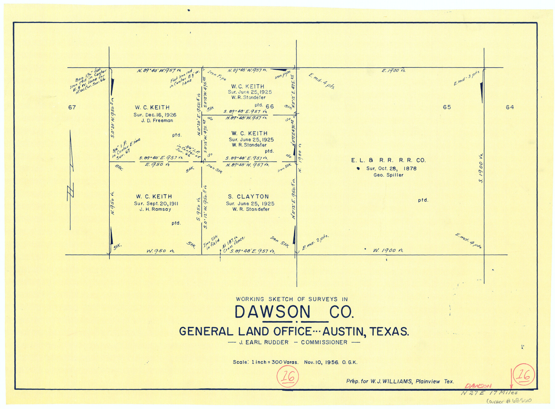
Dawson County Working Sketch 16
-
Map/Doc
68560
-
Collection
General Map Collection
-
Counties
Dawson
-
Subjects
Cadastral Surveying Working Sketch
-
Height x Width
13.9 x 18.8 inches
35.3 x 47.8 cm
Part of: General Map Collection
Wood County Boundary File 6
![60180, Wood County Boundary File 6, General Map Collection](https://historictexasmaps.com/wmedia_w700/pdf_converted_jpg/qi_pdf_thumbnail_16971.jpg)
Print $32.00
- Digital $50.00
Wood County Boundary File 6
Size 14.3 x 8.6 inches
Map/Doc 60180
Brooks County Boundary File Index
![50808, Brooks County Boundary File Index, General Map Collection](https://historictexasmaps.com/wmedia_w700/pdf_converted_jpg/qi_pdf_thumbnail_15689.jpg)
Print $2.00
- Digital $50.00
Brooks County Boundary File Index
Size 8.6 x 3.1 inches
Map/Doc 50808
Harris County Sketch File C
![25311, Harris County Sketch File C, General Map Collection](https://historictexasmaps.com/wmedia_w700/pdf_converted_jpg/qi_pdf_thumbnail_11698.jpg)
Print $4.00
- Digital $50.00
Harris County Sketch File C
1866
Size 5.9 x 9.8 inches
Map/Doc 25311
Bowie County Sketch File 6
![14839, Bowie County Sketch File 6, General Map Collection](https://historictexasmaps.com/wmedia_w700/pdf_converted_jpg/qi_pdf_thumbnail_9512.jpg)
Print $10.00
- Digital $50.00
Bowie County Sketch File 6
1927
Size 8.5 x 4.0 inches
Map/Doc 14839
Maps of Gulf Intracoastal Waterway, Texas - Sabine River to the Rio Grande and connecting waterways including ship channels
![61982, Maps of Gulf Intracoastal Waterway, Texas - Sabine River to the Rio Grande and connecting waterways including ship channels, General Map Collection](https://historictexasmaps.com/wmedia_w700/maps/61982.tif.jpg)
Print $20.00
- Digital $50.00
Maps of Gulf Intracoastal Waterway, Texas - Sabine River to the Rio Grande and connecting waterways including ship channels
1966
Size 14.6 x 21.6 inches
Map/Doc 61982
Chambers County Boundary File 4
![51259, Chambers County Boundary File 4, General Map Collection](https://historictexasmaps.com/wmedia_w700/pdf_converted_jpg/qi_pdf_thumbnail_15741.jpg)
Print $34.00
- Digital $50.00
Chambers County Boundary File 4
1909
Size 9.1 x 3.9 inches
Map/Doc 51259
Kendall County Sketch File 2
![28682, Kendall County Sketch File 2, General Map Collection](https://historictexasmaps.com/wmedia_w700/pdf_converted_jpg/qi_pdf_thumbnail_12387.jpg)
Print $6.00
- Digital $50.00
Kendall County Sketch File 2
1847
Size 14.6 x 10.9 inches
Map/Doc 28682
Carson County Boundary File 5c
![51146, Carson County Boundary File 5c, General Map Collection](https://historictexasmaps.com/wmedia_w700/pdf_converted_jpg/qi_pdf_thumbnail_15728.jpg)
Print $10.00
- Digital $50.00
Carson County Boundary File 5c
Size 14.2 x 8.7 inches
Map/Doc 51146
Runnels County Rolled Sketch 41
![7529, Runnels County Rolled Sketch 41, General Map Collection](https://historictexasmaps.com/wmedia_w700/maps/7529.tif.jpg)
Print $20.00
- Digital $50.00
Runnels County Rolled Sketch 41
Size 26.1 x 29.8 inches
Map/Doc 7529
Cottle County Sketch File AA1
![19398, Cottle County Sketch File AA1, General Map Collection](https://historictexasmaps.com/wmedia_w700/pdf_converted_jpg/qi_pdf_thumbnail_10418.jpg)
Print $95.00
- Digital $50.00
Cottle County Sketch File AA1
1895
Size 9.4 x 4.2 inches
Map/Doc 19398
Crosby County Sketch File 19
![20084, Crosby County Sketch File 19, General Map Collection](https://historictexasmaps.com/wmedia_w700/pdf_converted_jpg/qi_pdf_thumbnail_10546.jpg)
Print $6.00
- Digital $50.00
Crosby County Sketch File 19
1910
Size 8.2 x 8.1 inches
Map/Doc 20084
Right of Way and Track Map, the Missouri, Kansas and Texas Ry. of Texas - Henrietta Division
![64756, Right of Way and Track Map, the Missouri, Kansas and Texas Ry. of Texas - Henrietta Division, General Map Collection](https://historictexasmaps.com/wmedia_w700/maps/64756.tif.jpg)
Print $20.00
- Digital $50.00
Right of Way and Track Map, the Missouri, Kansas and Texas Ry. of Texas - Henrietta Division
1918
Size 11.7 x 26.8 inches
Map/Doc 64756
You may also like
Colorado County Rolled Sketch 5
![8644, Colorado County Rolled Sketch 5, General Map Collection](https://historictexasmaps.com/wmedia_w700/maps/8644.tif.jpg)
Print $20.00
- Digital $50.00
Colorado County Rolled Sketch 5
1965
Size 37.9 x 35.9 inches
Map/Doc 8644
[T. & N. O. RR. Block 1T]
![91902, [T. & N. O. RR. Block 1T], Twichell Survey Records](https://historictexasmaps.com/wmedia_w700/maps/91902-1.tif.jpg)
Print $20.00
- Digital $50.00
[T. & N. O. RR. Block 1T]
Size 14.9 x 20.0 inches
Map/Doc 91902
Sterling County Rolled Sketch 10
![7846, Sterling County Rolled Sketch 10, General Map Collection](https://historictexasmaps.com/wmedia_w700/maps/7846.tif.jpg)
Print $20.00
- Digital $50.00
Sterling County Rolled Sketch 10
1939
Size 24.2 x 31.2 inches
Map/Doc 7846
Hood County Sketch File 7
![26581, Hood County Sketch File 7, General Map Collection](https://historictexasmaps.com/wmedia_w700/pdf_converted_jpg/qi_pdf_thumbnail_11928.jpg)
Print $6.00
- Digital $50.00
Hood County Sketch File 7
Size 12.9 x 7.9 inches
Map/Doc 26581
[Texas & Pacific RR. Co. Blocks 6 and 4, L. C. Denison, Guadalupe College and vicinity]
![92133, [Texas & Pacific RR. Co. Blocks 6 and 4, L. C. Denison, Guadalupe College and vicinity], Twichell Survey Records](https://historictexasmaps.com/wmedia_w700/maps/92133-1.tif.jpg)
Print $20.00
- Digital $50.00
[Texas & Pacific RR. Co. Blocks 6 and 4, L. C. Denison, Guadalupe College and vicinity]
Size 32.5 x 19.8 inches
Map/Doc 92133
Reeves County Working Sketch 18
![63461, Reeves County Working Sketch 18, General Map Collection](https://historictexasmaps.com/wmedia_w700/maps/63461.tif.jpg)
Print $20.00
- Digital $50.00
Reeves County Working Sketch 18
Size 24.7 x 40.2 inches
Map/Doc 63461
Flight Mission No. BRA-7M, Frame 15, Jefferson County
![85466, Flight Mission No. BRA-7M, Frame 15, Jefferson County, General Map Collection](https://historictexasmaps.com/wmedia_w700/pdf_converted_jpg/qi_pdf_thumbnail_32666.jpg)
Print $20.00
- Digital $50.00
Flight Mission No. BRA-7M, Frame 15, Jefferson County
1953
Size 18.6 x 22.3 inches
Map/Doc 85466
Red River County Working Sketch 39
![72022, Red River County Working Sketch 39, General Map Collection](https://historictexasmaps.com/wmedia_w700/maps/72022.tif.jpg)
Print $6.00
- Digital $50.00
Red River County Working Sketch 39
Size 33.4 x 23.8 inches
Map/Doc 72022
Flight Mission No. DCL-5C, Frame 69, Kenedy County
![85852, Flight Mission No. DCL-5C, Frame 69, Kenedy County, General Map Collection](https://historictexasmaps.com/wmedia_w700/pdf_converted_jpg/qi_pdf_thumbnail_33042.jpg)
Print $20.00
- Digital $50.00
Flight Mission No. DCL-5C, Frame 69, Kenedy County
1943
Size 18.5 x 22.3 inches
Map/Doc 85852
[Showing west and north line of County]
![90652, [Showing west and north line of County], Twichell Survey Records](https://historictexasmaps.com/wmedia_w700/maps/90652-1.tif.jpg)
Print $20.00
- Digital $50.00
[Showing west and north line of County]
1885
Size 21.3 x 29.0 inches
Map/Doc 90652
Grayson County Sketch File 9
![24472, Grayson County Sketch File 9, General Map Collection](https://historictexasmaps.com/wmedia_w700/pdf_converted_jpg/qi_pdf_thumbnail_11461.jpg)
Print $4.00
- Digital $50.00
Grayson County Sketch File 9
1857
Size 12.1 x 8.1 inches
Map/Doc 24472
Intracoastal Waterway in Texas - Corpus Christi to Point Isabel including Arroyo Colorado to Mo. Pac. R.R. Bridge Near Harlingen
![61860, Intracoastal Waterway in Texas - Corpus Christi to Point Isabel including Arroyo Colorado to Mo. Pac. R.R. Bridge Near Harlingen, General Map Collection](https://historictexasmaps.com/wmedia_w700/maps/61860.tif.jpg)
Print $20.00
- Digital $50.00
Intracoastal Waterway in Texas - Corpus Christi to Point Isabel including Arroyo Colorado to Mo. Pac. R.R. Bridge Near Harlingen
1933
Size 28.0 x 41.0 inches
Map/Doc 61860