Midland County Rolled Sketch 5
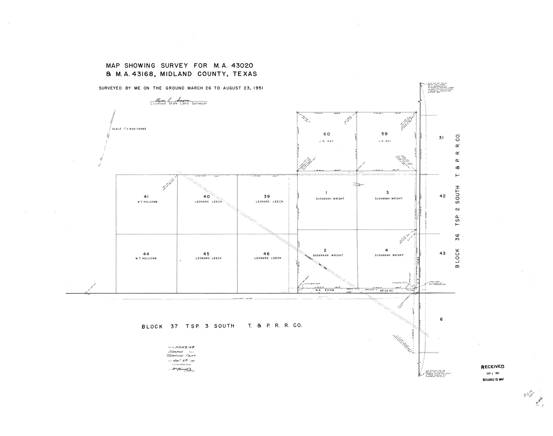
Map showing survey for MA-43020 & MA-43168, Midland County, Texas
-
Map/Doc
10695
-
Collection
General Map Collection
-
Object Dates
1951/8/23 (Survey Date)
1951/9/5 (File Date)
-
People and Organizations
Byron L. Simpson (Surveyor/Engineer)
-
Counties
Midland
-
Subjects
Surveying Rolled Sketch
-
Height x Width
35.3 x 44.8 inches
89.7 x 113.8 cm
-
Scale
1" = 400 varas
Part of: General Map Collection

Kinney County Rolled Sketch 20

Print $40.00
- Digital $50.00
Kinney County Rolled Sketch 20
1979
Size 37.8 x 59.7 inches
Map/Doc 9357
Kimble County Rolled Sketch 32

Print $20.00
- Digital $50.00
Kimble County Rolled Sketch 32
1973
Size 23.1 x 19.6 inches
Map/Doc 6522
Eastland County Working Sketch 24

Print $20.00
- Digital $50.00
Eastland County Working Sketch 24
1922
Size 36.1 x 27.1 inches
Map/Doc 68805
Cameron County Rolled Sketch 20D

Print $20.00
- Digital $50.00
Cameron County Rolled Sketch 20D
Size 14.3 x 13.9 inches
Map/Doc 5477
Hutchinson County Rolled Sketch 42

Print $40.00
- Digital $50.00
Hutchinson County Rolled Sketch 42
1993
Size 38.0 x 49.5 inches
Map/Doc 6310
Calhoun County Working Sketch 2a

Print $20.00
- Digital $50.00
Calhoun County Working Sketch 2a
1913
Size 17.4 x 20.1 inches
Map/Doc 67817
Garza County Rolled Sketch R1

Print $40.00
- Digital $50.00
Garza County Rolled Sketch R1
Size 32.1 x 49.3 inches
Map/Doc 9045
[Plat and field notes of 3.107 acre tract for Clement Cove Harbor Company]
![60397, [Plat and field notes of 3.107 acre tract for Clement Cove Harbor Company], General Map Collection](https://historictexasmaps.com/wmedia_w700/maps/60397-1.tif.jpg)
Print $20.00
- Digital $50.00
[Plat and field notes of 3.107 acre tract for Clement Cove Harbor Company]
1987
Size 24.2 x 36.5 inches
Map/Doc 60397
Chambers County NRC Article 33.136 Sketch 2

Print $2.00
- Digital $50.00
Chambers County NRC Article 33.136 Sketch 2
2004
Size 8.2 x 10.8 inches
Map/Doc 82998
Nueces County Rolled Sketch 39

Print $20.00
- Digital $50.00
Nueces County Rolled Sketch 39
1957
Size 32.9 x 45.3 inches
Map/Doc 6879
Hopkins County Sketch File 17

Print $6.00
- Digital $50.00
Hopkins County Sketch File 17
1870
Size 7.8 x 8.0 inches
Map/Doc 26720
You may also like
Hutchinson County Rolled Sketch 37

Print $20.00
- Digital $50.00
Hutchinson County Rolled Sketch 37
1950
Size 24.4 x 44.4 inches
Map/Doc 6296
Map of Hays County, Texas

Print $20.00
- Digital $50.00
Map of Hays County, Texas
1880
Size 28.9 x 23.6 inches
Map/Doc 401
Hood County Rolled Sketch 5

Print $20.00
- Digital $50.00
Hood County Rolled Sketch 5
1980
Size 29.9 x 32.2 inches
Map/Doc 6221
Map of Europe engraved to illustrate Mitchell's school and family geography

Print $20.00
- Digital $50.00
Map of Europe engraved to illustrate Mitchell's school and family geography
1839
Size 9.5 x 11.8 inches
Map/Doc 93502

Florida called by ye French Louisiana & c.

Print $20.00
- Digital $50.00
Florida called by ye French Louisiana & c.
1728
Size 9.6 x 14.3 inches
Map/Doc 94110
[John H. Tyler and Bob Reid Strip Surveys in Yates Field]
![91582, [John H. Tyler and Bob Reid Strip Surveys in Yates Field], Twichell Survey Records](https://historictexasmaps.com/wmedia_w700/maps/91582-1.tif.jpg)
Print $2.00
- Digital $50.00
[John H. Tyler and Bob Reid Strip Surveys in Yates Field]
Size 14.3 x 8.8 inches
Map/Doc 91582
Rusk County Rolled Sketch 4

Print $20.00
- Digital $50.00
Rusk County Rolled Sketch 4
1895
Size 47.8 x 33.9 inches
Map/Doc 9874
Tyler County Rolled Sketch 11

Print $20.00
- Digital $50.00
Tyler County Rolled Sketch 11
Size 34.2 x 36.4 inches
Map/Doc 10033
Red River County Working Sketch 81-4

Print $20.00
- Digital $50.00
Red River County Working Sketch 81-4
1987
Size 21.8 x 16.7 inches
Map/Doc 72067
Flight Mission No. CZW-2R, Frame 66, Hardeman County

Print $20.00
- Digital $50.00
Flight Mission No. CZW-2R, Frame 66, Hardeman County
1956
Size 18.6 x 22.4 inches
Map/Doc 85239
Hamilton County Boundary File 5

Print $35.00
- Digital $50.00
Hamilton County Boundary File 5
Size 11.1 x 8.6 inches
Map/Doc 54217