Garza County Rolled Sketch R1
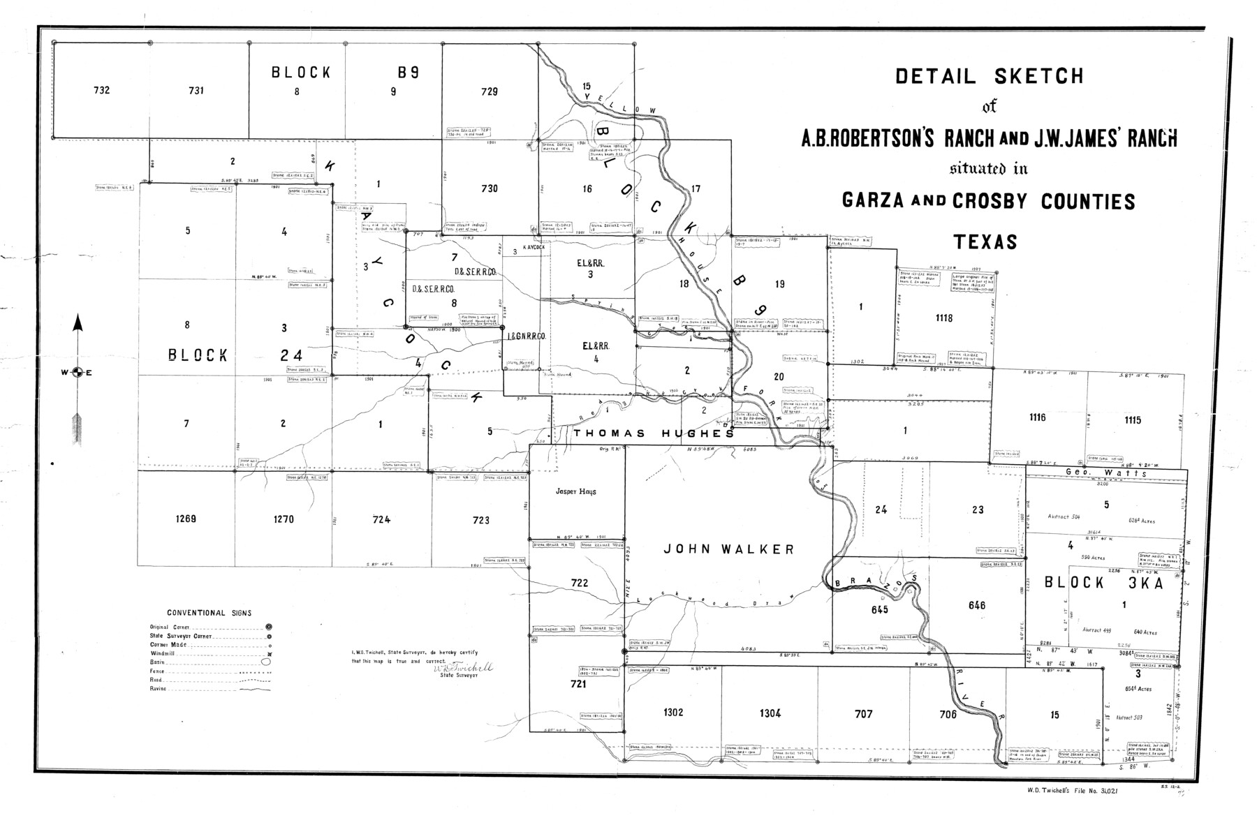
Detail sketch of A.B. Robertson's Ranch and J.W. James' Ranch situated in Garza and Crosby Counties, Texas
-
Map/Doc
9045
-
Collection
General Map Collection
-
People and Organizations
W.D. Twichell (Surveyor/Engineer)
-
Counties
Garza Crosby
-
Subjects
Surveying Rolled Sketch
-
Height x Width
32.1 x 49.3 inches
81.5 x 125.2 cm
Part of: General Map Collection
Flight Mission No. DAH-17M, Frame 30, Orange County

Print $20.00
- Digital $50.00
Flight Mission No. DAH-17M, Frame 30, Orange County
1953
Size 18.7 x 22.5 inches
Map/Doc 86893
Foard County Boundary File 5a

Print $40.00
- Digital $50.00
Foard County Boundary File 5a
Size 18.2 x 44.4 inches
Map/Doc 53546
Liberty County Rolled Sketch P

Print $33.00
- Digital $50.00
Liberty County Rolled Sketch P
Size 10.3 x 16.5 inches
Map/Doc 46545
Pecos County Sketch File 52

Print $10.00
- Digital $50.00
Pecos County Sketch File 52
Size 8.6 x 3.8 inches
Map/Doc 33781
Montague County Working Sketch 23

Print $20.00
- Digital $50.00
Montague County Working Sketch 23
1953
Size 31.2 x 27.5 inches
Map/Doc 71089
Real County Working Sketch 62

Print $20.00
- Digital $50.00
Real County Working Sketch 62
1966
Size 26.4 x 23.2 inches
Map/Doc 71954
Uvalde County Working Sketch 50

Print $40.00
- Digital $50.00
Uvalde County Working Sketch 50
1980
Size 55.7 x 36.6 inches
Map/Doc 72120
Travis County Boundary File 30

Print $4.00
- Digital $50.00
Travis County Boundary File 30
Size 10.4 x 8.6 inches
Map/Doc 59469
Map of Taylor, Bastrop & Houston Railroad in Williamson, Travis, & Bastrop Counties, Texas

Print $20.00
- Digital $50.00
Map of Taylor, Bastrop & Houston Railroad in Williamson, Travis, & Bastrop Counties, Texas
1887
Size 26.3 x 17.8 inches
Map/Doc 65468
Reeves County

Print $40.00
- Digital $50.00
Reeves County
1945
Size 49.4 x 40.8 inches
Map/Doc 95624
The Texas and Pacific Ry. Co., Station Map, Iatan, Mitchell County, Texas

Print $20.00
- Digital $50.00
The Texas and Pacific Ry. Co., Station Map, Iatan, Mitchell County, Texas
1929
Size 11.0 x 18.4 inches
Map/Doc 64667
Map of Erath County

Print $40.00
- Digital $50.00
Map of Erath County
1896
Size 50.4 x 45.1 inches
Map/Doc 7820
You may also like
Flight Mission No. DCL-7C, Frame 149, Kenedy County

Print $20.00
- Digital $50.00
Flight Mission No. DCL-7C, Frame 149, Kenedy County
1943
Size 18.7 x 22.5 inches
Map/Doc 86106
Working Sketch Armstrong County

Print $20.00
- Digital $50.00
Working Sketch Armstrong County
1909
Size 32.0 x 23.8 inches
Map/Doc 90264
[West line of Randall County]
![91705, [West line of Randall County], Twichell Survey Records](https://historictexasmaps.com/wmedia_w700/maps/91705-1.tif.jpg)
Print $20.00
- Digital $50.00
[West line of Randall County]
Size 4.2 x 19.9 inches
Map/Doc 91705
Scurry County Rolled Sketch 2

Print $20.00
- Digital $50.00
Scurry County Rolled Sketch 2
Size 44.0 x 44.9 inches
Map/Doc 9911
[Portions of Hansford and Hutchinson Counties]
![91136, [Portions of Hansford and Hutchinson Counties], Twichell Survey Records](https://historictexasmaps.com/wmedia_w700/maps/91136-1.tif.jpg)
Print $3.00
- Digital $50.00
[Portions of Hansford and Hutchinson Counties]
Size 11.5 x 13.5 inches
Map/Doc 91136
Denton County Sketch File 43

Print $20.00
- Digital $50.00
Denton County Sketch File 43
2006
Size 11.0 x 8.5 inches
Map/Doc 83610
Ector County Rolled Sketch RE

Print $20.00
- Digital $50.00
Ector County Rolled Sketch RE
1928
Size 41.2 x 38.7 inches
Map/Doc 8833
Hudspeth County Sketch File 13

Print $18.00
- Digital $50.00
Hudspeth County Sketch File 13
1915
Size 13.3 x 8.9 inches
Map/Doc 26929
Rusk County Sketch File 39

Print $6.00
Rusk County Sketch File 39
1951
Size 11.3 x 8.9 inches
Map/Doc 35579
Reynolds's Political Map of the United States Designed to Exhibit the Comparative Area of the Free and Slave States and the Territory open to Slavery or Freedom by the Repeal of the Missouri Compromise

Print $20.00
- Digital $50.00
Reynolds's Political Map of the United States Designed to Exhibit the Comparative Area of the Free and Slave States and the Territory open to Slavery or Freedom by the Repeal of the Missouri Compromise
1856
Size 24.0 x 27.0 inches
Map/Doc 97115
Texas, an Agricultural Empire

Texas, an Agricultural Empire
1915
Size 10.8 x 8.0 inches
Map/Doc 96593
Flight Mission No. CUG-3P, Frame 162, Kleberg County

Print $20.00
- Digital $50.00
Flight Mission No. CUG-3P, Frame 162, Kleberg County
1956
Size 18.5 x 22.3 inches
Map/Doc 86282