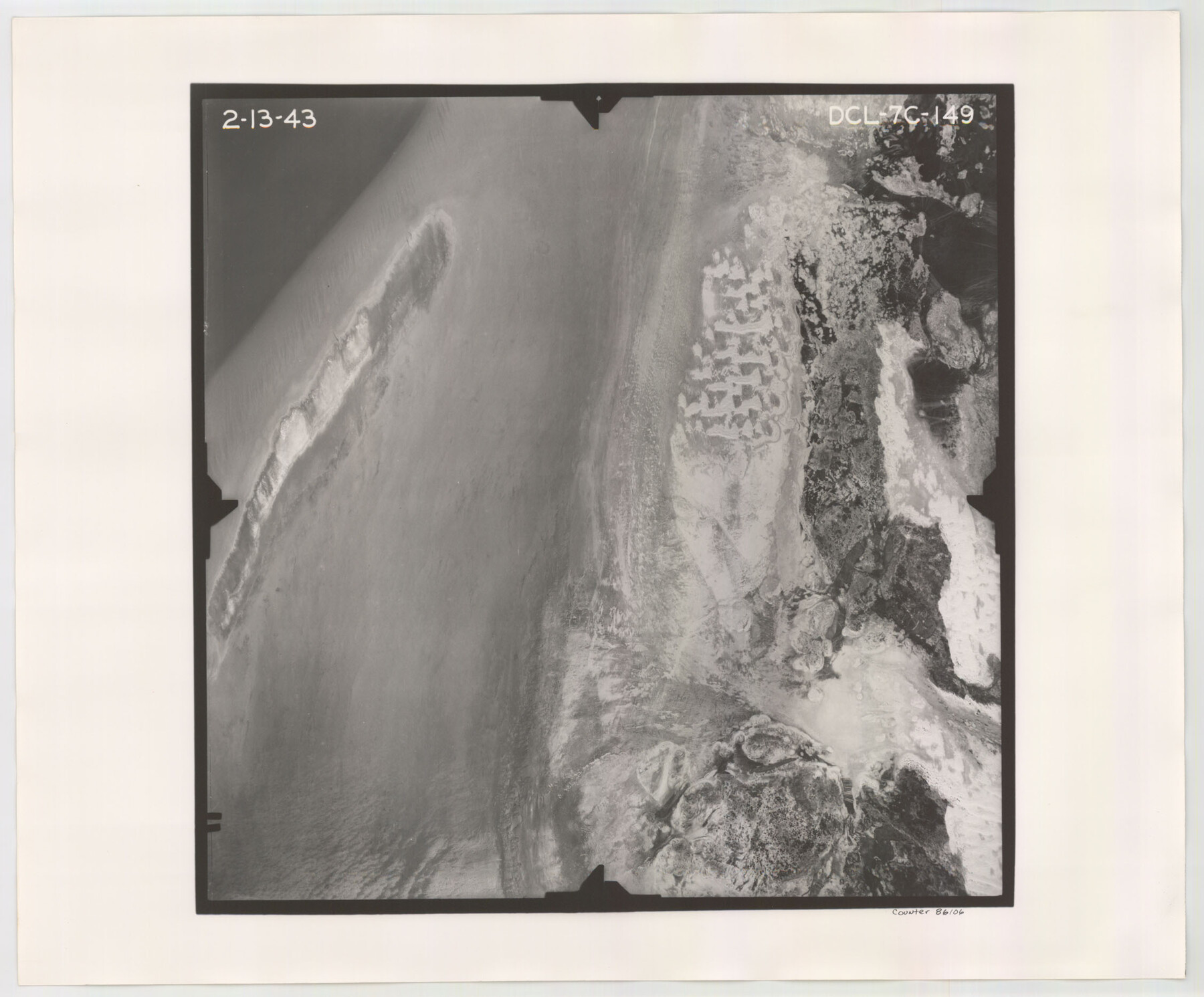
Flight Mission No. DCL-7C, Frame 149, Kenedy County
DCL-7C-149
-
Map/Doc
86106
-
Collection
General Map Collection
-
Object Dates
1943/2/13 (Creation Date)
-
People and Organizations
U. S. Department of Agriculture (Publisher)
-
Counties
Kenedy
-
Subjects
Aerial Photograph
-
Height x Width
18.7 x 22.5 inches
47.5 x 57.2 cm
-
Comments
Flown by Aerial Surveys of Pittsburgh, Inc. of Pittsburgh, Pennsylvania.
Part of: General Map Collection
Knox County Boundary File 5a

Print $22.00
- Digital $50.00
Knox County Boundary File 5a
Size 15.6 x 38.5 inches
Map/Doc 65047
Refugio County Boundary File 6a

Print $20.00
- Digital $50.00
Refugio County Boundary File 6a
Size 14.4 x 9.0 inches
Map/Doc 58262
Flight Mission No. BRE-2P, Frame 111, Nueces County

Print $20.00
- Digital $50.00
Flight Mission No. BRE-2P, Frame 111, Nueces County
1956
Size 18.4 x 22.6 inches
Map/Doc 86797
Crockett County Rolled Sketch 42A

Print $20.00
- Digital $50.00
Crockett County Rolled Sketch 42A
Size 20.3 x 24.4 inches
Map/Doc 5593
Crane County Rolled Sketch 2

Print $40.00
- Digital $50.00
Crane County Rolled Sketch 2
1888
Size 55.3 x 29.0 inches
Map/Doc 8676
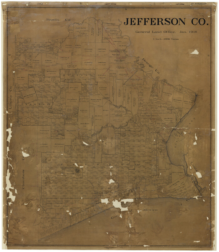
Jefferson Co.
Print $20.00
- Digital $50.00
Jefferson Co.
1918
Size 46.7 x 40.8 inches
Map/Doc 16860
Refugio County Boundary File 2

Print $32.00
- Digital $50.00
Refugio County Boundary File 2
Size 14.1 x 8.8 inches
Map/Doc 58233
Liberty County Working Sketch 38

Print $20.00
- Digital $50.00
Liberty County Working Sketch 38
1951
Size 28.0 x 36.4 inches
Map/Doc 70497
Chambers County Working Sketch 28

Print $20.00
- Digital $50.00
Chambers County Working Sketch 28
1982
Size 28.7 x 42.3 inches
Map/Doc 68011
Map of Kerr County Texas

Print $20.00
- Digital $50.00
Map of Kerr County Texas
1879
Size 20.5 x 28.5 inches
Map/Doc 4575
Intracoastal Waterway - Port Arthur to Galveston Bay

Print $20.00
- Digital $50.00
Intracoastal Waterway - Port Arthur to Galveston Bay
1961
Size 26.7 x 38.8 inches
Map/Doc 69834
Map of Bastrop District

Print $20.00
- Digital $50.00
Map of Bastrop District
1847
Size 22.9 x 28.3 inches
Map/Doc 3275
You may also like
Washington County Sketch File 7

Print $4.00
- Digital $50.00
Washington County Sketch File 7
1873
Size 12.2 x 7.6 inches
Map/Doc 39654
Hays County Sketch File 18

Print $4.00
- Digital $50.00
Hays County Sketch File 18
1878
Size 13.0 x 8.1 inches
Map/Doc 26235
Right of Way and Track Map, International & Gt. Northern Ry. Operated by the International & Gt. Northern Ry. Co., Gulf Division

Print $40.00
- Digital $50.00
Right of Way and Track Map, International & Gt. Northern Ry. Operated by the International & Gt. Northern Ry. Co., Gulf Division
1917
Size 25.1 x 56.7 inches
Map/Doc 64246
Dallam County

Print $40.00
- Digital $50.00
Dallam County
1926
Size 40.1 x 48.6 inches
Map/Doc 73125
Maverick County Working Sketch 4

Print $40.00
- Digital $50.00
Maverick County Working Sketch 4
1944
Size 51.3 x 30.7 inches
Map/Doc 70896
Nueces County Sketch File 30

Print $3.00
- Digital $50.00
Nueces County Sketch File 30
1907
Size 11.4 x 11.9 inches
Map/Doc 32600
Nueces County Rolled Sketch 53

Print $63.00
- Digital $50.00
Nueces County Rolled Sketch 53
1978
Size 10.1 x 15.1 inches
Map/Doc 47862
Hutchinson County Working Sketch 31

Print $20.00
- Digital $50.00
Hutchinson County Working Sketch 31
1978
Size 27.0 x 22.2 inches
Map/Doc 66391
Dickens County Sketch File 6

Print $34.00
- Digital $50.00
Dickens County Sketch File 6
1913
Size 9.4 x 6.1 inches
Map/Doc 20962
Concho County Working Sketch 2

Print $20.00
- Digital $50.00
Concho County Working Sketch 2
1915
Size 22.4 x 17.6 inches
Map/Doc 68184
Brewster County Rolled Sketch 114

Print $20.00
- Digital $50.00
Brewster County Rolled Sketch 114
1964
Size 12.2 x 17.5 inches
Map/Doc 5283
Brewster County Rolled Sketch 114

Print $20.00
- Digital $50.00
Brewster County Rolled Sketch 114
1964
Size 11.5 x 18.2 inches
Map/Doc 5286