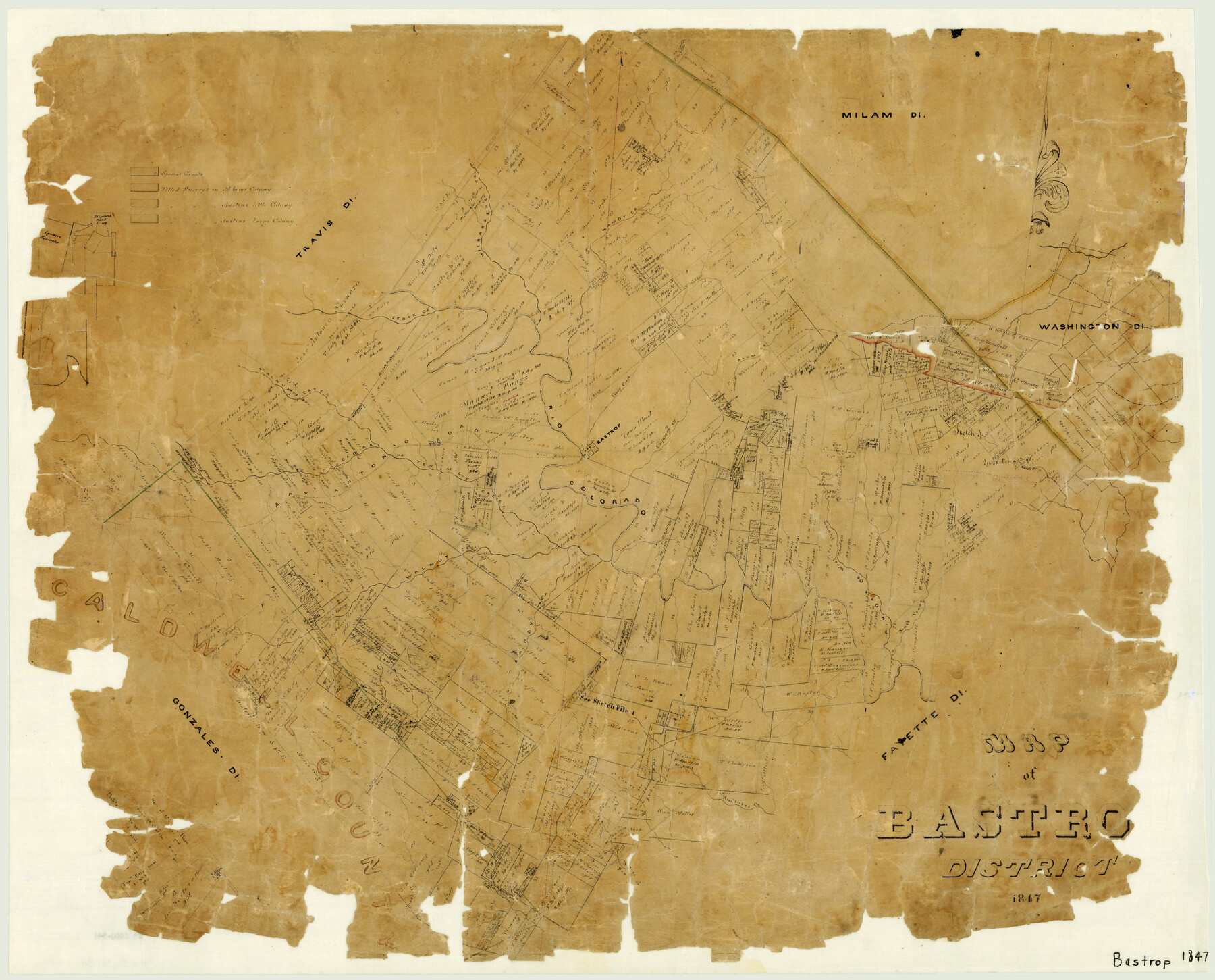
Map of Bastrop District
-
Map/Doc
3275
-
Collection
General Map Collection
-
Object Dates
1847 (Creation Date)
-
People and Organizations
Texas General Land Office (Publisher)
-
Counties
Bastrop
-
Subjects
County
-
Height x Width
22.9 x 28.3 inches
58.2 x 71.9 cm
-
Features
Goacher Trail
San Antonio Road
Turners Creek
Rabb's Creek
Peach Creek
Buckners Creek
Clay Fork of Sandy Creek
Bee Creek
Sandy Creek
East Prong of Pin Oak Creek
Sandy Creek
West Prong of Pin Oak Creek
Ten Mile Creek
Walnut Creek
Bastrop
Rio Colorado
Piney Creek
Alum Creek
Cedar Creek
Wilbarger Creek
Part of: General Map Collection
No. 2 Chart of Corpus Christi Pass, Texas

Print $20.00
- Digital $50.00
No. 2 Chart of Corpus Christi Pass, Texas
1878
Size 18.2 x 27.2 inches
Map/Doc 73029
Reagan County Sketch File 10

Print $40.00
- Digital $50.00
Reagan County Sketch File 10
1928
Size 13.7 x 14.2 inches
Map/Doc 34989
Flight Mission No. BRA-8M, Frame 76, Jefferson County

Print $20.00
- Digital $50.00
Flight Mission No. BRA-8M, Frame 76, Jefferson County
1953
Size 18.5 x 22.3 inches
Map/Doc 85596
Map of Van Zandt County

Print $20.00
- Digital $50.00
Map of Van Zandt County
1853
Size 19.4 x 20.6 inches
Map/Doc 16957
Dawson County Sketch File 27

Print $8.00
- Digital $50.00
Dawson County Sketch File 27
Size 12.6 x 8.5 inches
Map/Doc 20588
Jim Hogg County Working Sketch 5

Print $20.00
- Digital $50.00
Jim Hogg County Working Sketch 5
1941
Size 40.8 x 41.0 inches
Map/Doc 66591
Flight Mission No. BRA-6M, Frame 87, Jefferson County

Print $20.00
- Digital $50.00
Flight Mission No. BRA-6M, Frame 87, Jefferson County
1953
Size 18.5 x 22.3 inches
Map/Doc 85430
El Paso County Rolled Sketch 52

Print $20.00
- Digital $50.00
El Paso County Rolled Sketch 52
1929
Size 18.5 x 24.3 inches
Map/Doc 5849
Map of the Lands belonging to the Texas Land & Cattle Co. situated in Wharton, Matagorda and Jackson Counties, Texas

Print $20.00
- Digital $50.00
Map of the Lands belonging to the Texas Land & Cattle Co. situated in Wharton, Matagorda and Jackson Counties, Texas
1904
Size 24.6 x 38.5 inches
Map/Doc 94020
Map of Augustine Cty.

Print $20.00
- Digital $50.00
Map of Augustine Cty.
1839
Size 22.9 x 14.6 inches
Map/Doc 165
Brooks County Boundary File 1b

Print $20.00
- Digital $50.00
Brooks County Boundary File 1b
Size 42.2 x 6.6 inches
Map/Doc 50837
El Paso County Sketch File 1a

Print $4.00
- Digital $50.00
El Paso County Sketch File 1a
Size 12.1 x 8.2 inches
Map/Doc 21907
You may also like
Leon County Rolled Sketch 19

Print $20.00
- Digital $50.00
Leon County Rolled Sketch 19
1982
Size 23.9 x 37.4 inches
Map/Doc 6605
Live Oak County Sketch File 6

Print $4.00
- Digital $50.00
Live Oak County Sketch File 6
1847
Size 9.9 x 7.8 inches
Map/Doc 30257
The Republic County of Harrison. December 29, 1845

Print $20.00
The Republic County of Harrison. December 29, 1845
2020
Size 18.6 x 21.7 inches
Map/Doc 96177

Erath County Working Sketch 16

Print $20.00
- Digital $50.00
Erath County Working Sketch 16
1961
Size 20.9 x 26.5 inches
Map/Doc 69097
A Map of that part of Young District south of old Fannin District line

Print $20.00
- Digital $50.00
A Map of that part of Young District south of old Fannin District line
1861
Size 24.9 x 38.0 inches
Map/Doc 1979
Hopkins County Sketch File 2

Print $28.00
- Digital $50.00
Hopkins County Sketch File 2
1845
Size 11.1 x 7.9 inches
Map/Doc 26678
Gillespie County Working Sketch 8

Print $20.00
- Digital $50.00
Gillespie County Working Sketch 8
1993
Size 31.1 x 24.2 inches
Map/Doc 63171
Record of Field Notes in Austin's Colony

Record of Field Notes in Austin's Colony
1837
Map/Doc 96673
Chambers County Rolled Sketch FD

Print $20.00
- Digital $50.00
Chambers County Rolled Sketch FD
1935
Size 32.7 x 26.5 inches
Map/Doc 5433
Sectional Map No. 3 of the lands and of the line of the Texas & Pacific Ry. Co. in Reeves and parts of Tom Green, Pecos, Presidio & El Paso Cos.

Print $20.00
- Digital $50.00
Sectional Map No. 3 of the lands and of the line of the Texas & Pacific Ry. Co. in Reeves and parts of Tom Green, Pecos, Presidio & El Paso Cos.
1885
Size 24.2 x 18.9 inches
Map/Doc 4858
Flight Mission No. DCL-6C, Frame 28, Kenedy County

Print $20.00
- Digital $50.00
Flight Mission No. DCL-6C, Frame 28, Kenedy County
1943
Size 18.7 x 22.4 inches
Map/Doc 85885