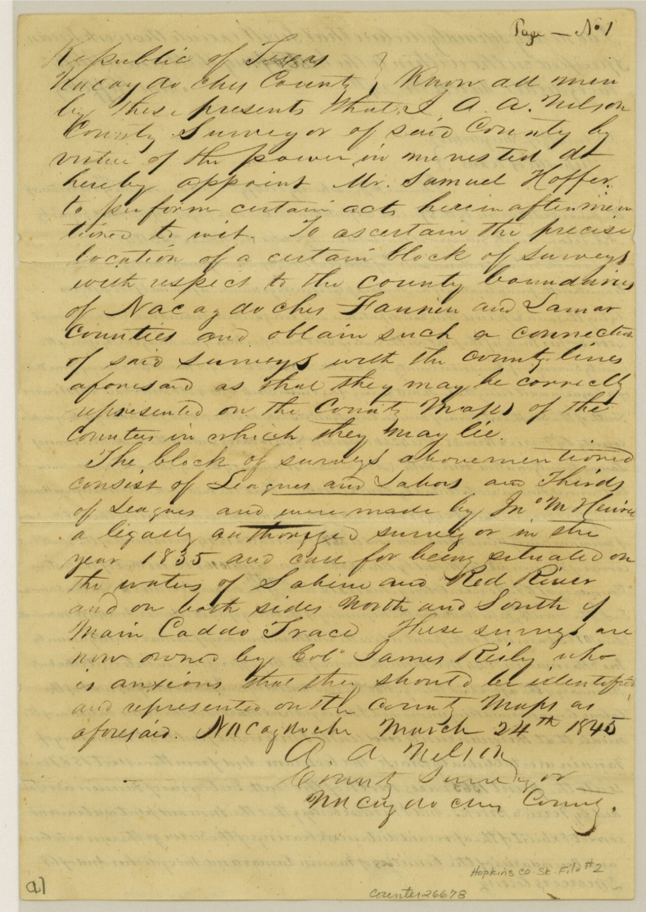
Hopkins County Sketch File 2
[Report and plat of James Reily tract]
-
Map/Doc
26678
-
Collection
General Map Collection
-
Object Dates
3/24/1845 (Creation Date)
6/2/1845 (File Date)
1844 (Survey Date)
4/5/1845 (Creation Date)
-
People and Organizations
Samuel Hoffer (Surveyor/Engineer)
A.A. Nelson (Surveyor/Engineer)
Ferris & Brooks (Surveyor/Engineer)
Black & Cochrane (Surveyor/Engineer)
Jno. G. Harman (Surveyor/Engineer)
John Garrett (Chainman)
Thomas T. Havins (Chainman)
-
Counties
Hopkins Fannin Lamar Nacogdoches
-
Subjects
Surveying Sketch File
-
Height x Width
11.1 x 7.9 inches
28.2 x 20.1 cm
-
Medium
paper, manuscript
-
Scale
1:4000; 1:2000
-
Features
Sabine River
Red River
Caddo Trace
Mercer's Colony
White Oak Fork of Sulphur Creek
Lake Fork of Sabine River
Turkey Creek
Garrett Creek
Kickapoo Trace
Burke's Creek
Part of: General Map Collection
Flight Mission No. CGI-4N, Frame 196, Cameron County

Print $20.00
- Digital $50.00
Flight Mission No. CGI-4N, Frame 196, Cameron County
1955
Size 18.5 x 22.2 inches
Map/Doc 84699
Presidio County Sketch File 41

Print $6.00
- Digital $50.00
Presidio County Sketch File 41
Size 10.3 x 8.3 inches
Map/Doc 34515
Live Oak County Sketch File 6

Print $4.00
- Digital $50.00
Live Oak County Sketch File 6
1847
Size 9.9 x 7.8 inches
Map/Doc 30257
Outer Continental Shelf Leasing Maps (Louisiana Offshore Operations)

Print $20.00
- Digital $50.00
Outer Continental Shelf Leasing Maps (Louisiana Offshore Operations)
1954
Size 11.3 x 12.4 inches
Map/Doc 76117
Kinney County Working Sketch 4

Print $20.00
- Digital $50.00
Kinney County Working Sketch 4
1907
Size 21.1 x 21.6 inches
Map/Doc 70186
Houston County

Print $20.00
- Digital $50.00
Houston County
1868
Size 25.5 x 26.1 inches
Map/Doc 3685
Jim Hogg County Rolled Sketch EJ

Print $40.00
- Digital $50.00
Jim Hogg County Rolled Sketch EJ
1933
Size 50.7 x 37.0 inches
Map/Doc 9321
Flight Mission No. DCL-7C, Frame 69, Kenedy County

Print $20.00
- Digital $50.00
Flight Mission No. DCL-7C, Frame 69, Kenedy County
1943
Size 15.4 x 15.2 inches
Map/Doc 86055
Map of Reeves County

Print $20.00
- Digital $50.00
Map of Reeves County
1892
Size 44.8 x 34.0 inches
Map/Doc 3983

Anderson County Rolled Sketch 15

Print $20.00
- Digital $50.00
Anderson County Rolled Sketch 15
2002
Size 40.0 x 28.3 inches
Map/Doc 78315
Matagorda Bay and Approaches

Print $20.00
- Digital $50.00
Matagorda Bay and Approaches
1989
Size 36.3 x 45.0 inches
Map/Doc 73389
You may also like
Fayette County Sketch File 3

Print $6.00
- Digital $50.00
Fayette County Sketch File 3
1863
Size 8.3 x 10.7 inches
Map/Doc 22501
Ector County Working Sketch 5

Print $20.00
- Digital $50.00
Ector County Working Sketch 5
1941
Size 44.7 x 27.1 inches
Map/Doc 68848
Flight Mission No. BQY-4M, Frame 33, Harris County

Print $20.00
- Digital $50.00
Flight Mission No. BQY-4M, Frame 33, Harris County
1953
Size 18.7 x 22.4 inches
Map/Doc 85248
Gaines County Rolled Sketch 35

Print $20.00
- Digital $50.00
Gaines County Rolled Sketch 35
2014
Size 18.7 x 25.9 inches
Map/Doc 93695
Fannin County Rolled Sketch 18F

Print $2.00
- Digital $50.00
Fannin County Rolled Sketch 18F
Size 8.9 x 8.2 inches
Map/Doc 5873
Aransas County NRC Article 33.136 Sketch 8

Print $22.00
- Digital $50.00
Aransas County NRC Article 33.136 Sketch 8
2007
Size 24.0 x 36.0 inches
Map/Doc 88800
Brazoria County Rolled Sketch AH

Print $20.00
- Digital $50.00
Brazoria County Rolled Sketch AH
Size 43.9 x 31.2 inches
Map/Doc 10714
Kleberg County Rolled Sketch 10-42

Print $20.00
- Digital $50.00
Kleberg County Rolled Sketch 10-42
1952
Size 42.7 x 36.4 inches
Map/Doc 9380
Brown County Working Sketch 19

Print $20.00
- Digital $50.00
Brown County Working Sketch 19
1998
Size 37.1 x 34.8 inches
Map/Doc 67784
Brazoria County Sketch File 30

Print $4.00
- Digital $50.00
Brazoria County Sketch File 30
1893
Size 11.1 x 8.7 inches
Map/Doc 15037
Scurry County Sketch Mineral Application No. 42315

Print $20.00
- Digital $50.00
Scurry County Sketch Mineral Application No. 42315
1950
Size 24.0 x 16.5 inches
Map/Doc 92965
Map of the Lands Surveyed by the Memphis, El Paso & Pacific R.R. Company

Print $20.00
- Digital $50.00
Map of the Lands Surveyed by the Memphis, El Paso & Pacific R.R. Company
1859
Size 11.4 x 18.6 inches
Map/Doc 4850