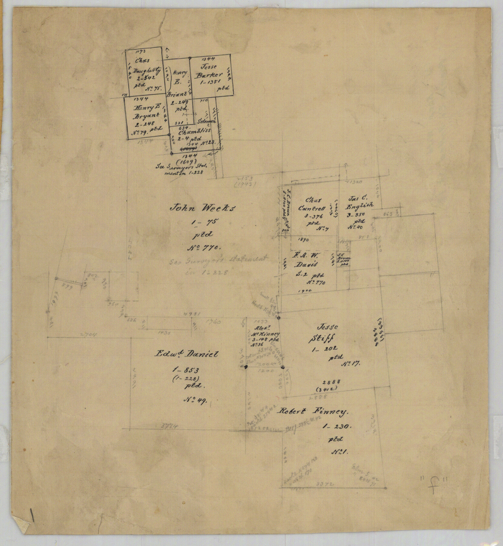
Fannin County Rolled Sketch 18F
[Old sketch of surveys around the John Weeks survey in west part of county]
-
Map/Doc
5873
-
Collection
General Map Collection
-
Counties
Fannin
-
Subjects
Surveying Rolled Sketch
-
Height x Width
8.9 x 8.2 inches
22.6 x 20.8 cm
-
Medium
paper, manuscript
Part of: General Map Collection
Coke County Working Sketch 24

Print $20.00
- Digital $50.00
Coke County Working Sketch 24
1956
Size 28.7 x 31.1 inches
Map/Doc 68061
McMullen County Sketch File 28

Print $20.00
- Digital $50.00
McMullen County Sketch File 28
1884
Size 24.8 x 28.1 inches
Map/Doc 12061
Freestone County Sketch File 16

Print $4.00
- Digital $50.00
Freestone County Sketch File 16
Size 6.4 x 8.7 inches
Map/Doc 23072
Dallas County Sketch File 16

Print $4.00
- Digital $50.00
Dallas County Sketch File 16
Size 8.0 x 8.4 inches
Map/Doc 20435
Trinity County Boundary File 102

Print $14.00
- Digital $50.00
Trinity County Boundary File 102
Size 9.2 x 4.6 inches
Map/Doc 59480
Milam County Sketch File 8

Print $20.00
- Digital $50.00
Milam County Sketch File 8
1856
Size 16.8 x 33.7 inches
Map/Doc 12091
Navarro County Sketch File 15

Print $4.00
- Digital $50.00
Navarro County Sketch File 15
1878
Size 7.6 x 10.0 inches
Map/Doc 32328
Map of Bexar County

Print $40.00
- Digital $50.00
Map of Bexar County
1845
Size 48.8 x 43.0 inches
Map/Doc 87237
Throckmorton County

Print $20.00
- Digital $50.00
Throckmorton County
1943
Size 40.1 x 32.8 inches
Map/Doc 77435
Falls County Sketch File 18a

Print $8.00
- Digital $50.00
Falls County Sketch File 18a
Size 13.3 x 9.0 inches
Map/Doc 22382
Map of the Straits of Florida and Gulf of Mexico

Print $20.00
- Digital $50.00
Map of the Straits of Florida and Gulf of Mexico
1851
Size 18.4 x 27.5 inches
Map/Doc 72674
Brewster County Rolled Sketch 151

Print $20.00
- Digital $50.00
Brewster County Rolled Sketch 151
1996
Size 36.3 x 28.0 inches
Map/Doc 5318
You may also like
Harris County Sketch File A

Print $4.00
- Digital $50.00
Harris County Sketch File A
1898
Size 12.8 x 8.5 inches
Map/Doc 25306
Van Zandt County

Print $40.00
- Digital $50.00
Van Zandt County
1921
Size 43.3 x 48.1 inches
Map/Doc 93124
Polk County Sketch File 27

Print $8.00
- Digital $50.00
Polk County Sketch File 27
1891
Size 14.1 x 8.7 inches
Map/Doc 34194
Cass County Sketch File 5 and 5a

Print $6.00
- Digital $50.00
Cass County Sketch File 5 and 5a
1851
Size 2.8 x 5.1 inches
Map/Doc 17401
Flight Mission No. BRA-16M, Frame 98, Jefferson County

Print $20.00
- Digital $50.00
Flight Mission No. BRA-16M, Frame 98, Jefferson County
1953
Size 18.7 x 22.4 inches
Map/Doc 85710
Flight Mission No. BRA-7M, Frame 16, Jefferson County

Print $20.00
- Digital $50.00
Flight Mission No. BRA-7M, Frame 16, Jefferson County
1953
Size 18.5 x 22.2 inches
Map/Doc 85467
Ward County Working Sketch 51

Print $40.00
- Digital $50.00
Ward County Working Sketch 51
1980
Size 34.4 x 52.1 inches
Map/Doc 72357
Galveston County Rolled Sketch 23

Print $24.00
- Digital $50.00
Galveston County Rolled Sketch 23
1955
Size 10.0 x 15.2 inches
Map/Doc 45081
Erath County Working Sketch 34

Print $20.00
- Digital $50.00
Erath County Working Sketch 34
1972
Size 38.7 x 25.3 inches
Map/Doc 69115
Trinity River, Onion Creek Station Sheet/Chambers Creek

Print $6.00
- Digital $50.00
Trinity River, Onion Creek Station Sheet/Chambers Creek
1931
Size 35.1 x 32.4 inches
Map/Doc 65234
Flight Mission No. CGI-4N, Frame 25, Cameron County

Print $20.00
- Digital $50.00
Flight Mission No. CGI-4N, Frame 25, Cameron County
1954
Size 18.7 x 22.4 inches
Map/Doc 84658
Upshur County Working Sketch 14

Print $20.00
- Digital $50.00
Upshur County Working Sketch 14
1993
Size 23.1 x 37.1 inches
Map/Doc 69571