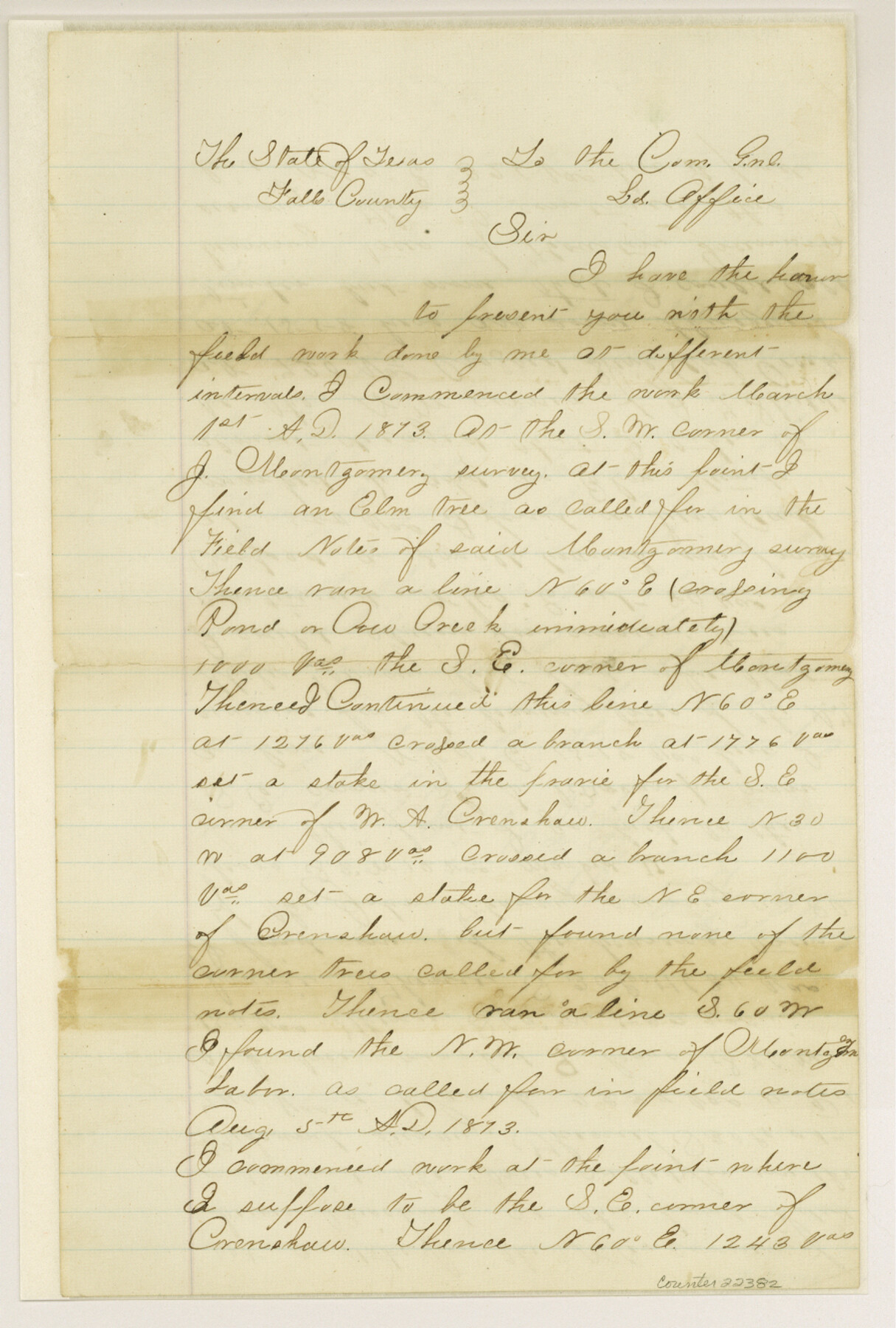
Falls County Sketch File 18a
[Explanation regarding surveys on Pond Creek]
-
Map/Doc
22382
-
Collection
General Map Collection
-
Object Dates
1873/8/27 (File Date)
1873/3/1 (Survey Date)
-
People and Organizations
Ed Pierson (Surveyor/Engineer)
-
Counties
Falls
-
Subjects
Surveying Sketch File
-
Height x Width
13.3 x 9.0 inches
33.8 x 22.9 cm
-
Medium
paper, manuscript
-
Features
Pond Creek
Cow Creek
Part of: General Map Collection
Lubbock County Boundary File 10

Print $108.00
- Digital $50.00
Lubbock County Boundary File 10
Size 14.3 x 8.7 inches
Map/Doc 56549
Houston County Sketch File 6a

Print $4.00
- Digital $50.00
Houston County Sketch File 6a
Size 10.2 x 8.1 inches
Map/Doc 26762
Webb County Working Sketch 21

Print $20.00
- Digital $50.00
Webb County Working Sketch 21
1926
Size 28.7 x 24.7 inches
Map/Doc 72386
McMullen County Rolled Sketch 20

Print $20.00
- Digital $50.00
McMullen County Rolled Sketch 20
Size 27.7 x 21.7 inches
Map/Doc 6736
Hopkins County Working Sketch Graphic Index

Print $20.00
- Digital $50.00
Hopkins County Working Sketch Graphic Index
1942
Size 40.6 x 38.7 inches
Map/Doc 76581

Archer County Sketch File 8b

Print $42.00
- Digital $50.00
Archer County Sketch File 8b
1890
Map/Doc 88497
Frio County Rolled Sketch 3

Print $20.00
- Digital $50.00
Frio County Rolled Sketch 3
Size 30.7 x 20.1 inches
Map/Doc 5916
Wichita County Working Sketch 15

Print $20.00
- Digital $50.00
Wichita County Working Sketch 15
1919
Size 29.9 x 38.5 inches
Map/Doc 72525
Eastland County Working Sketch 31

Print $20.00
- Digital $50.00
Eastland County Working Sketch 31
1955
Size 33.9 x 33.9 inches
Map/Doc 68812
Chambers County Working Sketch 29

Print $20.00
- Digital $50.00
Chambers County Working Sketch 29
2009
Size 25.2 x 18.6 inches
Map/Doc 89232
Lampasas County Sketch File 3

Print $4.00
- Digital $50.00
Lampasas County Sketch File 3
1856
Size 12.1 x 7.6 inches
Map/Doc 29392
You may also like
Located Line of the Panhandle & Gulf Ry. Through State Lands, Public School and University, in Crockett County, Texas

Print $20.00
- Digital $50.00
Located Line of the Panhandle & Gulf Ry. Through State Lands, Public School and University, in Crockett County, Texas
1904
Size 12.2 x 27.3 inches
Map/Doc 64287
Right of Way and Track Map, International & Gt. Northern Ry. Operated by the International & Gt. Northern Ry. Co., Gulf Division

Print $40.00
- Digital $50.00
Right of Way and Track Map, International & Gt. Northern Ry. Operated by the International & Gt. Northern Ry. Co., Gulf Division
1917
Size 25.1 x 56.7 inches
Map/Doc 64246
Garza County Sketch File D

Print $20.00
- Digital $50.00
Garza County Sketch File D
1901
Size 18.4 x 12.2 inches
Map/Doc 11550
Edwards County Working Sketch 107

Print $40.00
- Digital $50.00
Edwards County Working Sketch 107
1972
Size 54.5 x 38.8 inches
Map/Doc 68983
Reagan County Sketch File 29

Print $20.00
- Digital $50.00
Reagan County Sketch File 29
1951
Size 21.3 x 30.5 inches
Map/Doc 12225
Collin County Working Sketch 1

Print $20.00
- Digital $50.00
Collin County Working Sketch 1
1921
Size 26.6 x 23.4 inches
Map/Doc 68095
Portion of Pecos County

Print $20.00
- Digital $50.00
Portion of Pecos County
Size 18.8 x 21.6 inches
Map/Doc 91589
Blanco County Boundary File 4

Print $24.00
- Digital $50.00
Blanco County Boundary File 4
Size 8.9 x 8.3 inches
Map/Doc 50543

Rusk County Working Sketch 26

Print $20.00
- Digital $50.00
Rusk County Working Sketch 26
1938
Size 42.8 x 36.8 inches
Map/Doc 63662
[Sketch showing School Lands]
![90286, [Sketch showing School Lands], Twichell Survey Records](https://historictexasmaps.com/wmedia_w700/maps/90286-1.tif.jpg)
Print $20.00
- Digital $50.00
[Sketch showing School Lands]
Size 24.1 x 18.1 inches
Map/Doc 90286
Hockley County Sketch Mineral Application Number 38322- 38379

Print $20.00
- Digital $50.00
Hockley County Sketch Mineral Application Number 38322- 38379
1946
Size 34.1 x 27.8 inches
Map/Doc 92242