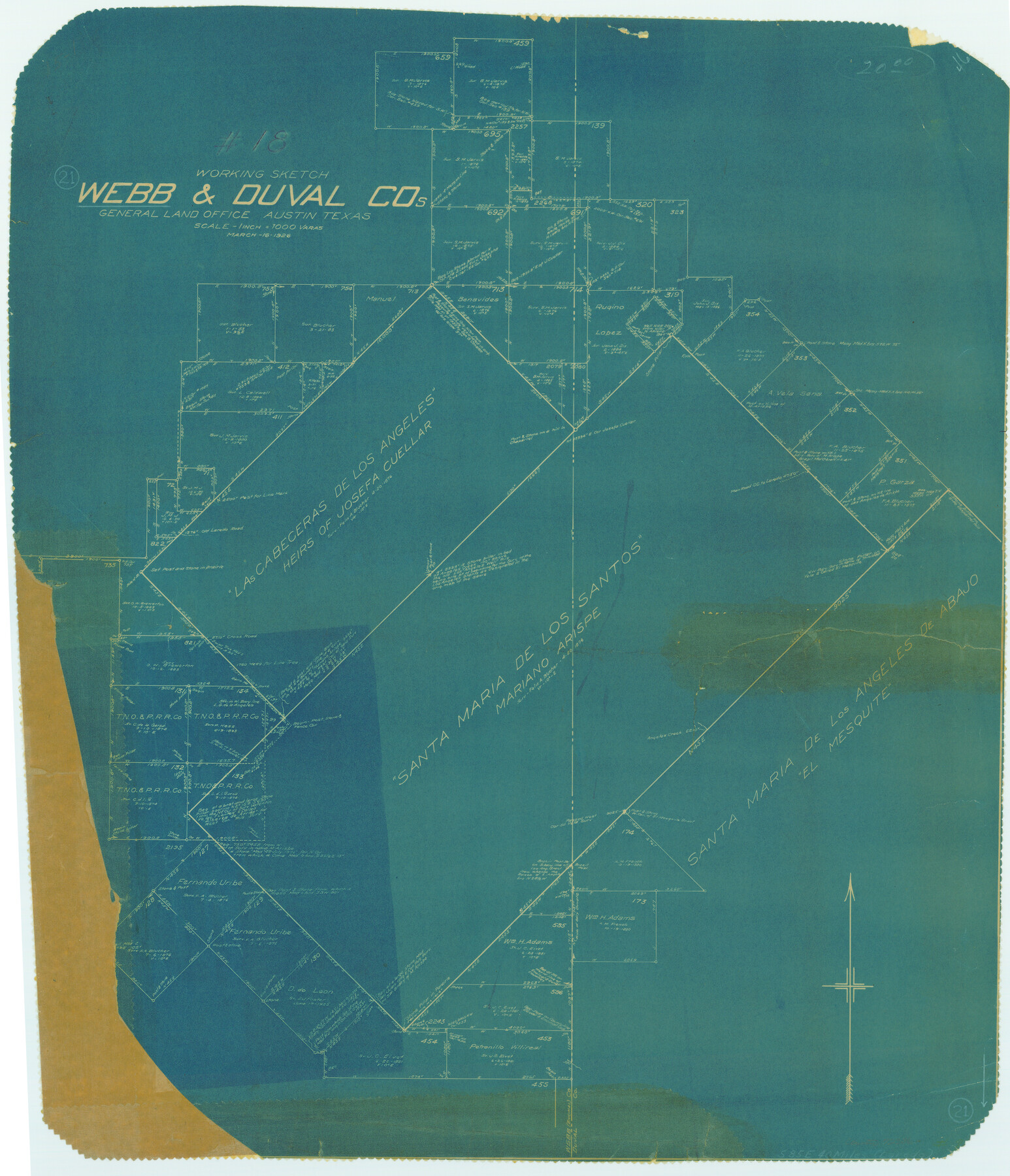
Webb County Working Sketch 21
-
Map/Doc
72386
-
Collection
General Map Collection
-
Object Dates
3/16/1926 (Creation Date)
-
Counties
Webb Duval
-
Subjects
Surveying Working Sketch
-
Height x Width
28.7 x 24.7 inches
72.9 x 62.7 cm
-
Scale
1" = 1000 varas
Part of: General Map Collection
Hutchinson County Rolled Sketch 6

Print $20.00
- Digital $50.00
Hutchinson County Rolled Sketch 6
1906
Size 33.2 x 24.2 inches
Map/Doc 6278
Wharton County Working Sketch Graphic Index

Print $20.00
- Digital $50.00
Wharton County Working Sketch Graphic Index
1946
Size 41.7 x 47.5 inches
Map/Doc 76737
Brazoria County NRC Article 33.136 Sketch 25

Print $134.00
Brazoria County NRC Article 33.136 Sketch 25
2025
Map/Doc 97440
Harrison County Working Sketch 13

Print $20.00
- Digital $50.00
Harrison County Working Sketch 13
1961
Size 32.4 x 37.0 inches
Map/Doc 66033
Henderson County

Print $40.00
- Digital $50.00
Henderson County
1922
Size 39.3 x 49.1 inches
Map/Doc 4683
Map of Ramon Musquiz Survey, Meanders of Lavaca & Navidad Rivers, Menefee & Redfish Lakes

Print $20.00
- Digital $50.00
Map of Ramon Musquiz Survey, Meanders of Lavaca & Navidad Rivers, Menefee & Redfish Lakes
1934
Size 24.4 x 18.0 inches
Map/Doc 65453
Hutchinson County Working Sketch 17

Print $20.00
- Digital $50.00
Hutchinson County Working Sketch 17
Size 45.8 x 44.2 inches
Map/Doc 66376


Atascosa County Working Sketch 30

Print $20.00
- Digital $50.00
Atascosa County Working Sketch 30
1980
Size 16.4 x 20.6 inches
Map/Doc 67226
Presidio County Sketch File 89

Print $10.00
- Digital $50.00
Presidio County Sketch File 89
1953
Size 14.3 x 8.9 inches
Map/Doc 34756
Grimes County Working Sketch 18

Print $20.00
- Digital $50.00
Grimes County Working Sketch 18
1990
Size 33.1 x 42.5 inches
Map/Doc 63309
You may also like
Rio Grande from San Juan River to the Gulf of Mexico showing Boundary between the United States and Mexico

Print $20.00
- Digital $50.00
Rio Grande from San Juan River to the Gulf of Mexico showing Boundary between the United States and Mexico
1903
Size 25.6 x 15.8 inches
Map/Doc 2065
Brazoria County Rolled Sketch 49

Print $20.00
- Digital $50.00
Brazoria County Rolled Sketch 49
1948
Size 23.8 x 36.0 inches
Map/Doc 5185
Outer Continental Shelf Leasing Maps (Louisiana Offshore Operations)

Print $20.00
- Digital $50.00
Outer Continental Shelf Leasing Maps (Louisiana Offshore Operations)
1959
Size 17.9 x 13.8 inches
Map/Doc 76104
Land Owned by the Cedar Valley Land and Cattle Co. are M.K.O.

Print $20.00
- Digital $50.00
Land Owned by the Cedar Valley Land and Cattle Co. are M.K.O.
Size 21.4 x 16.5 inches
Map/Doc 91758
Controlled Mosaic by Jack Amman Photogrammetric Engineers, Inc - Sheet 51

Print $20.00
- Digital $50.00
Controlled Mosaic by Jack Amman Photogrammetric Engineers, Inc - Sheet 51
1954
Size 20.0 x 24.0 inches
Map/Doc 83510
Edwards County Working Sketch 45

Print $40.00
- Digital $50.00
Edwards County Working Sketch 45
1950
Size 65.4 x 43.4 inches
Map/Doc 68921
[Canadian River North]
![91826, [Canadian River North], Twichell Survey Records](https://historictexasmaps.com/wmedia_w700/maps/91826-1.tif.jpg)
Print $3.00
- Digital $50.00
[Canadian River North]
Size 17.9 x 11.7 inches
Map/Doc 91826
Section M, Tech Memorial Park, Inc.

Print $2.00
- Digital $50.00
Section M, Tech Memorial Park, Inc.
1950
Size 7.6 x 11.8 inches
Map/Doc 92271
Flight Mission No. DQN-5K, Frame 74, Calhoun County

Print $20.00
- Digital $50.00
Flight Mission No. DQN-5K, Frame 74, Calhoun County
1953
Size 18.5 x 22.2 inches
Map/Doc 84407
Boundary Between the United States & Mexico Agreed Upon by the Joint Commission under the Treaty of Guadalupe Hidalgo

Print $20.00
- Digital $50.00
Boundary Between the United States & Mexico Agreed Upon by the Joint Commission under the Treaty of Guadalupe Hidalgo
1853
Size 24.0 x 18.3 inches
Map/Doc 65396
Pecos County Working Sketch 42

Print $20.00
- Digital $50.00
Pecos County Working Sketch 42
1942
Size 31.3 x 23.9 inches
Map/Doc 71514
San Augustine County Sketch File 1

Print $4.00
San Augustine County Sketch File 1
1849
Size 9.3 x 8.2 inches
Map/Doc 35631