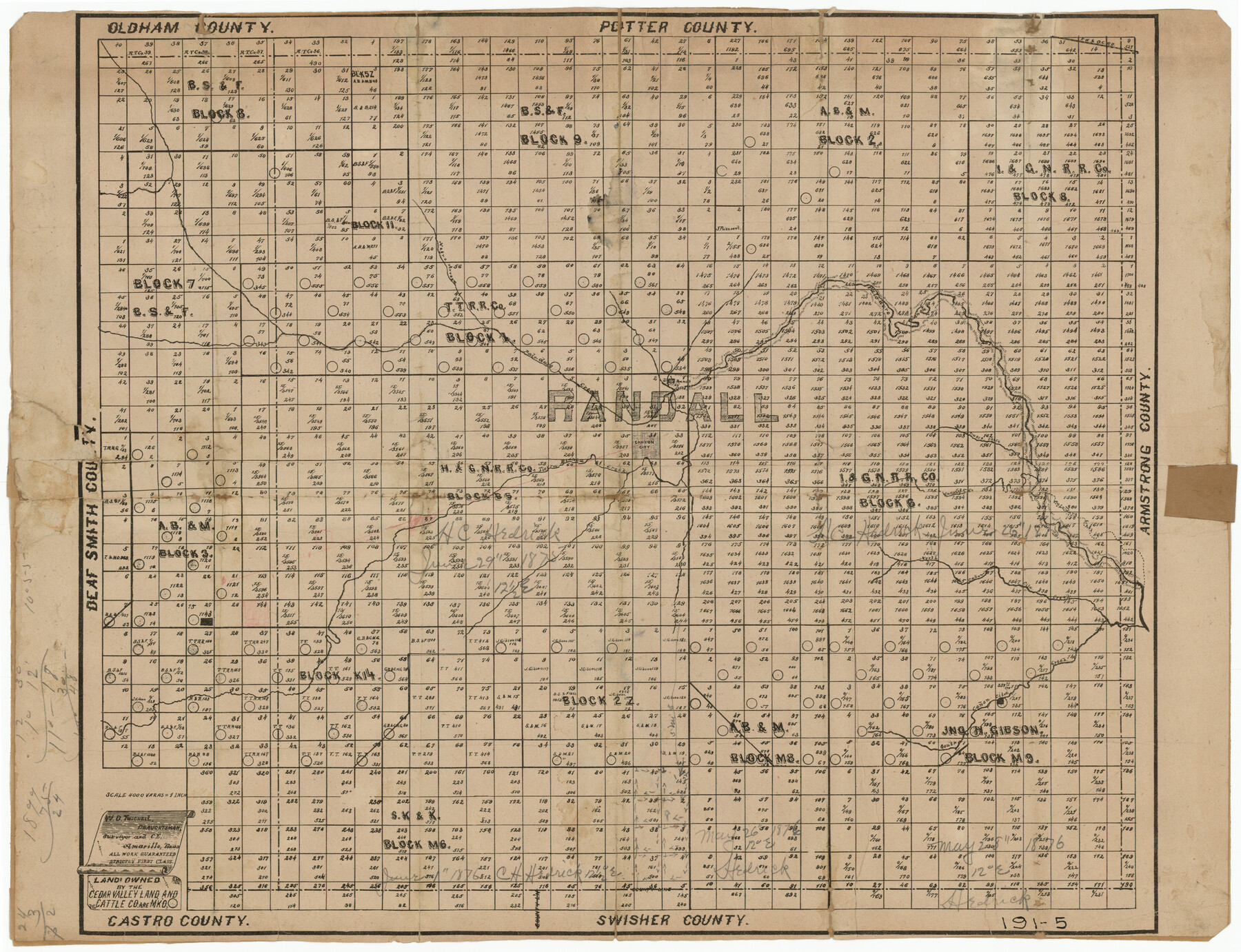
Land Owned by the Cedar Valley Land and Cattle Co. are M.K.O.
191-5
-
Map/Doc
91758
-
Collection
Twichell Survey Records
-
People and Organizations
W.D. Twichell (Draftsman)
W.D. Twichell (Surveyor/Engineer)
-
Counties
Randall
-
Height x Width
21.4 x 16.5 inches
54.4 x 41.9 cm
Part of: Twichell Survey Records
Bravo Deed, Instrument 24, Tract A and Tract B

Print $3.00
- Digital $50.00
Bravo Deed, Instrument 24, Tract A and Tract B
Size 11.4 x 14.2 inches
Map/Doc 91479
[E. T. Ry. Blk. 1]
![89794, [E. T. Ry. Blk. 1], Twichell Survey Records](https://historictexasmaps.com/wmedia_w700/maps/89794-1.tif.jpg)
Print $40.00
- Digital $50.00
[E. T. Ry. Blk. 1]
Size 56.5 x 43.4 inches
Map/Doc 89794
Battlefields of the Civil War

Battlefields of the Civil War
1961
Size 25.8 x 19.7 inches
Map/Doc 92374
Sketch in Gray County

Print $20.00
- Digital $50.00
Sketch in Gray County
1910
Size 15.1 x 18.5 inches
Map/Doc 90741
Property of Hobbs Trailers Manufacturing Company

Print $20.00
- Digital $50.00
Property of Hobbs Trailers Manufacturing Company
1956
Size 36.6 x 18.9 inches
Map/Doc 92733
Sections 13 & 12, Block S

Print $20.00
- Digital $50.00
Sections 13 & 12, Block S
Size 23.0 x 18.2 inches
Map/Doc 92835
[Sketch showing Blocks B-11, G and M-2 and 3, L, and 47, Sections 77-102]
![91733, [Sketch showing Blocks B-11, G and M-2 and 3, L, and 47, Sections 77-102], Twichell Survey Records](https://historictexasmaps.com/wmedia_w700/maps/91733-1.tif.jpg)
Print $20.00
- Digital $50.00
[Sketch showing Blocks B-11, G and M-2 and 3, L, and 47, Sections 77-102]
Size 25.4 x 18.8 inches
Map/Doc 91733
Map of Reeves County, 1892

Print $20.00
- Digital $50.00
Map of Reeves County, 1892
1892
Size 35.8 x 46.3 inches
Map/Doc 89708
W. S. Mabry Land Corners and Connections, Potter County

Print $20.00
- Digital $50.00
W. S. Mabry Land Corners and Connections, Potter County
Size 22.6 x 17.5 inches
Map/Doc 91806
[Capitol Leagues in Lamb County]
![91013, [Capitol Leagues in Lamb County], Twichell Survey Records](https://historictexasmaps.com/wmedia_w700/maps/91013-1.tif.jpg)
Print $2.00
- Digital $50.00
[Capitol Leagues in Lamb County]
1912
Size 13.1 x 8.8 inches
Map/Doc 91013
[Survey 321, Double Lakes Area Northwest of Tahoka]
![89962, [Survey 321, Double Lakes Area Northwest of Tahoka], Twichell Survey Records](https://historictexasmaps.com/wmedia_w700/maps/89962-1.tif.jpg)
Print $20.00
- Digital $50.00
[Survey 321, Double Lakes Area Northwest of Tahoka]
Size 41.3 x 43.0 inches
Map/Doc 89962
[Leagues 571- 575, 578- 583, 603- 609, and Surrounding Surveys]
![91065, [Leagues 571- 575, 578- 583, 603- 609, and Surrounding Surveys], Twichell Survey Records](https://historictexasmaps.com/wmedia_w700/maps/91065-1.tif.jpg)
Print $20.00
- Digital $50.00
[Leagues 571- 575, 578- 583, 603- 609, and Surrounding Surveys]
Size 43.2 x 12.5 inches
Map/Doc 91065
You may also like
Farm Owned by Dr. J. T. Krueger

Print $20.00
- Digital $50.00
Farm Owned by Dr. J. T. Krueger
Size 16.9 x 32.8 inches
Map/Doc 92344
Guadalupe County Working Sketch 4

Print $20.00
- Digital $50.00
Guadalupe County Working Sketch 4
1939
Size 17.7 x 10.8 inches
Map/Doc 63313
Crane County Boundary File 1b

Print $80.00
- Digital $50.00
Crane County Boundary File 1b
Size 85.1 x 17.9 inches
Map/Doc 51969
[Part of Connected map of Stephen F. Austin's Colony on file at the GLO]
![90208, [Part of Connected map of Stephen F. Austin's Colony on file at the GLO], Twichell Survey Records](https://historictexasmaps.com/wmedia_w700/maps/90208-1.tif.jpg)
Print $20.00
- Digital $50.00
[Part of Connected map of Stephen F. Austin's Colony on file at the GLO]
1923
Size 18.8 x 18.2 inches
Map/Doc 90208
Flight Mission No. BRA-6M, Frame 81, Jefferson County

Print $20.00
- Digital $50.00
Flight Mission No. BRA-6M, Frame 81, Jefferson County
1953
Size 18.6 x 22.6 inches
Map/Doc 85425
Angelina County Sketch File 15d

Print $20.00
- Digital $50.00
Angelina County Sketch File 15d
1863
Size 8.0 x 6.6 inches
Map/Doc 12980
Nolan County Working Sketch 6

Print $20.00
- Digital $50.00
Nolan County Working Sketch 6
1950
Size 27.2 x 26.0 inches
Map/Doc 71297
[Surveys in the Bexar District along the Medina River]
![130, [Surveys in the Bexar District along the Medina River], General Map Collection](https://historictexasmaps.com/wmedia_w700/maps/130.tif.jpg)
Print $20.00
- Digital $50.00
[Surveys in the Bexar District along the Medina River]
1841
Size 20.7 x 12.8 inches
Map/Doc 130
Upton County Sketch File D

Print $12.00
- Digital $50.00
Upton County Sketch File D
Size 13.6 x 9.0 inches
Map/Doc 38854
Medina County Working Sketch 10

Print $20.00
- Digital $50.00
Medina County Working Sketch 10
1960
Size 37.4 x 32.9 inches
Map/Doc 70925
J. B. McCauley Farm Section 17, Block AK

Print $20.00
- Digital $50.00
J. B. McCauley Farm Section 17, Block AK
Size 22.9 x 27.3 inches
Map/Doc 92297
Roberts County Sketch File 1

Print $20.00
- Digital $50.00
Roberts County Sketch File 1
Size 39.2 x 22.3 inches
Map/Doc 10589