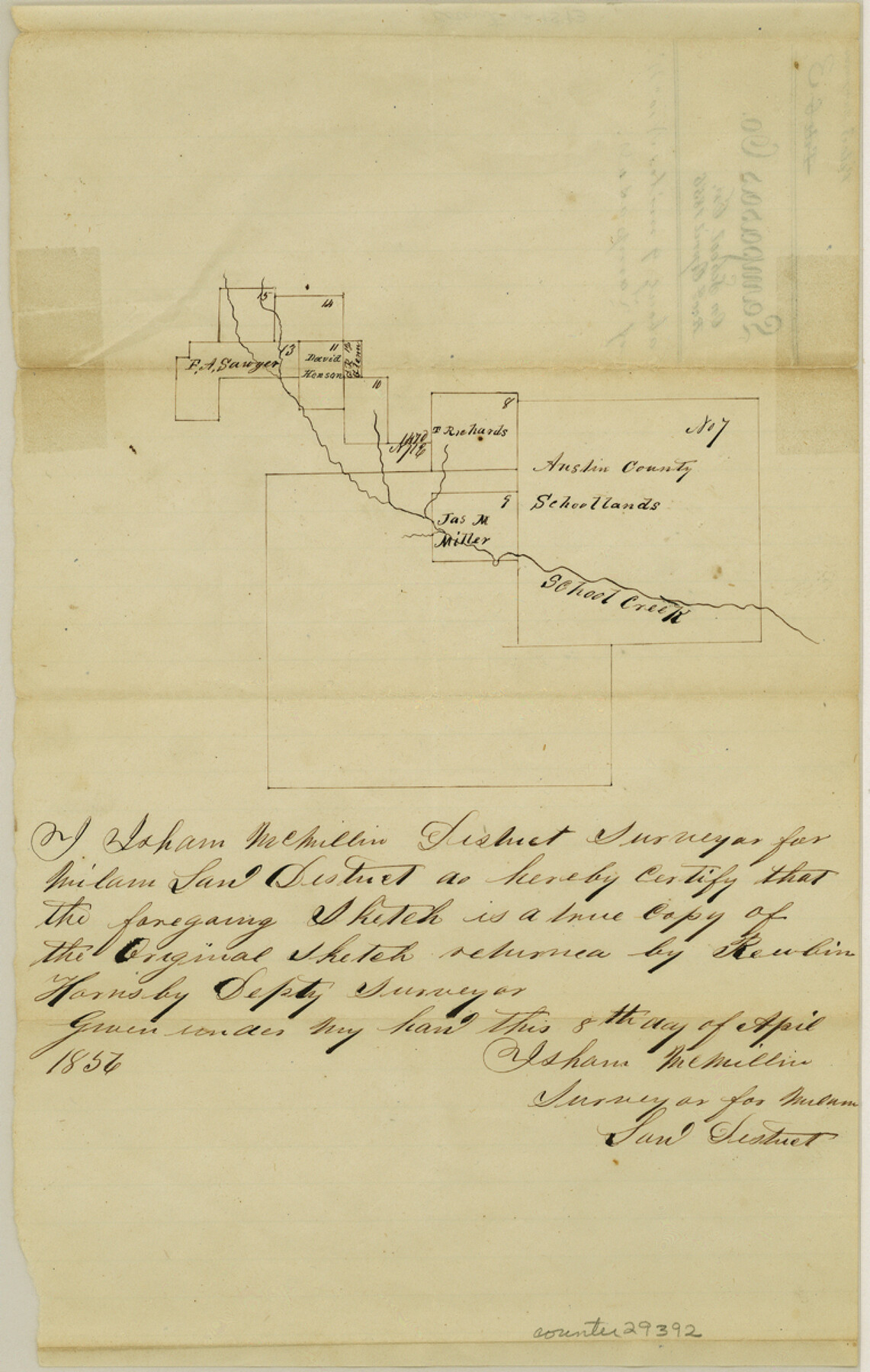
Lampasas County Sketch File 3
[Sketch of area north of Lampasas near School Creek]
-
Map/Doc
29392
-
Collection
General Map Collection
-
Object Dates
4/8/1856 (Creation Date)
-
People and Organizations
Isham McMillan (Surveyor/Engineer)
-
Counties
Lampasas
-
Subjects
Surveying Sketch File
-
Height x Width
12.1 x 7.6 inches
30.7 x 19.3 cm
-
Medium
paper, manuscript
-
Features
School Creek
School Creek
Part of: General Map Collection
Stephens County Sketch File 25

Print $35.00
- Digital $50.00
Stephens County Sketch File 25
1875
Size 11.0 x 15.9 inches
Map/Doc 37090
Connected Map of Austin's Colony

Print $20.00
- Digital $50.00
Connected Map of Austin's Colony
1892
Size 47.3 x 43.3 inches
Map/Doc 76075
Val Verde County Working Sketch 18

Print $20.00
- Digital $50.00
Val Verde County Working Sketch 18
1928
Size 31.4 x 28.3 inches
Map/Doc 72153
[Sketch for Mineral Application 24072, San Jacinto River]
![65590, [Sketch for Mineral Application 24072, San Jacinto River], General Map Collection](https://historictexasmaps.com/wmedia_w700/maps/65590.tif.jpg)
Print $20.00
- Digital $50.00
[Sketch for Mineral Application 24072, San Jacinto River]
1929
Size 40.8 x 14.7 inches
Map/Doc 65590
Presidio County Working Sketch 81

Print $20.00
- Digital $50.00
Presidio County Working Sketch 81
1967
Size 18.9 x 17.4 inches
Map/Doc 71758
Index to the following sixteen sheets, being a compleat chart of the West Indies with letters in the margin to direct the placing of the different sheets in their proper places

Print $20.00
- Digital $50.00
Index to the following sixteen sheets, being a compleat chart of the West Indies with letters in the margin to direct the placing of the different sheets in their proper places
1792
Size 21.5 x 28.6 inches
Map/Doc 96440
Sulphur River, Talco Sheet

Print $20.00
- Digital $50.00
Sulphur River, Talco Sheet
1917
Size 12.5 x 25.5 inches
Map/Doc 78336
Hemphill County Working Sketch 6

Print $20.00
- Digital $50.00
Hemphill County Working Sketch 6
1950
Size 20.3 x 27.0 inches
Map/Doc 66101
Real County Working Sketch 57

Print $20.00
- Digital $50.00
Real County Working Sketch 57
1962
Size 19.6 x 25.8 inches
Map/Doc 71949
Flight Mission No. DAG-21K, Frame 99, Matagorda County

Print $20.00
- Digital $50.00
Flight Mission No. DAG-21K, Frame 99, Matagorda County
1952
Size 17.5 x 16.3 inches
Map/Doc 86428
Flight Mission No. BRA-3M, Frame 194, Jefferson County

Print $20.00
- Digital $50.00
Flight Mission No. BRA-3M, Frame 194, Jefferson County
1953
Size 18.8 x 22.4 inches
Map/Doc 85409
Coke County Rolled Sketch 19

Print $20.00
- Digital $50.00
Coke County Rolled Sketch 19
1954
Size 18.5 x 25.8 inches
Map/Doc 5519
You may also like
Dawson County Rolled Sketch 4
Print $20.00
- Digital $50.00
Dawson County Rolled Sketch 4
Size 24.3 x 23.9 inches
Map/Doc 5690

Right of Way & Track Map Houston & Brazos Valley Ry. operated by Houston & Brazos Valley Ry. Co., Hoskins Mound Branch

Print $40.00
- Digital $50.00
Right of Way & Track Map Houston & Brazos Valley Ry. operated by Houston & Brazos Valley Ry. Co., Hoskins Mound Branch
1924
Size 25.3 x 56.4 inches
Map/Doc 64611
Reeves County Rolled Sketch N

Print $40.00
- Digital $50.00
Reeves County Rolled Sketch N
Size 44.5 x 74.7 inches
Map/Doc 9846
Flight Mission No. CRC-3R, Frame 211, Chambers County

Print $20.00
- Digital $50.00
Flight Mission No. CRC-3R, Frame 211, Chambers County
1956
Size 18.6 x 22.2 inches
Map/Doc 84866
Jefferson County Rolled Sketch 13

Print $20.00
- Digital $50.00
Jefferson County Rolled Sketch 13
Size 18.8 x 27.2 inches
Map/Doc 6385
Denton County, Texas

Print $20.00
- Digital $50.00
Denton County, Texas
1870
Size 18.6 x 22.7 inches
Map/Doc 723
Blanco County Working Sketch 44

Print $20.00
- Digital $50.00
Blanco County Working Sketch 44
2000
Size 19.5 x 35.6 inches
Map/Doc 67404
Roberts County Working Sketch 15

Print $20.00
- Digital $50.00
Roberts County Working Sketch 15
1975
Size 40.5 x 38.7 inches
Map/Doc 63541


Blanco County Working Sketch 36

Print $20.00
- Digital $50.00
Blanco County Working Sketch 36
1979
Size 23.8 x 22.0 inches
Map/Doc 67396