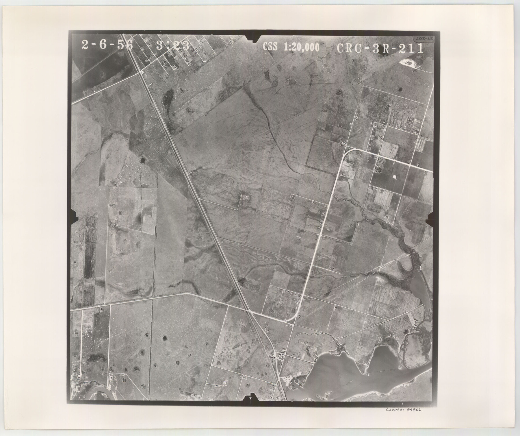
Flight Mission No. CRC-3R, Frame 211, Chambers County
CRC-3R-211
-
Map/Doc
84866
-
Collection
General Map Collection
-
Object Dates
1956/2/6 (Creation Date)
-
People and Organizations
U. S. Department of Agriculture (Publisher)
-
Counties
Chambers
-
Subjects
Aerial Photograph
-
Height x Width
18.6 x 22.2 inches
47.2 x 56.4 cm
-
Comments
Flown by Jack Ammann Photogrammetric Engineers, Inc. of San Antonio, Texas.
Part of: General Map Collection
Right of Way & Track Map, St. Louis, Brownsville & Mexico Ry. operated by St. Louis, Brownsville & Mexico Ry. Co.

Print $40.00
- Digital $50.00
Right of Way & Track Map, St. Louis, Brownsville & Mexico Ry. operated by St. Louis, Brownsville & Mexico Ry. Co.
1919
Size 25.7 x 57.1 inches
Map/Doc 64625
Trinity River, Clear Lake Sheet/East Fork of Trinity River and Pilot Grove Creek

Print $6.00
- Digital $50.00
Trinity River, Clear Lake Sheet/East Fork of Trinity River and Pilot Grove Creek
1923
Size 33.0 x 31.1 inches
Map/Doc 65194
Webb County Working Sketch 83

Print $20.00
- Digital $50.00
Webb County Working Sketch 83
1980
Size 20.7 x 34.9 inches
Map/Doc 72450
Presidio County Sketch File 69a

Print $6.00
- Digital $50.00
Presidio County Sketch File 69a
1923
Size 17.0 x 11.0 inches
Map/Doc 34664
Orange County Working Sketch 33

Print $20.00
- Digital $50.00
Orange County Working Sketch 33
1957
Size 26.1 x 18.4 inches
Map/Doc 71365
Maps & Lists Showing Prison Lands (Oil & Gas) Leased as of June 1955

Digital $50.00
Maps & Lists Showing Prison Lands (Oil & Gas) Leased as of June 1955
1934
Size 30.2 x 35.2 inches
Map/Doc 62877
Flight Mission No. BRA-8M, Frame 69, Jefferson County

Print $20.00
- Digital $50.00
Flight Mission No. BRA-8M, Frame 69, Jefferson County
1953
Size 18.6 x 22.1 inches
Map/Doc 85589
Matagorda County NRC Article 33.136 Sketch 2

Print $26.00
- Digital $50.00
Matagorda County NRC Article 33.136 Sketch 2
2005
Size 22.1 x 34.8 inches
Map/Doc 83395
Hopkins County Sketch File 6

Print $7.00
- Digital $50.00
Hopkins County Sketch File 6
1853
Size 12.4 x 8.1 inches
Map/Doc 26689
Flight Mission No. DAG-21K, Frame 108, Matagorda County

Print $20.00
- Digital $50.00
Flight Mission No. DAG-21K, Frame 108, Matagorda County
1952
Size 18.7 x 22.3 inches
Map/Doc 86436
Comanche County Working Sketch 15

Print $20.00
- Digital $50.00
Comanche County Working Sketch 15
1964
Size 20.3 x 25.5 inches
Map/Doc 68149
Houston County Sketch File 37

Print $6.00
- Digital $50.00
Houston County Sketch File 37
1846
Size 12.8 x 7.8 inches
Map/Doc 26819
You may also like
Angelina County Working Sketch 21

Print $20.00
- Digital $50.00
Angelina County Working Sketch 21
1947
Size 35.7 x 35.8 inches
Map/Doc 67102

Austin's Register of Families Vol. 1

Austin's Register of Families Vol. 1
Size 14.0 x 10.2 inches
Map/Doc 94249
Lighthouse establishment on the Atlantic and Gulf Coasts and coast signal stations

Print $20.00
- Digital $50.00
Lighthouse establishment on the Atlantic and Gulf Coasts and coast signal stations
1898
Size 25.1 x 18.3 inches
Map/Doc 73051
Subdivision of Outlots 1 and 2 in Original Townsite of Seagraves, Texas

Print $20.00
- Digital $50.00
Subdivision of Outlots 1 and 2 in Original Townsite of Seagraves, Texas
1955
Size 17.3 x 29.1 inches
Map/Doc 92688
Uvalde County Working Sketch 41

Print $20.00
- Digital $50.00
Uvalde County Working Sketch 41
1975
Size 15.6 x 27.4 inches
Map/Doc 72111
Robertson County Sketch File 7

Print $20.00
Robertson County Sketch File 7
1873
Size 16.3 x 24.0 inches
Map/Doc 12250
J.H. Clark's Report of 1861 - Boundary Between Texas and New Mexico

Print $78.00
J.H. Clark's Report of 1861 - Boundary Between Texas and New Mexico
1861
Map/Doc 81689
Sutton County Rolled Sketch 50

Print $40.00
- Digital $50.00
Sutton County Rolled Sketch 50
1950
Size 55.5 x 44.4 inches
Map/Doc 9975
Llano County Working Sketch 15

Print $20.00
- Digital $50.00
Llano County Working Sketch 15
2007
Size 46.0 x 26.2 inches
Map/Doc 87372
[Blocks O3 and O4 and Capitol Leagues in the vicinity]
![90391, [Blocks O3 and O4 and Capitol Leagues in the vicinity], Twichell Survey Records](https://historictexasmaps.com/wmedia_w700/maps/90391-1.tif.jpg)
Print $2.00
- Digital $50.00
[Blocks O3 and O4 and Capitol Leagues in the vicinity]
Size 8.4 x 10.5 inches
Map/Doc 90391
Comanche County Sketch File 9

Print $4.00
- Digital $50.00
Comanche County Sketch File 9
1859
Size 6.0 x 9.1 inches
Map/Doc 19068