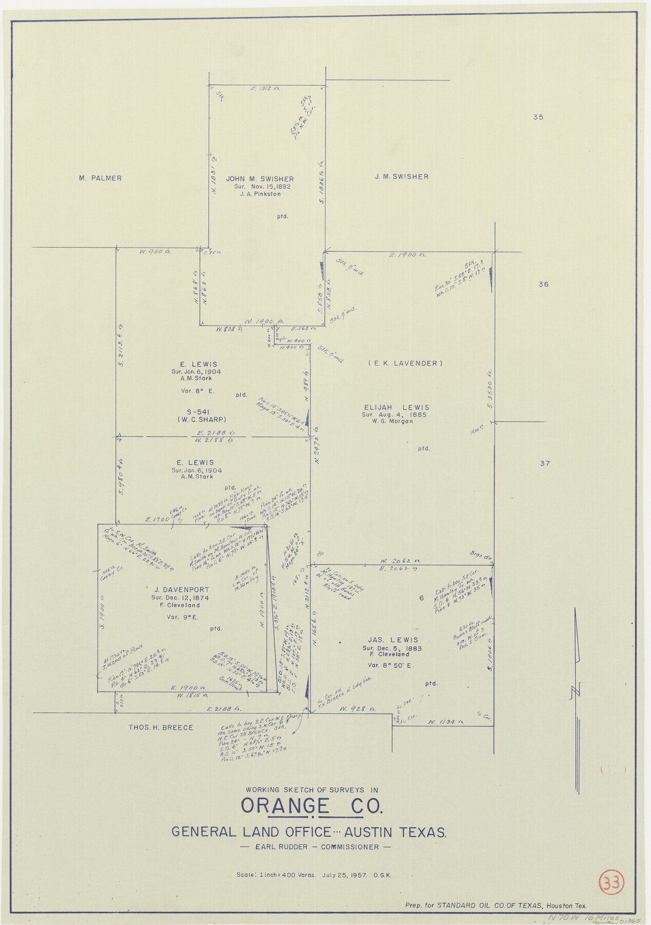
Orange County Working Sketch 33
-
Map/Doc
71365
-
Collection
General Map Collection
-
Object Dates
7/25/1957 (Creation Date)
-
People and Organizations
Otto G. Kurio (Draftsman)
-
Counties
Orange
-
Subjects
Surveying Working Sketch
-
Height x Width
26.1 x 18.4 inches
66.3 x 46.7 cm
-
Scale
1" = 400 varas
Part of: General Map Collection
Map of Upton County

Print $20.00
- Digital $50.00
Map of Upton County
1889
Size 23.4 x 21.4 inches
Map/Doc 4104
Flight Mission No. CGI-4N, Frame 26, Cameron County

Print $20.00
- Digital $50.00
Flight Mission No. CGI-4N, Frame 26, Cameron County
1954
Size 18.8 x 22.3 inches
Map/Doc 84659
San Augustine County Sketch File 2

Print $4.00
San Augustine County Sketch File 2
1846
Size 8.2 x 8.2 inches
Map/Doc 35633
Montgomery County Working Sketch 30

Print $20.00
- Digital $50.00
Montgomery County Working Sketch 30
1946
Size 30.7 x 34.8 inches
Map/Doc 71137
Flight Mission No. CUG-1P, Frame 163, Kleberg County

Print $20.00
- Digital $50.00
Flight Mission No. CUG-1P, Frame 163, Kleberg County
1956
Size 18.6 x 22.2 inches
Map/Doc 86170
Starr County Rolled Sketch 28

Print $20.00
- Digital $50.00
Starr County Rolled Sketch 28
1941
Size 29.0 x 20.6 inches
Map/Doc 7811
Brewster County Rolled Sketch 114

Print $20.00
- Digital $50.00
Brewster County Rolled Sketch 114
1964
Size 11.5 x 18.2 inches
Map/Doc 5286
El Paso County Rolled Sketch 46A

Print $20.00
- Digital $50.00
El Paso County Rolled Sketch 46A
1937
Size 35.1 x 30.2 inches
Map/Doc 5833
Pecos County Rolled Sketch 173

Print $20.00
- Digital $50.00
Pecos County Rolled Sketch 173
Size 32.2 x 35.6 inches
Map/Doc 9751
Travis County Rolled Sketch 56

Print $20.00
- Digital $50.00
Travis County Rolled Sketch 56
1885
Size 16.7 x 23.2 inches
Map/Doc 8047
Erath County Sketch File 1

Print $4.00
- Digital $50.00
Erath County Sketch File 1
Size 3.9 x 8.1 inches
Map/Doc 22253
Harrison County

Print $20.00
- Digital $50.00
Harrison County
1920
Size 43.0 x 40.0 inches
Map/Doc 77305
You may also like
Sutton County Rolled Sketch 45

Print $20.00
- Digital $50.00
Sutton County Rolled Sketch 45
Size 39.1 x 47.2 inches
Map/Doc 9974
Kaufman County Sketch File 1

Print $4.00
- Digital $50.00
Kaufman County Sketch File 1
Size 8.3 x 8.3 inches
Map/Doc 28624
Brewster County Sketch File FN-31

Print $4.00
- Digital $50.00
Brewster County Sketch File FN-31
1975
Size 11.3 x 8.8 inches
Map/Doc 15852
Tarrant County Working Sketch 7

Print $40.00
- Digital $50.00
Tarrant County Working Sketch 7
1981
Size 18.9 x 54.3 inches
Map/Doc 62424
Blanco County Rolled Sketch 13

Print $20.00
- Digital $50.00
Blanco County Rolled Sketch 13
Size 14.2 x 28.9 inches
Map/Doc 5149
Working Sketch Compiled from Original Field Notes Irion County, Texas

Print $20.00
- Digital $50.00
Working Sketch Compiled from Original Field Notes Irion County, Texas
Size 19.4 x 19.5 inches
Map/Doc 92187
Sketch Showing Section 3, Block JW, Subdivided to Show Quantity East of Texas Sections

Print $40.00
- Digital $50.00
Sketch Showing Section 3, Block JW, Subdivided to Show Quantity East of Texas Sections
Size 5.8 x 49.9 inches
Map/Doc 91303
[Corner of Crosby, Lubbock, Lynn and Garza Counties]
![90905, [Corner of Crosby, Lubbock, Lynn and Garza Counties], Twichell Survey Records](https://historictexasmaps.com/wmedia_w700/maps/90905-1.tif.jpg)
Print $20.00
- Digital $50.00
[Corner of Crosby, Lubbock, Lynn and Garza Counties]
Size 36.0 x 22.8 inches
Map/Doc 90905
Flight Mission No. CRE-1R, Frame 67, Jackson County

Print $20.00
- Digital $50.00
Flight Mission No. CRE-1R, Frame 67, Jackson County
1956
Size 18.7 x 22.3 inches
Map/Doc 85330
The Republic County of Bowie. January 16, 1843

Print $20.00
The Republic County of Bowie. January 16, 1843
2020
Size 19.5 x 21.7 inches
Map/Doc 96106
Schleicher County Sketch File 11

Print $20.00
- Digital $50.00
Schleicher County Sketch File 11
1912
Size 21.5 x 30.5 inches
Map/Doc 12298
Upton County Rolled Sketch 53

Print $20.00
- Digital $50.00
Upton County Rolled Sketch 53
Size 26.9 x 30.8 inches
Map/Doc 8088