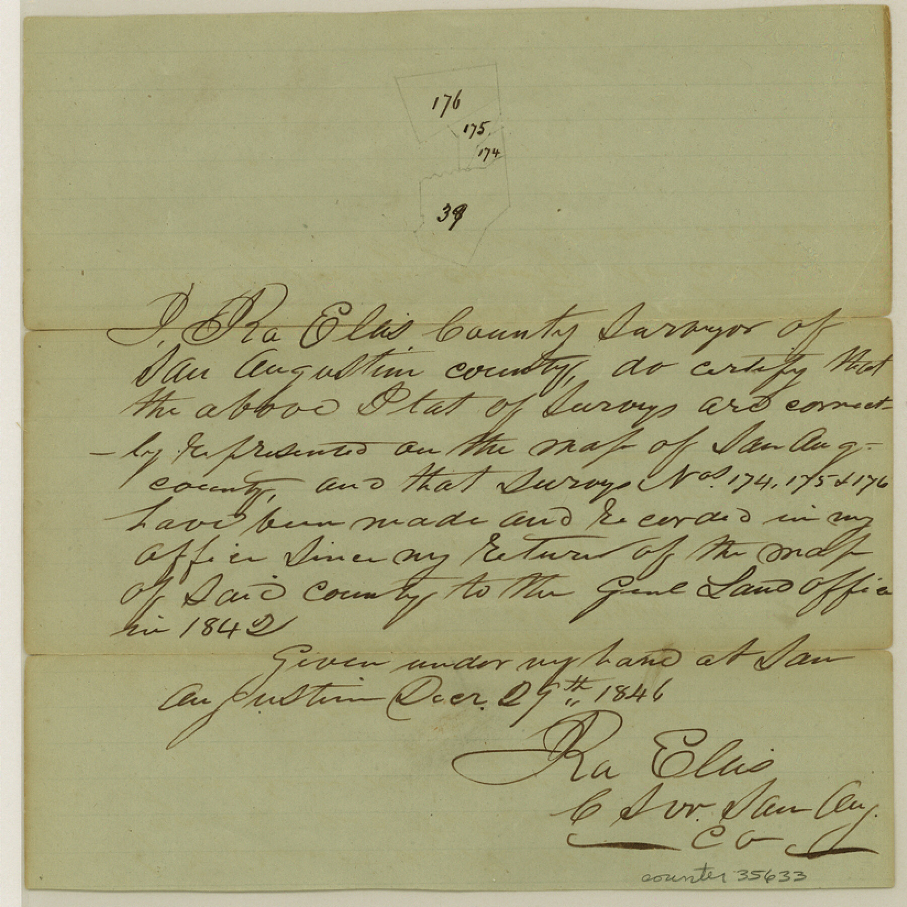
San Augustine County Sketch File 2
[Sketch of surveys near Price Creek and Blue Creek in the northwest corner of the county]
- 
                          Map/Doc35633
- 
                            CollectionGeneral Map Collection
- 
                            Object Dates12/29/1846 (Creation Date)
- 
                            People and OrganizationsIra Ellis (Surveyor/Engineer)
- 
                            CountiesSan Augustine
- 
                            SubjectsSurveying Sketch File
- 
                            Height x Width8.2 x 8.2 inches20.8 x 20.8 cm
- 
                            Mediumpaper, manuscript
Part of: General Map Collection
            Flight Mission No. DAG-26K, Frame 59, Matagorda County


                                            Print $20.00                    
                                             -                         Digital $50.00                                    
                Flight Mission No. DAG-26K, Frame 59, Matagorda County
1953
Size 18.5 x 22.3 inches
                                Map/Doc 86579
            
            DeWitt County Sketch File 8


                                            Print $4.00                    
                                             -                         Digital $50.00                                    
                DeWitt County Sketch File 8
1876
Size 8.5 x 5.2 inches
                                Map/Doc 20818
            
            Sterling County Rolled Sketch 35


                                            Print $20.00                    
                                             -                         Digital $50.00                                    
                Sterling County Rolled Sketch 35
1960
Size 20.8 x 21.8 inches
                                Map/Doc 7859
            
            [Subdivision of Nueces Bay and list of Court Decrees]
            
                                    ![2086, [Subdivision of Nueces Bay and list of Court Decrees], General Map Collection](https://historictexasmaps.com/wmedia_w700/maps/2086-1.tif.jpg) 


    ![2086, [Subdivision of Nueces Bay and list of Court Decrees], General Map Collection](https://historictexasmaps.com/wmedia_w700/maps/2086-1.tif.jpg) 
                                
            
                                            Print $40.00                    
                                             -                         Digital $50.00                                    
                [Subdivision of Nueces Bay and list of Court Decrees]
1940
Size 34.2 x 48.8 inches
                                Map/Doc 2086
            
            [Maps of surveys in Reeves & Culberson Cos]
            
                                    ![61134, [Maps of surveys in Reeves & Culberson Cos], General Map Collection](https://historictexasmaps.com/wmedia_w700/maps/61134.tif.jpg) 


    ![61134, [Maps of surveys in Reeves & Culberson Cos], General Map Collection](https://historictexasmaps.com/wmedia_w700/maps/61134.tif.jpg) 
                                
            
                                            Print $20.00                    
                                             -                         Digital $50.00                                    
                [Maps of surveys in Reeves & Culberson Cos]
1937
Size 30.7 x 24.9 inches
                                Map/Doc 61134
            
            Andrews County Rolled Sketch 18


                                            Print $20.00                    
                                             -                         Digital $50.00                                    
                Andrews County Rolled Sketch 18
1942
Size 26.0 x 31.3 inches
                                Map/Doc 8394
            
            Potter County


                                            Print $20.00                    
                                             -                         Digital $50.00                                    
                Potter County
1960
Size 42.5 x 34.6 inches
                                Map/Doc 73264
            
            Real County Working Sketch 64


                                            Print $20.00                    
                                             -                         Digital $50.00                                    
                Real County Working Sketch 64
1968
Size 31.4 x 30.0 inches
                                Map/Doc 71956
            
            Dimmit County Rolled Sketch 19


                                            Print $20.00                    
                                             -                         Digital $50.00                                    
                Dimmit County Rolled Sketch 19
1990
Size 45.4 x 41.7 inches
                                Map/Doc 8799
            
            Midland County Rolled Sketch 12


                                            Print $40.00                    
                                             -                         Digital $50.00                                    
                Midland County Rolled Sketch 12
Size 97.0 x 42.6 inches
                                Map/Doc 9520
            
            Refugio County Aerial Photograph Index Sheet 1


                                            Print $20.00                    
                                             -                         Digital $50.00                                    
                Refugio County Aerial Photograph Index Sheet 1
1957
Size 23.1 x 18.8 inches
                                Map/Doc 83742
            
            Texas City Channel, Texas, Channel and Turning Basin Dredging - Sheet 1


                                            Print $20.00                    
                                             -                         Digital $50.00                                    
                Texas City Channel, Texas, Channel and Turning Basin Dredging - Sheet 1
1958
Size 29.3 x 40.8 inches
                                Map/Doc 61831
            You may also like
            Jefferson County Rolled Sketch 60


                                            Print $20.00                    
                                             -                         Digital $50.00                                    
                Jefferson County Rolled Sketch 60
1885
Size 34.0 x 35.9 inches
                                Map/Doc 9316
            
            Blanco County Working Sketch Graphic Index


                                            Print $20.00                    
                                             -                         Digital $50.00                                    
                Blanco County Working Sketch Graphic Index
1965
Size 43.1 x 33.6 inches
                                Map/Doc 76467
            
            Duval County Boundary File 1a


                                            Print $18.00                    
                                             -                         Digital $50.00                                    
                Duval County Boundary File 1a
Size 12.8 x 8.4 inches
                                Map/Doc 52670
            
            Nueces County Rolled Sketch 55


                                            Print $20.00                    
                                             -                         Digital $50.00                                    
                Nueces County Rolled Sketch 55
1978
Size 25.7 x 37.5 inches
                                Map/Doc 6892
            
            Hockley County


                                            Print $20.00                    
                                             -                         Digital $50.00                                    
                Hockley County
1954
Size 42.9 x 38.9 inches
                                Map/Doc 1856
            
            Reagan County


                                            Print $20.00                    
                                             -                         Digital $50.00                                    
                Reagan County
1903
Size 45.6 x 36.2 inches
                                Map/Doc 16794
            
            [Sketch of Surveys south of League 153]
            
                                    ![90438, [Sketch of Surveys south of League 153], Twichell Survey Records](https://historictexasmaps.com/wmedia_w700/maps/90438-1.tif.jpg) 


    ![90438, [Sketch of Surveys south of League 153], Twichell Survey Records](https://historictexasmaps.com/wmedia_w700/maps/90438-1.tif.jpg) 
                                
            
                                            Print $2.00                    
                                             -                         Digital $50.00                                    
                [Sketch of Surveys south of League 153]
Size 9.1 x 5.9 inches
                                Map/Doc 90438
            
            [Surveys along the Trinity River and below]
            
                                    ![101, [Surveys along the Trinity River and below], General Map Collection](https://historictexasmaps.com/wmedia_w700/maps/101.tif.jpg) 


    ![101, [Surveys along the Trinity River and below], General Map Collection](https://historictexasmaps.com/wmedia_w700/maps/101.tif.jpg) 
                                
            
                                            Print $20.00                    
                                             -                         Digital $50.00                                    
                [Surveys along the Trinity River and below]
1840
Size 22.6 x 17.6 inches
                                Map/Doc 101
            
            Montgomery County Working Sketch 48


                                            Print $20.00                    
                                             -                         Digital $50.00                                    
                Montgomery County Working Sketch 48
1958
Size 24.4 x 32.1 inches
                                Map/Doc 71155
            
            United States Bathymetric and Fishing Maps including Topographic/Bathymetric Maps


                                            Print $40.00                    
                                             -                         Digital $50.00                                    
                United States Bathymetric and Fishing Maps including Topographic/Bathymetric Maps
1992
Size 21.5 x 54.9 inches
                                Map/Doc 76128
            
            Williamson County


                                            Print $40.00                    
                                             -                         Digital $50.00                                    
                Williamson County
1888
Size 39.3 x 57.1 inches
                                Map/Doc 16929
            
            Cottle County Sketch File AA1


                                            Print $95.00                    
                                             -                         Digital $50.00                                    
                Cottle County Sketch File AA1
1895
Size 9.4 x 4.2 inches
                                Map/Doc 19398
            