Fisher County Sketch File 15a
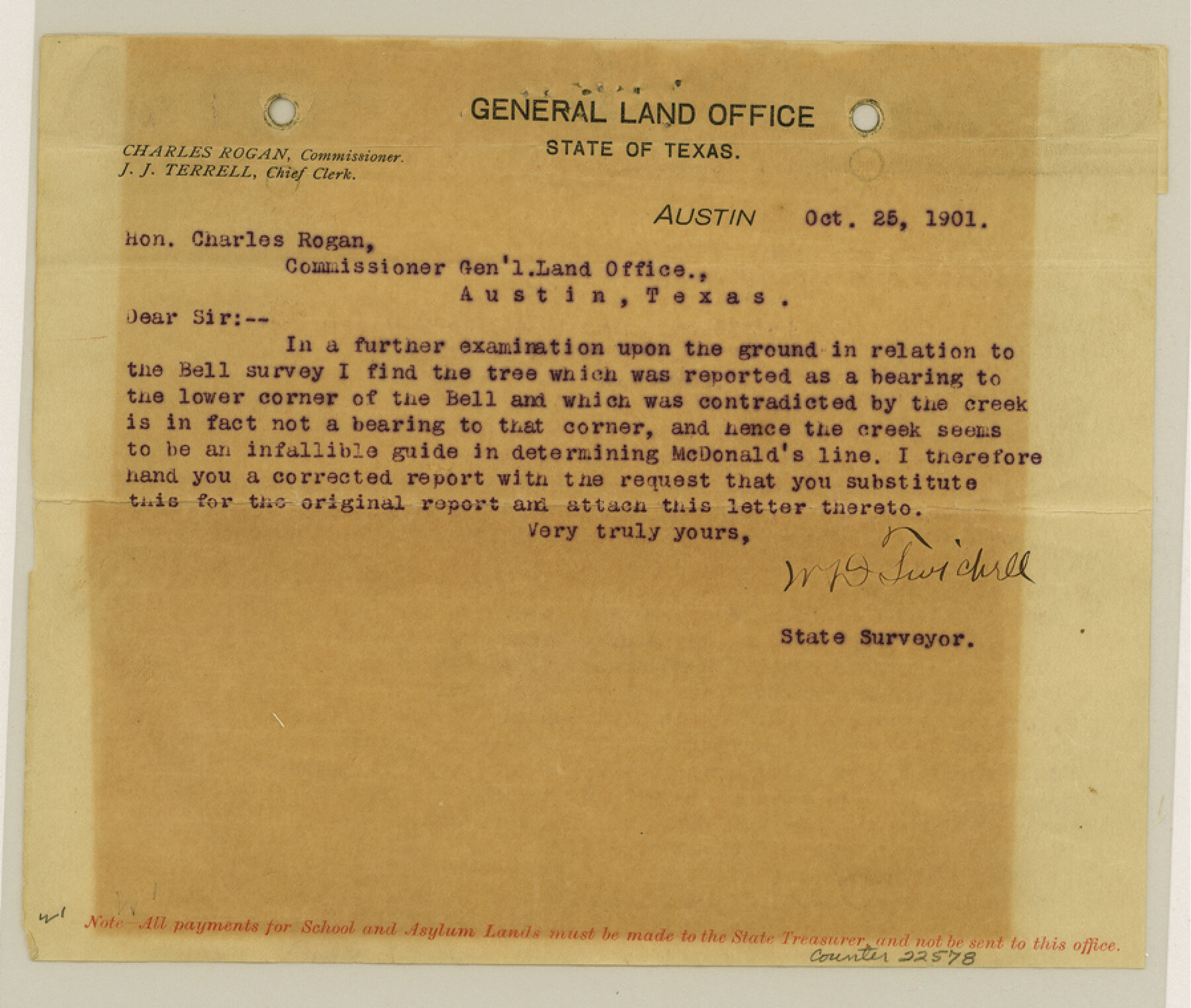
[Report of State Surveyor W. D. Twichell on resurvey of Geo. W. Lawrence, R. H. Hibbett, Burdett, Cosby and other surveys]
-
Map/Doc
22578
-
Collection
General Map Collection
-
Object Dates
1901/10/25 (Creation Date)
1901/10/25 (File Date)
-
People and Organizations
W.D. Twichell (Surveyor/Engineer)
-
Counties
Fisher
-
Subjects
Surveying Sketch File
-
Height x Width
7.6 x 9.0 inches
19.3 x 22.9 cm
-
Medium
paper, print
-
Features
Elm Fork of Brazos River
Brazos River
Part of: General Map Collection
Public Land on Mustang Island, Nueces County

Print $20.00
- Digital $50.00
Public Land on Mustang Island, Nueces County
1910
Size 17.0 x 17.5 inches
Map/Doc 93362
El Nuevo Mexico y Tierras Adyacentes Mapa Levantado para la demarcacion de los Limites de los Dominios Españoles y de los Estados Unidos

El Nuevo Mexico y Tierras Adyacentes Mapa Levantado para la demarcacion de los Limites de los Dominios Españoles y de los Estados Unidos
1811
Size 27.9 x 36.6 inches
Map/Doc 97483
Newton County Sketch File 5

Print $8.00
- Digital $50.00
Newton County Sketch File 5
Size 8.2 x 12.8 inches
Map/Doc 32368
Tyler County Sketch File 6

Print $6.00
- Digital $50.00
Tyler County Sketch File 6
1848
Size 6.0 x 7.1 inches
Map/Doc 38630
San Augustine County Rolled Sketch 1

Print $20.00
- Digital $50.00
San Augustine County Rolled Sketch 1
1946
Size 19.1 x 30.4 inches
Map/Doc 7553
Cameron County Working Sketch Graphic Index

Print $20.00
- Digital $50.00
Cameron County Working Sketch Graphic Index
1976
Size 32.0 x 39.4 inches
Map/Doc 76486
DeWitt County Sketch File 9

Print $22.00
- Digital $50.00
DeWitt County Sketch File 9
1878
Size 5.6 x 5.9 inches
Map/Doc 20820
Young County Working Sketch 1

Print $20.00
- Digital $50.00
Young County Working Sketch 1
1960
Size 31.1 x 41.9 inches
Map/Doc 62024
Intracoastal Waterway in Texas - Corpus Christi to Point Isabel including Arroyo Colorado to Mo. Pac. R.R. Bridge Near Harlingen

Print $20.00
- Digital $50.00
Intracoastal Waterway in Texas - Corpus Christi to Point Isabel including Arroyo Colorado to Mo. Pac. R.R. Bridge Near Harlingen
1933
Size 28.1 x 40.9 inches
Map/Doc 61851
[Topographical Map showing part of Miller Day Ranch in Southwest Part of Coleman County]
![81515, [Topographical Map showing part of Miller Day Ranch in Southwest Part of Coleman County], General Map Collection](https://historictexasmaps.com/wmedia_w700/maps/81515.tif.jpg)
Print $3.00
- Digital $50.00
[Topographical Map showing part of Miller Day Ranch in Southwest Part of Coleman County]
Size 11.3 x 17.3 inches
Map/Doc 81515
Haskell County Working Sketch 6

Print $20.00
- Digital $50.00
Haskell County Working Sketch 6
1949
Size 18.9 x 16.4 inches
Map/Doc 66064
Garza County Sketch File 4a

Print $4.00
- Digital $50.00
Garza County Sketch File 4a
1883
Size 14.2 x 8.8 inches
Map/Doc 24048
You may also like
Leon County Rolled Sketch 6

Print $20.00
- Digital $50.00
Leon County Rolled Sketch 6
1951
Size 31.7 x 37.1 inches
Map/Doc 6596
Kenedy County Working Sketch 2b

Print $20.00
- Digital $50.00
Kenedy County Working Sketch 2b
1911
Size 17.7 x 33.3 inches
Map/Doc 70004
Current Miscellaneous File 84

Print $10.00
- Digital $50.00
Current Miscellaneous File 84
1954
Size 11.2 x 8.8 inches
Map/Doc 74231
Cooke County Working Sketch 14

Print $40.00
- Digital $50.00
Cooke County Working Sketch 14
1944
Size 34.1 x 49.7 inches
Map/Doc 68251
Bell County Working Sketch 20

Print $20.00
- Digital $50.00
Bell County Working Sketch 20
1996
Size 39.5 x 34.7 inches
Map/Doc 67360
Brazoria County Rolled Sketch 36

Print $20.00
- Digital $50.00
Brazoria County Rolled Sketch 36
Size 18.5 x 25.0 inches
Map/Doc 5172
Lavaca County

Print $40.00
- Digital $50.00
Lavaca County
1946
Size 52.6 x 44.1 inches
Map/Doc 95566
Presidio County Sketch File 80

Print $23.00
- Digital $50.00
Presidio County Sketch File 80
1948
Size 9.5 x 20.3 inches
Map/Doc 34709
[St. L. S-W. Ry. of Texas Map of Lufkin Branch in Angelina County, Texas]
![64560, [St. L. S-W. Ry. of Texas Map of Lufkin Branch in Angelina County, Texas], General Map Collection](https://historictexasmaps.com/wmedia_w700/maps/64560-1.tif.jpg)
Print $40.00
- Digital $50.00
[St. L. S-W. Ry. of Texas Map of Lufkin Branch in Angelina County, Texas]
1913
Size 25.7 x 121.3 inches
Map/Doc 64560
DeWitt County Boundary File 25 1/2

Print $34.00
- Digital $50.00
DeWitt County Boundary File 25 1/2
Size 8.5 x 4.0 inches
Map/Doc 52522
[I. Killough and Hiram Cates surveys and vicinity]
![91851, [I. Killough and Hiram Cates surveys and vicinity], Twichell Survey Records](https://historictexasmaps.com/wmedia_w700/maps/91851-1.tif.jpg)
Print $20.00
- Digital $50.00
[I. Killough and Hiram Cates surveys and vicinity]
Size 27.5 x 9.2 inches
Map/Doc 91851
Swisher County Sketch File 19

Print $16.00
- Digital $50.00
Swisher County Sketch File 19
1913
Size 10.0 x 6.5 inches
Map/Doc 37662