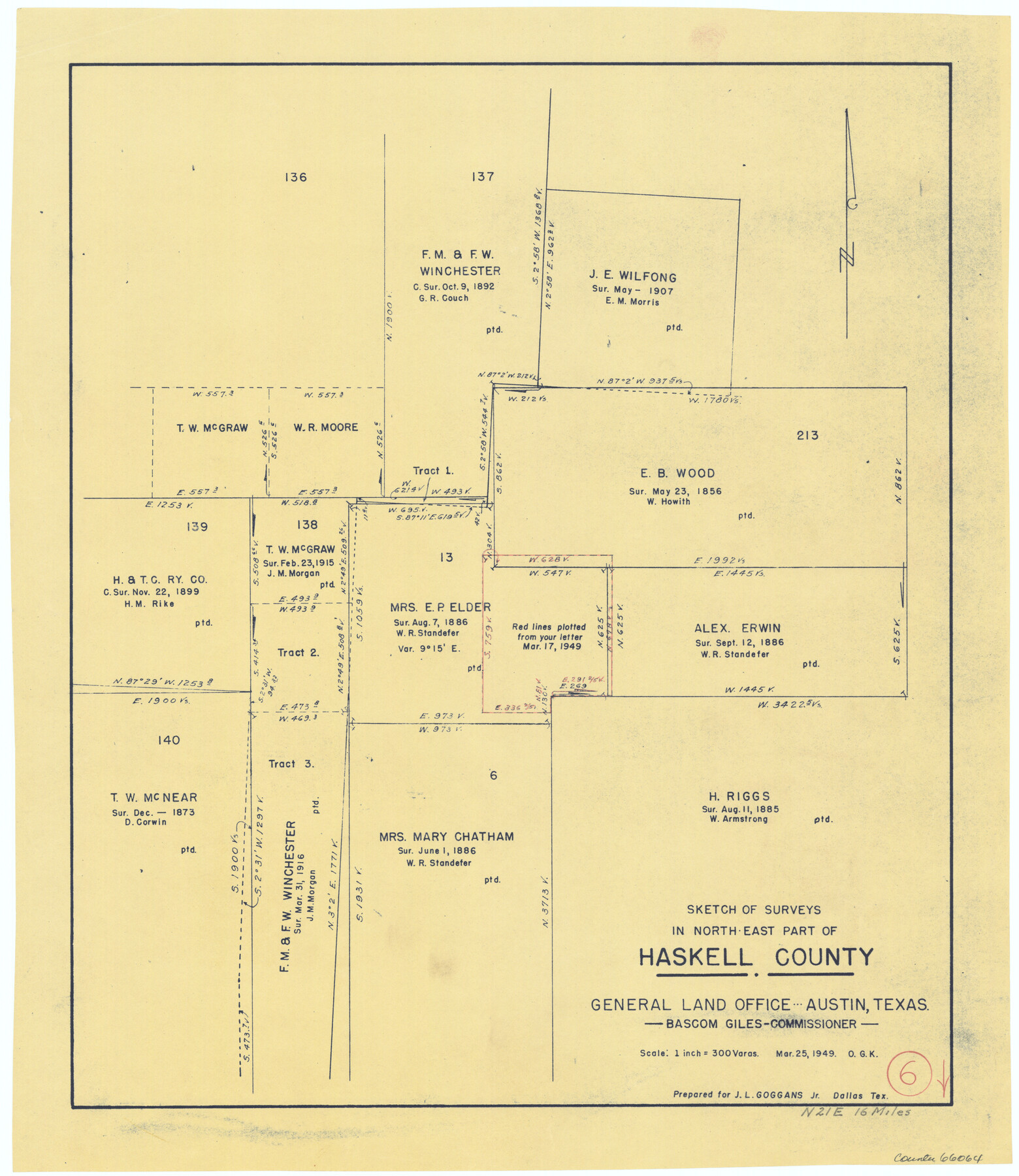
Haskell County Working Sketch 6
-
Map/Doc
66064
-
Collection
General Map Collection
-
Object Dates
3/25/1949 (Creation Date)
-
People and Organizations
Otto G. Kurio (Draftsman)
-
Counties
Haskell
-
Subjects
Surveying Working Sketch
-
Height x Width
18.9 x 16.4 inches
48.0 x 41.7 cm
-
Scale
1" = 300 varas
Part of: General Map Collection
In the Supreme Court of the United States The State of Oklahoma, Complainant vs. The State of Texas, Defendant, The United States of America, Intervener - 1921

Print $20.00
- Digital $50.00
In the Supreme Court of the United States The State of Oklahoma, Complainant vs. The State of Texas, Defendant, The United States of America, Intervener - 1921
1921
Size 24.4 x 32.4 inches
Map/Doc 75128
[Surveys along Gilleland and Wilbarger Creek in the Travis District]
![111, [Surveys along Gilleland and Wilbarger Creek in the Travis District], General Map Collection](https://historictexasmaps.com/wmedia_w700/maps/111.tif.jpg)
Print $2.00
- Digital $50.00
[Surveys along Gilleland and Wilbarger Creek in the Travis District]
1841
Size 8.1 x 11.2 inches
Map/Doc 111
Flight Mission No. DCL-7C, Frame 31, Kenedy County

Print $20.00
- Digital $50.00
Flight Mission No. DCL-7C, Frame 31, Kenedy County
1943
Size 15.4 x 15.2 inches
Map/Doc 86023
Chambers County Working Sketch 22

Print $20.00
- Digital $50.00
Chambers County Working Sketch 22
1978
Size 29.2 x 35.7 inches
Map/Doc 68005

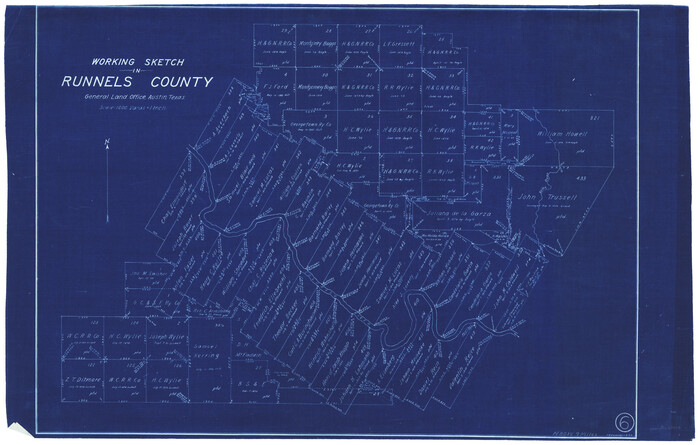
Runnels County Working Sketch 6
Print $20.00
- Digital $50.00
Runnels County Working Sketch 6
1907
Size 19.5 x 31.0 inches
Map/Doc 63602
Brewster County Working Sketch 78

Print $20.00
- Digital $50.00
Brewster County Working Sketch 78
1970
Size 31.6 x 44.3 inches
Map/Doc 67678
Flight Mission No. DQN-1K, Frame 136, Calhoun County

Print $20.00
- Digital $50.00
Flight Mission No. DQN-1K, Frame 136, Calhoun County
1953
Size 18.5 x 22.3 inches
Map/Doc 84199
Flight Mission No. CUI-1H, Frame 141, Milam County

Print $20.00
- Digital $50.00
Flight Mission No. CUI-1H, Frame 141, Milam County
1951
Size 18.4 x 22.3 inches
Map/Doc 86607
Right of Way and Track Map Houston & Texas Central R.R. operated by the T. & N.O. R.R. Co., Austin Branch

Print $40.00
- Digital $50.00
Right of Way and Track Map Houston & Texas Central R.R. operated by the T. & N.O. R.R. Co., Austin Branch
1918
Size 25.8 x 58.2 inches
Map/Doc 64554
Hansford County Sketch File 5

Print $20.00
- Digital $50.00
Hansford County Sketch File 5
1926
Size 19.0 x 23.0 inches
Map/Doc 11621
Comanche County Milam Land District

Print $20.00
- Digital $50.00
Comanche County Milam Land District
1876
Size 22.1 x 23.0 inches
Map/Doc 3433
You may also like
A general map of Great Britain and Ireland with part of Holland, Flanders, France & agreable to modern history

Print $20.00
A general map of Great Britain and Ireland with part of Holland, Flanders, France & agreable to modern history
1750
Size 21.6 x 25.7 inches
Map/Doc 97435
Medina County Rolled Sketch 19

Print $40.00
- Digital $50.00
Medina County Rolled Sketch 19
1987
Size 45.1 x 57.8 inches
Map/Doc 9508
Flight Mission No. BRA-8M, Frame 77, Jefferson County

Print $20.00
- Digital $50.00
Flight Mission No. BRA-8M, Frame 77, Jefferson County
1953
Size 15.9 x 15.7 inches
Map/Doc 85597
Titus County Sketch File 10

Print $4.00
- Digital $50.00
Titus County Sketch File 10
1871
Size 8.1 x 12.9 inches
Map/Doc 38148
Flight Mission No. CRC-1R, Frame 36, Chambers County

Print $20.00
- Digital $50.00
Flight Mission No. CRC-1R, Frame 36, Chambers County
1956
Size 18.7 x 22.3 inches
Map/Doc 84704
McMullen County Sketch File 15

Print $4.00
- Digital $50.00
McMullen County Sketch File 15
1876
Size 10.0 x 8.0 inches
Map/Doc 31363
Nolan County Working Sketch 1

Print $20.00
- Digital $50.00
Nolan County Working Sketch 1
1928
Size 17.9 x 17.5 inches
Map/Doc 71292
Reeves County Rolled Sketch 33

Print $20.00
- Digital $50.00
Reeves County Rolled Sketch 33
Size 24.9 x 36.8 inches
Map/Doc 7503
Montague County Rolled Sketch 4

Print $20.00
- Digital $50.00
Montague County Rolled Sketch 4
1940
Size 37.8 x 20.5 inches
Map/Doc 6788
El Paso County Sketch File 8

Print $40.00
- Digital $50.00
El Paso County Sketch File 8
1889
Size 16.9 x 30.5 inches
Map/Doc 11451
Cottle County Rolled Sketch 13

Print $20.00
- Digital $50.00
Cottle County Rolled Sketch 13
1976
Size 21.6 x 35.5 inches
Map/Doc 5571
Jones County Sketch File 2

Print $20.00
- Digital $50.00
Jones County Sketch File 2
1857
Size 16.8 x 21.1 inches
Map/Doc 11895