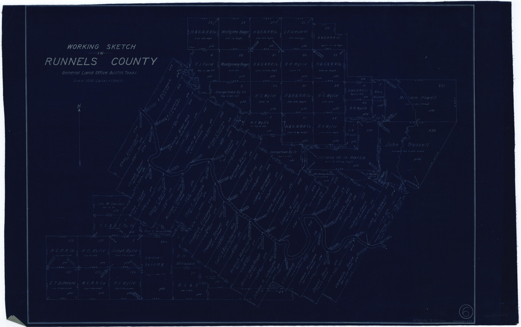
Runnels County Working Sketch 6
-
Map/Doc
63602
-
Collection
General Map Collection
-
Object Dates
1/3/1907 (Creation Date)
-
People and Organizations
Frank R. Sweeney (Draftsman)
-
Counties
Runnels
-
Subjects
Surveying Working Sketch
-
Height x Width
19.5 x 31.0 inches
49.5 x 78.7 cm
-
Scale
1" = 1000 varas
Part of: General Map Collection

Jefferson County Sketch File 15

Print $10.00
- Digital $50.00
Jefferson County Sketch File 15
1870
Size 8.6 x 7.6 inches
Map/Doc 28151
Flight Mission No. DCL-4C, Frame 147, Kenedy County

Print $20.00
- Digital $50.00
Flight Mission No. DCL-4C, Frame 147, Kenedy County
1943
Size 18.6 x 22.3 inches
Map/Doc 85825
Map of Jack County

Print $20.00
- Digital $50.00
Map of Jack County
1896
Size 43.6 x 38.9 inches
Map/Doc 66877
Presidio County Working Sketch 2

Print $20.00
- Digital $50.00
Presidio County Working Sketch 2
1907
Size 29.4 x 22.1 inches
Map/Doc 71676
Kimble County Working Sketch 7

Print $20.00
- Digital $50.00
Kimble County Working Sketch 7
1917
Size 12.6 x 16.8 inches
Map/Doc 70075
Liberty County Sketch File 53

Print $42.00
- Digital $50.00
Liberty County Sketch File 53
1900
Size 7.5 x 8.5 inches
Map/Doc 30019
Map of Parmer County

Print $20.00
- Digital $50.00
Map of Parmer County
1900
Size 47.8 x 41.3 inches
Map/Doc 16786
Historical Sketch of the Rebellion

Print $20.00
- Digital $50.00
Historical Sketch of the Rebellion
1863
Size 22.4 x 21.0 inches
Map/Doc 96618

Flight Mission No. CUG-1P, Frame 46, Kleberg County

Print $20.00
- Digital $50.00
Flight Mission No. CUG-1P, Frame 46, Kleberg County
1956
Size 18.6 x 22.2 inches
Map/Doc 86124
Edwards County Working Sketch 30

Print $20.00
- Digital $50.00
Edwards County Working Sketch 30
1947
Size 27.7 x 38.2 inches
Map/Doc 68906
You may also like
Angelina County Working Sketch 33

Print $20.00
- Digital $50.00
Angelina County Working Sketch 33
1955
Size 22.7 x 24.2 inches
Map/Doc 67116
North Sulphur River, Bartley Gin Sheet

Print $20.00
- Digital $50.00
North Sulphur River, Bartley Gin Sheet
1928
Size 21.1 x 42.5 inches
Map/Doc 65173
Right of Way & Track Map, San Antonio & Aransas Pass Railway Co.

Print $40.00
- Digital $50.00
Right of Way & Track Map, San Antonio & Aransas Pass Railway Co.
1919
Size 25.2 x 56.8 inches
Map/Doc 64218
San Patricio County Rolled Sketch 25

Print $40.00
- Digital $50.00
San Patricio County Rolled Sketch 25
1925
Size 37.2 x 54.1 inches
Map/Doc 9887

Foard County Working Sketch 5a

Print $20.00
- Digital $50.00
Foard County Working Sketch 5a
1942
Size 18.4 x 24.2 inches
Map/Doc 69195
Erath County Boundary File 1

Print $8.00
- Digital $50.00
Erath County Boundary File 1
Size 13.1 x 8.8 inches
Map/Doc 53237
Colorado County Sketch File 34

Print $86.00
- Digital $50.00
Colorado County Sketch File 34
1996
Size 14.2 x 8.8 inches
Map/Doc 18992
Mills County Working Sketch 15

Print $20.00
- Digital $50.00
Mills County Working Sketch 15
1951
Size 38.4 x 41.6 inches
Map/Doc 71045
Maps of Gulf Intracoastal Waterway, Texas - Sabine River to the Rio Grande and connecting waterways including ship channels

Print $20.00
- Digital $50.00
Maps of Gulf Intracoastal Waterway, Texas - Sabine River to the Rio Grande and connecting waterways including ship channels
1966
Size 14.5 x 22.4 inches
Map/Doc 61929
McCulloch County Rolled Sketch 11

Print $20.00
- Digital $50.00
McCulloch County Rolled Sketch 11
1992
Size 46.3 x 40.3 inches
Map/Doc 9499
Houston County Working Sketch 29

Print $20.00
- Digital $50.00
Houston County Working Sketch 29
1990
Size 23.4 x 23.1 inches
Map/Doc 66259