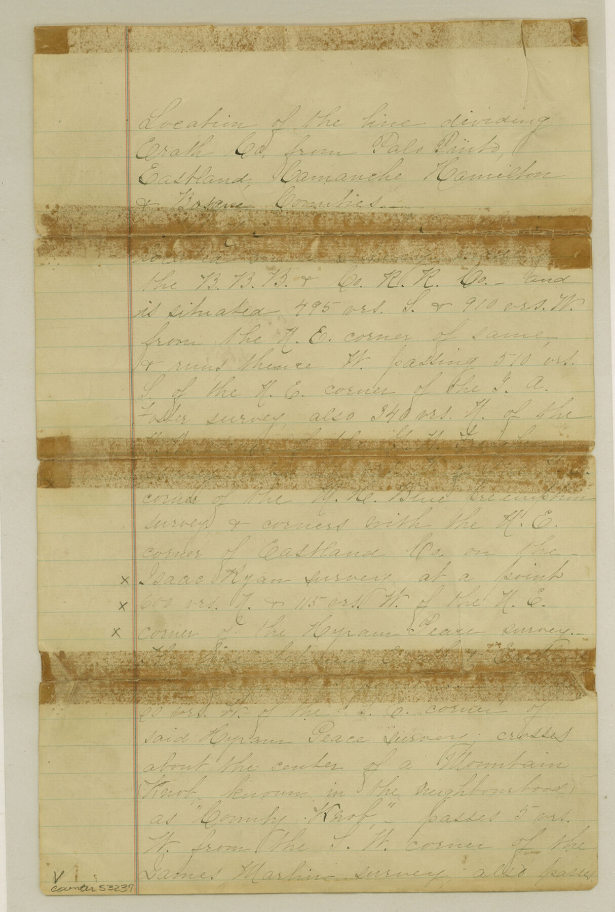
Erath County Boundary File 1
Surveyor's Certificate of Co. line
-
Map/Doc
53237
-
Collection
General Map Collection
-
Counties
Erath
-
Subjects
County Boundaries
-
Height x Width
13.1 x 8.8 inches
33.3 x 22.4 cm
Part of: General Map Collection
Walker County Working Sketch 2

Print $20.00
- Digital $50.00
Walker County Working Sketch 2
1918
Size 16.7 x 14.5 inches
Map/Doc 72282
[Right of Way & Track Map, The Texas & Pacific Ry. Co. Main Line]
![64673, [Right of Way & Track Map, The Texas & Pacific Ry. Co. Main Line], General Map Collection](https://historictexasmaps.com/wmedia_w700/maps/64673.tif.jpg)
Print $20.00
- Digital $50.00
[Right of Way & Track Map, The Texas & Pacific Ry. Co. Main Line]
Size 11.2 x 18.6 inches
Map/Doc 64673
Hamilton County Sketch File 15

Print $2.00
- Digital $50.00
Hamilton County Sketch File 15
1882
Size 8.0 x 11.8 inches
Map/Doc 24941
Bowie County Sketch File 8a

Print $4.00
- Digital $50.00
Bowie County Sketch File 8a
1927
Size 10.6 x 8.6 inches
Map/Doc 14873
Padre Island National Seashore

Print $4.00
- Digital $50.00
Padre Island National Seashore
Size 16.0 x 22.1 inches
Map/Doc 60528
Calhoun County Rolled Sketch 14

Print $20.00
- Digital $50.00
Calhoun County Rolled Sketch 14
Size 22.2 x 40.6 inches
Map/Doc 5369
McMullen County Working Sketch 12

Print $20.00
- Digital $50.00
McMullen County Working Sketch 12
1938
Size 23.4 x 26.8 inches
Map/Doc 70713
San Patricio County Working Sketch 13

Print $20.00
- Digital $50.00
San Patricio County Working Sketch 13
1949
Size 38.8 x 38.6 inches
Map/Doc 63775
Controlled Mosaic by Jack Amman Photogrammetric Engineers, Inc - Sheet 42

Print $20.00
- Digital $50.00
Controlled Mosaic by Jack Amman Photogrammetric Engineers, Inc - Sheet 42
1954
Size 20.0 x 24.0 inches
Map/Doc 83499
Crosby County Rolled Sketch D

Print $20.00
- Digital $50.00
Crosby County Rolled Sketch D
Size 23.9 x 23.6 inches
Map/Doc 5643

Flight Mission No. DAG-21K, Frame 89, Matagorda County

Print $20.00
- Digital $50.00
Flight Mission No. DAG-21K, Frame 89, Matagorda County
1952
Size 18.5 x 22.3 inches
Map/Doc 86418
You may also like
Map of the Recognised Line M. EL. P. & P. R. R. from East Line of Bexar Land District to El Paso

Print $20.00
- Digital $50.00
Map of the Recognised Line M. EL. P. & P. R. R. from East Line of Bexar Land District to El Paso
1857
Size 7.5 x 41.8 inches
Map/Doc 2218
Flight Mission No. DCL-7C, Frame 71, Kenedy County

Print $20.00
- Digital $50.00
Flight Mission No. DCL-7C, Frame 71, Kenedy County
1943
Size 15.5 x 15.1 inches
Map/Doc 86057
Atascosa County Sketch File 12

Print $4.00
- Digital $50.00
Atascosa County Sketch File 12
1862
Size 14.4 x 8.3 inches
Map/Doc 13769
Upton County Working Sketch 50

Print $20.00
- Digital $50.00
Upton County Working Sketch 50
1980
Size 19.5 x 21.4 inches
Map/Doc 69547
Brewster County Working Sketch 105

Print $40.00
- Digital $50.00
Brewster County Working Sketch 105
1980
Size 42.5 x 77.6 inches
Map/Doc 67705
Smith County Working Sketch 2

Print $20.00
- Digital $50.00
Smith County Working Sketch 2
Size 16.3 x 13.1 inches
Map/Doc 63887
Oyster Creek, Texas showing connection with Brazos River & Oyster Bay by the Galveston & Brazos Canal for a Light Draft Navigation

Print $40.00
- Digital $50.00
Oyster Creek, Texas showing connection with Brazos River & Oyster Bay by the Galveston & Brazos Canal for a Light Draft Navigation
Size 18.0 x 52.9 inches
Map/Doc 96562
Flight Mission No. BRA-7M, Frame 139, Jefferson County

Print $20.00
- Digital $50.00
Flight Mission No. BRA-7M, Frame 139, Jefferson County
1953
Size 18.7 x 22.4 inches
Map/Doc 85533
Foard County Sketch File 18

Print $6.00
- Digital $50.00
Foard County Sketch File 18
1888
Size 13.0 x 8.5 inches
Map/Doc 22834
General Highway Map, Dickens County, Texas

Print $20.00
General Highway Map, Dickens County, Texas
1940
Size 18.3 x 25.3 inches
Map/Doc 79076
Goliad Station Map, Galveston, Harrisburg & San Antonio Ry. operated by the T. & N. O. R.R. Co.

Print $40.00
- Digital $50.00
Goliad Station Map, Galveston, Harrisburg & San Antonio Ry. operated by the T. & N. O. R.R. Co.
1918
Size 24.7 x 55.8 inches
Map/Doc 76161
Nueces County NRC Article 33.136 Sketch 19

Print $38.00
- Digital $50.00
Nueces County NRC Article 33.136 Sketch 19
2015
Size 35.0 x 22.0 inches
Map/Doc 94767