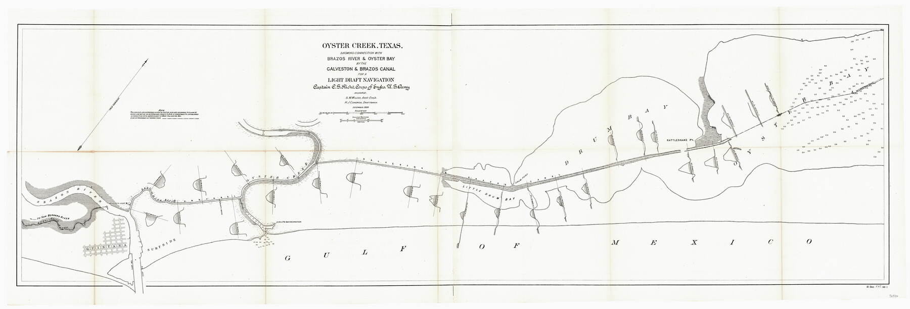
Oyster Creek, Texas showing connection with Brazos River & Oyster Bay by the Galveston & Brazos Canal for a Light Draft Navigation
-
Map/Doc
96562
-
Collection
General Map Collection
-
Object Dates
1899 (Publication Date)
-
People and Organizations
U.S. Army Corps of Engineers (Publisher)
Mark Lambert (Donor)
H.J. Condron (Draftsman)
C.S. Riche (Surveyor/Engineer)
S.M. Wilcox (Surveyor/Engineer)
-
Subjects
Nautical Charts River Surveys
-
Height x Width
18.0 x 52.9 inches
45.7 x 134.4 cm
-
Medium
paper, etching/engraving/lithograph
-
Comments
Donated by Mark Lambert
Part of: General Map Collection
Texas and part of Mexico & the United States, showing the route of the first Santa Fe Expedition

Print $20.00
- Digital $50.00
Texas and part of Mexico & the United States, showing the route of the first Santa Fe Expedition
1844
Size 18.1 x 13.2 inches
Map/Doc 94035
Coleman County Sketch File 50

Print $4.00
- Digital $50.00
Coleman County Sketch File 50
Size 12.6 x 8.2 inches
Map/Doc 18853
Val Verde County Working Sketch 102

Print $20.00
- Digital $50.00
Val Verde County Working Sketch 102
1981
Size 30.2 x 30.3 inches
Map/Doc 72237
Midland County Rolled Sketch 11

Print $20.00
- Digital $50.00
Midland County Rolled Sketch 11
Size 45.7 x 26.2 inches
Map/Doc 6767
Runnels County Rolled Sketch 26

Print $40.00
- Digital $50.00
Runnels County Rolled Sketch 26
1928
Size 55.5 x 25.4 inches
Map/Doc 10312
Lavaca County Rolled Sketch 6

Print $20.00
- Digital $50.00
Lavaca County Rolled Sketch 6
1986
Size 44.8 x 33.9 inches
Map/Doc 10290
Blanco County Sketch File 10

Print $4.00
- Digital $50.00
Blanco County Sketch File 10
1853
Size 14.6 x 8.2 inches
Map/Doc 14588
Presidio County Rolled Sketch 26

Print $20.00
- Digital $50.00
Presidio County Rolled Sketch 26
1886
Size 33.9 x 26.9 inches
Map/Doc 7333
Kleberg County Rolled Sketch 10-15

Print $20.00
- Digital $50.00
Kleberg County Rolled Sketch 10-15
1951
Size 37.4 x 33.1 inches
Map/Doc 9367
Houston County Sketch File 23

Print $6.00
- Digital $50.00
Houston County Sketch File 23
1852
Size 6.5 x 5.2 inches
Map/Doc 26793
Martin County Rolled Sketch 7

Print $20.00
- Digital $50.00
Martin County Rolled Sketch 7
1929
Size 23.0 x 31.2 inches
Map/Doc 6667
Brewster County Working Sketch 55

Print $40.00
- Digital $50.00
Brewster County Working Sketch 55
1953
Size 51.1 x 27.5 inches
Map/Doc 67656
You may also like
San Patricio County Rolled Sketch 39

Print $20.00
- Digital $50.00
San Patricio County Rolled Sketch 39
1961
Size 40.4 x 31.7 inches
Map/Doc 7725
Archer County Sketch File 31

Print $8.00
- Digital $50.00
Archer County Sketch File 31
2012
Size 11.0 x 8.5 inches
Map/Doc 93322
Hudspeth County Sketch File 22

Print $10.00
- Digital $50.00
Hudspeth County Sketch File 22
1935
Size 11.2 x 8.7 inches
Map/Doc 26974
Tyler County Working Sketch 1

Print $20.00
- Digital $50.00
Tyler County Working Sketch 1
1911
Size 19.0 x 15.0 inches
Map/Doc 69471
Val Verde County Working Sketch 102
Print $20.00
- Digital $50.00
Val Verde County Working Sketch 102
1981
Size 30.2 x 30.3 inches
Map/Doc 72237
Map of Orange County

Print $20.00
- Digital $50.00
Map of Orange County
1895
Size 15.5 x 16.2 inches
Map/Doc 3932
Kendall County Sketch File 13

Print $4.00
- Digital $50.00
Kendall County Sketch File 13
1860
Size 10.1 x 8.0 inches
Map/Doc 28699
Erath County Working Sketch 48

Print $20.00
- Digital $50.00
Erath County Working Sketch 48
1989
Size 36.5 x 47.6 inches
Map/Doc 69129
[Cotton Belt] St. Louis Arkansas & Texas R'y, Lufkin Branch, Formely the Kansas & Gulf Short Line
![64371, [Cotton Belt] St. Louis Arkansas & Texas R'y, Lufkin Branch, Formely the Kansas & Gulf Short Line, General Map Collection](https://historictexasmaps.com/wmedia_w700/maps/64371.tif.jpg)
Print $20.00
- Digital $50.00
[Cotton Belt] St. Louis Arkansas & Texas R'y, Lufkin Branch, Formely the Kansas & Gulf Short Line
1888
Size 11.2 x 39.5 inches
Map/Doc 64371
Hall County Sketch File C

Print $20.00
- Digital $50.00
Hall County Sketch File C
1905
Size 13.7 x 32.8 inches
Map/Doc 11614
Maps of Gulf Intracoastal Waterway, Texas - Sabine River to the Rio Grande and connecting waterways including ship channels

Print $20.00
- Digital $50.00
Maps of Gulf Intracoastal Waterway, Texas - Sabine River to the Rio Grande and connecting waterways including ship channels
1966
Size 15.7 x 22.0 inches
Map/Doc 61983
The Republic County of Milam. November 28, 1839

Print $20.00
The Republic County of Milam. November 28, 1839
2020
Size 17.4 x 21.6 inches
Map/Doc 96228